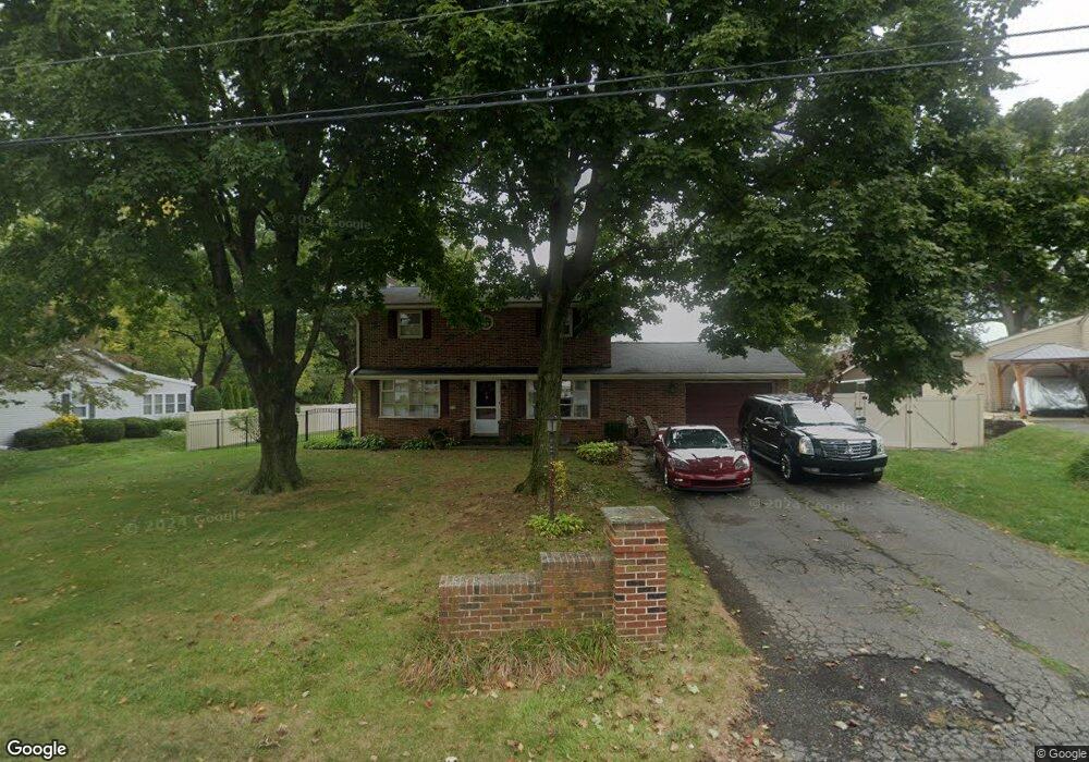
2711 Long Farm Ln Lancaster, PA 17601
Manheim Township NeighborhoodEstimated Value: $411,059 - $440,000
4
Beds
2
Baths
1,584
Sq Ft
$271/Sq Ft
Est. Value
About This Home
This home is located at 2711 Long Farm Ln, Lancaster, PA 17601 and is currently estimated at $429,265, approximately $271 per square foot. 2711 Long Farm Ln is a home located in Lancaster County with nearby schools including Neff School, Landis Run Intermediate School, and Manheim Township Middle School.
Ownership History
Date
Name
Owned For
Owner Type
Purchase Details
Closed on
Nov 10, 2000
Sold by
Buhay Paul and Buhay Janet M
Bought by
Selvaggio Mark A and Selvaggio Crystal W
Current Estimated Value
Home Financials for this Owner
Home Financials are based on the most recent Mortgage that was taken out on this home.
Original Mortgage
$131,310
Outstanding Balance
$56,956
Interest Rate
10.4%
Estimated Equity
$372,309
Create a Home Valuation Report for This Property
The Home Valuation Report is an in-depth analysis detailing your home's value as well as a comparison with similar homes in the area
Home Values in the Area
Average Home Value in this Area
Purchase History
| Date | Buyer | Sale Price | Title Company |
|---|---|---|---|
| Selvaggio Mark A | $145,900 | -- |
Source: Public Records
Mortgage History
| Date | Status | Borrower | Loan Amount |
|---|---|---|---|
| Open | Selvaggio Mark A | $131,310 |
Source: Public Records
Tax History Compared to Growth
Tax History
| Year | Tax Paid | Tax Assessment Tax Assessment Total Assessment is a certain percentage of the fair market value that is determined by local assessors to be the total taxable value of land and additions on the property. | Land | Improvement |
|---|---|---|---|---|
| 2025 | $4,786 | $221,200 | $82,700 | $138,500 |
| 2024 | $4,786 | $221,200 | $82,700 | $138,500 |
| 2023 | $4,661 | $221,200 | $82,700 | $138,500 |
| 2022 | $4,583 | $221,200 | $82,700 | $138,500 |
| 2021 | $4,481 | $221,200 | $82,700 | $138,500 |
| 2020 | $4,481 | $221,200 | $82,700 | $138,500 |
| 2019 | $4,437 | $221,200 | $82,700 | $138,500 |
| 2018 | $3,235 | $221,200 | $82,700 | $138,500 |
| 2017 | $3,964 | $155,800 | $54,900 | $100,900 |
| 2016 | $3,964 | $155,800 | $54,900 | $100,900 |
| 2015 | $996 | $155,800 | $54,900 | $100,900 |
| 2014 | $2,796 | $155,800 | $54,900 | $100,900 |
Source: Public Records
Map
Nearby Homes
- 333 Valleybrook Dr
- 202 Valleybrook Dr Unit 202
- 71 Valleybrook Dr Unit 71
- 397 Valleybrook Dr
- 441 Valleybrook Dr
- 20 Valleybrook Dr Unit 20
- 571 Laurel Ln
- 2475 Oregon Pike
- 548 E Delp Rd
- 674 Jake Landis Rd
- 2795 Southwick Dr
- 2787 Southwick Dr
- 539 Sierra Ln
- 1012 Whitfield Dr
- 1041 Hunsicker Rd
- 514 Dolly Dr
- 701 Brentwood Dr
- 2635 Beechwood Rd
- 212 Greenview Dr Unit T2212
- 614 Dolly Dr
- 2717 Long Farm Ln
- 2707 Long Farm Ln
- 2710 Long Farm Ln
- 2721 Long Farm Ln
- 685 Valley Rd
- 2716 Long Farm Ln
- 681 Valley Rd
- 2720 Long Farm Ln
- 691 Valley Rd
- 671 Valley Rd
- 2727 Long Farm Ln
- 650 Apple Rd
- 670 Valley Rd
- 43 Ashley Ct
- 2726 Long Farm Ln
- 661 Valley Rd
- 690 Valley Rd
- 2731 Long Farm Ln
- 640 Apple Rd
- 39 Ashley Ct