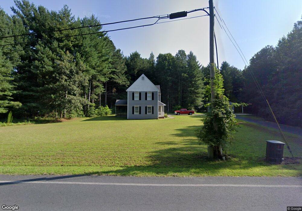
27112 Riverside Drive Extension Salisbury, MD 21801
South Salisbury NeighborhoodEstimated Value: $344,050 - $498,000
--
Bed
3
Baths
1,847
Sq Ft
$216/Sq Ft
Est. Value
About This Home
This home is located at 27112 Riverside Drive Extension, Salisbury, MD 21801 and is currently estimated at $399,263, approximately $216 per square foot. 27112 Riverside Drive Extension is a home located in Wicomico County with nearby schools including Fruitland Primary School, Fruitland Intermediate School, and Bennett Middle School.
Ownership History
Date
Name
Owned For
Owner Type
Purchase Details
Closed on
May 8, 2023
Sold by
Mugg Family Trust
Bought by
Mitchell Richard S and Mitchell Melody D
Current Estimated Value
Purchase Details
Closed on
May 23, 2002
Sold by
Jones E Marston
Bought by
Warwick Devin J
Purchase Details
Closed on
Feb 6, 2002
Sold by
Jones E Marston E and Jones Judith A
Bought by
Jones E Marston
Create a Home Valuation Report for This Property
The Home Valuation Report is an in-depth analysis detailing your home's value as well as a comparison with similar homes in the area
Home Values in the Area
Average Home Value in this Area
Purchase History
| Date | Buyer | Sale Price | Title Company |
|---|---|---|---|
| Mitchell Richard S | $799,900 | None Listed On Document | |
| Warwick Devin J | $25,000 | -- | |
| Jones E Marston | -- | -- |
Source: Public Records
Mortgage History
| Date | Status | Borrower | Loan Amount |
|---|---|---|---|
| Closed | Warwick Devin J | -- |
Source: Public Records
Tax History Compared to Growth
Tax History
| Year | Tax Paid | Tax Assessment Tax Assessment Total Assessment is a certain percentage of the fair market value that is determined by local assessors to be the total taxable value of land and additions on the property. | Land | Improvement |
|---|---|---|---|---|
| 2025 | $2,455 | $277,333 | $0 | $0 |
| 2024 | $2,455 | $249,800 | $36,900 | $212,900 |
| 2023 | $2,359 | $232,500 | $0 | $0 |
| 2022 | $2,253 | $215,200 | $0 | $0 |
| 2021 | $2,056 | $197,900 | $36,900 | $161,000 |
| 2020 | $2,056 | $193,567 | $0 | $0 |
| 2019 | $2,041 | $189,233 | $0 | $0 |
| 2018 | $2,005 | $184,900 | $36,900 | $148,000 |
| 2017 | $2,005 | $184,900 | $0 | $0 |
| 2016 | -- | $184,900 | $0 | $0 |
| 2015 | $1,809 | $187,500 | $0 | $0 |
| 2014 | $1,809 | $187,500 | $0 | $0 |
Source: Public Records
Map
Nearby Homes
- 5079 Old Mill Branch Rd
- 4916 Old Mill Branch Rd
- 5437 Nithsdale Dr
- 5461 Loch Ness Terrace
- 5474 Royal Mile Blvd
- 5541 E Nithsdale Dr
- 27336 Walnut Tree Rd
- 27671 Riverside Drive Extension
- 5088 Sailfish Dr
- 5686 N Nithsdale Dr Unit N
- 27728 Riverside Drive Extension
- 5703 Royal Mile Blvd
- 5709 Royal Mile Blvd
- 0 King Stuart Dr Unit MDWC2018516
- 5688 Kirkpatrick Ct
- 5006 Ladys Ct
- 26694 Pemberton Dr
- 5973 Smithys Ln
- 26298 High Banks Dr
- 27620 Appaloosa Dr
- 27098 Riverside Drive Extension
- 27166 Riverside Drive Extension
- 27166 Riverside Drive Extension
- 27050 Riverside Drive Extension
- 27050 Riverside Drive Extension
- 27161 Riverside Drive Extension
- 27161 Riverside Drive Extension
- 27041 Riverside Drive Extension
- 27046 Riverside Drive Extension
- 27046 Riverside Drive Extension
- 27037 Riverside Drive Extension
- 27036 Riverside Drive Extension
- 5051 Stock Creek Ln
- 27037 Riverside Drive Extension
- 27188 Riverside Drive Extension
- 27190 Riverside Drive Extension
- 27020 Riverside Drive Extension
- 27020 Riverside Drive Extension
- 27020 Riverside Drive Extension
- 27232 Riverside Drive Extension