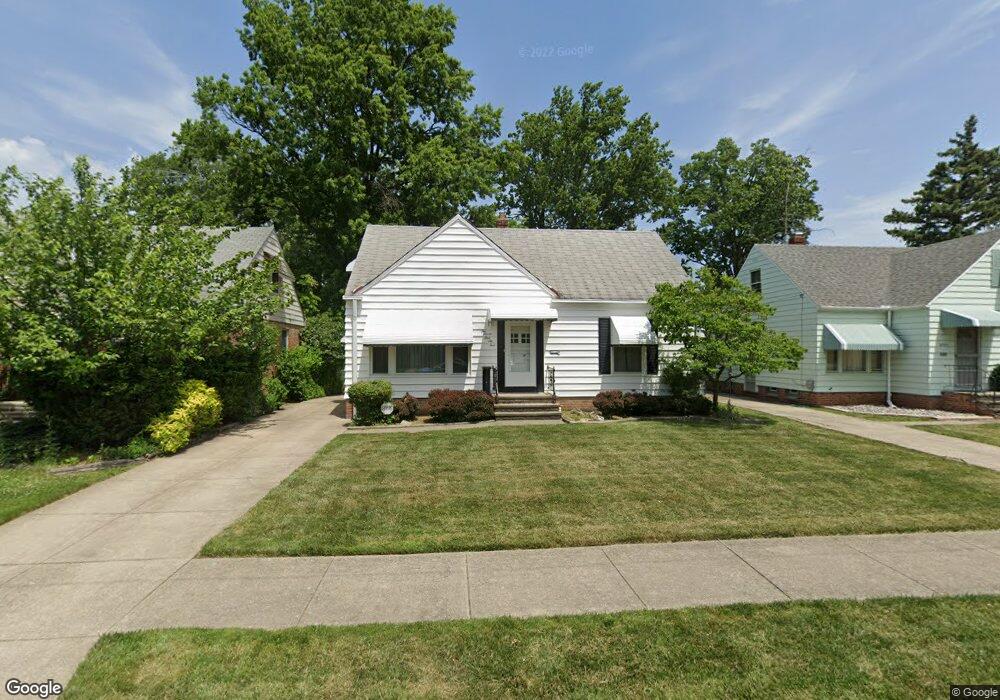
27165 Cameron Ave Euclid, OH 44132
Estimated Value: $148,113 - $178,000
3
Beds
1
Bath
1,328
Sq Ft
$125/Sq Ft
Est. Value
About This Home
This home is located at 27165 Cameron Ave, Euclid, OH 44132 and is currently estimated at $165,778, approximately $124 per square foot. 27165 Cameron Ave is a home located in Cuyahoga County with nearby schools including Shoreview Elementary School, Euclid High School, and Ss. Robert & William Catholic School.
Ownership History
Date
Name
Owned For
Owner Type
Purchase Details
Closed on
Jul 1, 2015
Sold by
Sexton John D and Sexton Geraldine C
Bought by
Sexton John D and John D Sexton Trust
Current Estimated Value
Purchase Details
Closed on
Jan 19, 1983
Sold by
Sexton John D
Bought by
Sexton John D and Sexton Geraldine C
Purchase Details
Closed on
Jan 1, 1975
Bought by
Sexton John D
Create a Home Valuation Report for This Property
The Home Valuation Report is an in-depth analysis detailing your home's value as well as a comparison with similar homes in the area
Home Values in the Area
Average Home Value in this Area
Purchase History
| Date | Buyer | Sale Price | Title Company |
|---|---|---|---|
| Sexton John D | -- | Attorney | |
| Sexton John D | -- | -- | |
| Sexton John D | -- | -- |
Source: Public Records
Tax History Compared to Growth
Tax History
| Year | Tax Paid | Tax Assessment Tax Assessment Total Assessment is a certain percentage of the fair market value that is determined by local assessors to be the total taxable value of land and additions on the property. | Land | Improvement |
|---|---|---|---|---|
| 2024 | $3,398 | $48,545 | $9,415 | $39,130 |
| 2023 | $3,212 | $36,620 | $7,110 | $29,510 |
| 2022 | $3,140 | $36,610 | $7,110 | $29,510 |
| 2021 | $3,504 | $36,610 | $7,110 | $29,510 |
| 2020 | $3,324 | $31,570 | $6,130 | $25,450 |
| 2019 | $2,997 | $90,200 | $17,500 | $72,700 |
| 2018 | $2,132 | $31,570 | $6,130 | $25,450 |
| 2017 | $2,256 | $28,460 | $5,080 | $23,380 |
| 2016 | $2,261 | $28,460 | $5,080 | $23,380 |
| 2015 | $2,060 | $28,460 | $5,080 | $23,380 |
| 2014 | $2,060 | $28,460 | $5,080 | $23,380 |
Source: Public Records
Map
Nearby Homes
- 369 E 270th St
- 440 E 271st St
- 415 E 266th St
- 461 E 271st St
- 445 E 275th St
- 459 Lloyd Rd
- 355 E 262nd St
- 625 Lloyd Rd
- 405 E 262nd St
- 559 Sycamore Dr
- 27709 Parkwood Dr
- 577 Sycamore Dr
- 295 E 276th St
- 546 Walnut Dr
- 27190 Shoreview Ave
- 26230 Oriole Ave
- 27101 Zeman Ave
- 26471 Shoreview Ave
- 25801 Lakeshore Blvd Unit 42
- 325 E 257th St
- 27155 Cameron Ave
- 27145 Cameron Ave
- 428 E 272nd St
- 27135 Cameron Ave
- 430 E 272nd St
- 426 E 272nd St
- 381 E 271st St
- 27150 Fullerwood Dr
- 27140 Fullerwood Dr
- 424 E 272nd St
- 27160 Fullerwood Dr
- 27125 Cameron Ave
- 27130 Fullerwood Dr
- 385 E 271st St
- 434 E 272nd St
- 420 E 272nd St
- 436 E 272nd St
- 27115 Cameron Ave
- 380 E 271st St
- 27120 Fullerwood Dr