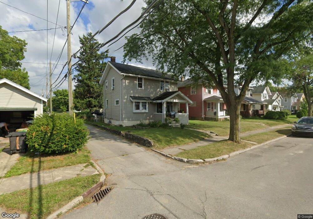
2717 Euclid Ave Fort Wayne, IN 46806
Pontiac Place NeighborhoodEstimated Value: $86,000 - $130,117
3
Beds
1
Bath
2,176
Sq Ft
$47/Sq Ft
Est. Value
About This Home
This home is located at 2717 Euclid Ave, Fort Wayne, IN 46806 and is currently estimated at $102,529, approximately $47 per square foot. 2717 Euclid Ave is a home located in Allen County with nearby schools including Lincoln Elementary School, Shawnee Middle School, and Northrop High School.
Ownership History
Date
Name
Owned For
Owner Type
Purchase Details
Closed on
Jan 15, 2019
Sold by
2717 Euclid Avenue Land Trust
Bought by
Revolorio Jose Leonel De Cid and Ruiz Elida Marina
Current Estimated Value
Purchase Details
Closed on
Nov 18, 2013
Sold by
Auditor Of The County Of Allen
Bought by
2717 Euclid Avenue Land Trust
Purchase Details
Closed on
Mar 10, 2006
Sold by
State Bank & Trust Co
Bought by
Gathman Randall R
Purchase Details
Closed on
Jun 1, 2003
Sold by
Castleberry Tamara
Bought by
Emerson Investment Group Inc
Home Financials for this Owner
Home Financials are based on the most recent Mortgage that was taken out on this home.
Original Mortgage
$602,895
Interest Rate
7%
Mortgage Type
Seller Take Back
Create a Home Valuation Report for This Property
The Home Valuation Report is an in-depth analysis detailing your home's value as well as a comparison with similar homes in the area
Home Values in the Area
Average Home Value in this Area
Purchase History
| Date | Buyer | Sale Price | Title Company |
|---|---|---|---|
| Revolorio Jose Leonel De Cid | $23,000 | Village Real Estate Company | |
| 2717 Euclid Avenue Land Trust | $6,000 | None Available | |
| Gathman Randall R | -- | Commonwealth-Dreibelbiss Tit | |
| Emerson Investment Group Inc | $612,895 | -- |
Source: Public Records
Mortgage History
| Date | Status | Borrower | Loan Amount |
|---|---|---|---|
| Previous Owner | Emerson Investment Group Inc | $602,895 |
Source: Public Records
Tax History Compared to Growth
Tax History
| Year | Tax Paid | Tax Assessment Tax Assessment Total Assessment is a certain percentage of the fair market value that is determined by local assessors to be the total taxable value of land and additions on the property. | Land | Improvement |
|---|---|---|---|---|
| 2024 | $1,463 | $72,000 | $15,000 | $57,000 |
| 2022 | $1,193 | $53,100 | $6,000 | $47,100 |
| 2021 | $1,010 | $45,100 | $1,100 | $44,000 |
| 2020 | $1,007 | $46,000 | $1,100 | $44,900 |
| 2019 | $640 | $29,400 | $1,100 | $28,300 |
| 2018 | $594 | $27,100 | $1,100 | $26,000 |
| 2017 | $564 | $25,500 | $1,100 | $24,400 |
| 2016 | $495 | $22,700 | $1,100 | $21,600 |
| 2014 | $251 | $12,100 | $1,100 | $11,000 |
| 2013 | $301 | $14,500 | $1,100 | $13,400 |
Source: Public Records
Map
Nearby Homes
- 442 E Pontiac St
- 1115 E Pontiac St
- 1131 E Pontiac St
- 1117 E Pontiac St
- 1629 Colerick St
- 2832 Abbott St
- 2747 Abbott St
- 3110 Central Dr
- 3105 Plaza Dr
- 3201 S Anthony Blvd
- 1411 Fisher St
- 3025 Holton Ave
- 3002 Holton Ave
- 1514 E Creighton Ave
- 3123 Holton Ave
- 1220 Colerick St
- 3213 Robinwood Dr
- 3314 Reed St
- 2533 Evans St
- 3115 Bowser Ave
- 2719 Euclid Ave
- 2725 Euclid Ave
- 1906 E Pontiac St
- 1902 E Pontiac St
- 1916 E Pontiac St
- 2727 Euclid Ave
- 2716 Central Dr
- 1918 E Pontiac St
- 2720 Central Dr
- 2801 Euclid Ave
- 2724 Central Dr
- 1824 E Pontiac St
- 2718 Euclid Ave
- 2720 Euclid Ave
- 2728 Central Dr
- 2724 Euclid Ave
- 2805 Euclid Ave
- 1926 E Pontiac St
- 2802 Central Dr
- 2730 Euclid Ave