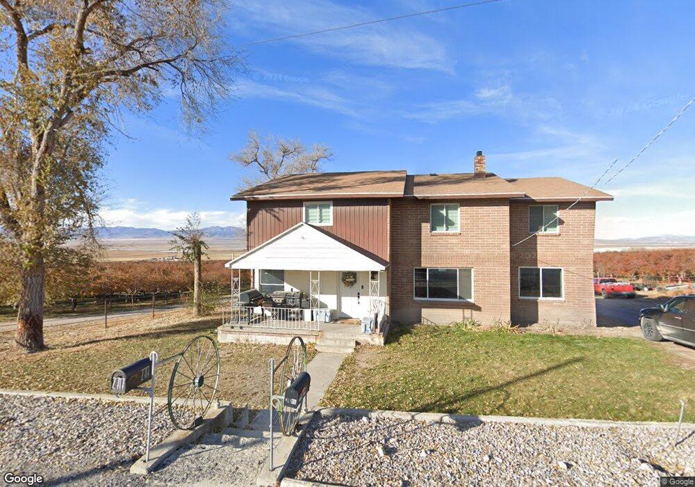
2717 N 800 W Genola, UT 84655
Estimated Value: $500,000 - $747,000
2
Beds
2
Baths
5,040
Sq Ft
$128/Sq Ft
Est. Value
About This Home
This home is located at 2717 N 800 W, Genola, UT 84655 and is currently estimated at $644,381, approximately $127 per square foot. 2717 N 800 W is a home located in Utah County with nearby schools including Goshen Elementary school, Payson High School, and Payson Junior High School.
Ownership History
Date
Name
Owned For
Owner Type
Purchase Details
Closed on
Jul 28, 2014
Sold by
Federal National Mortgage Association
Bought by
S Henstra Llc
Current Estimated Value
Purchase Details
Closed on
Jan 22, 2014
Sold by
Liddiard Steven Blake and Americas Wholesale Lender
Bought by
Federal National Mortgage Association
Purchase Details
Closed on
Dec 12, 2000
Sold by
Liddiard Steven B
Bought by
Liddiard Steven Blake
Home Financials for this Owner
Home Financials are based on the most recent Mortgage that was taken out on this home.
Original Mortgage
$140,000
Interest Rate
7.81%
Purchase Details
Closed on
Jan 23, 1998
Sold by
Liddiard Steven Blake and Maxwell Elizabeth
Bought by
Liddiard Steven B and Maxwell Christine E
Home Financials for this Owner
Home Financials are based on the most recent Mortgage that was taken out on this home.
Original Mortgage
$120,000
Interest Rate
7.05%
Create a Home Valuation Report for This Property
The Home Valuation Report is an in-depth analysis detailing your home's value as well as a comparison with similar homes in the area
Home Values in the Area
Average Home Value in this Area
Purchase History
| Date | Buyer | Sale Price | Title Company |
|---|---|---|---|
| S Henstra Llc | $150,000 | Etitle Insurance Agency | |
| Federal National Mortgage Association | $151,835 | Etitle Insurance Agency | |
| Liddiard Steven Blake | -- | Superior Title Company | |
| Liddiard Steven B | -- | -- |
Source: Public Records
Mortgage History
| Date | Status | Borrower | Loan Amount |
|---|---|---|---|
| Previous Owner | Liddiard Steven Blake | $140,000 | |
| Previous Owner | Liddiard Steven B | $120,000 |
Source: Public Records
Tax History Compared to Growth
Tax History
| Year | Tax Paid | Tax Assessment Tax Assessment Total Assessment is a certain percentage of the fair market value that is determined by local assessors to be the total taxable value of land and additions on the property. | Land | Improvement |
|---|---|---|---|---|
| 2025 | $1,451 | $172,298 | $238,800 | $222,300 |
| 2024 | $1,451 | $150,103 | $0 | $0 |
| 2023 | $1,425 | $147,696 | $0 | $0 |
| 2022 | $1,321 | $398,800 | $242,500 | $156,300 |
| 2021 | $1,144 | $291,300 | $163,300 | $128,000 |
| 2020 | $906 | $266,300 | $142,000 | $124,300 |
| 2019 | $491 | $181,500 | $121,400 | $60,100 |
| 2018 | $461 | $158,700 | $106,400 | $52,300 |
| 2017 | $472 | $40,297 | $0 | $0 |
| 2016 | $739 | $63,425 | $0 | $0 |
| 2015 | $676 | $76,515 | $0 | $0 |
| 2014 | $835 | $160,445 | $0 | $0 |
Source: Public Records
Map
Nearby Homes
- 10686 Lincoln Beach Blvd
- 956 N Main St
- 1220 N Hillside Dr
- 10336 S 6000 W
- 9054 S 6200 W
- 5746 W 11300 S
- 5635 W 11300 S
- 11363 S 5600 West St
- 11433 S 5600 West St
- 11433 S 5600 W
- 5959 W 8000 S
- 10900 S 5200 W
- 5132 W 10400 S
- 1010 S Anna Ekins Memorial Ln
- 4050 W 9600 S
- 841 N Dryland Cir Unit BALLAR
- 841 N Dryland Cir Unit DREXEL
- 841 N Dryland Cir Unit HILDAL
- 841 N Dryland Cir Unit WINDSR
- 841 N Dryland Cir Unit WAKEFI