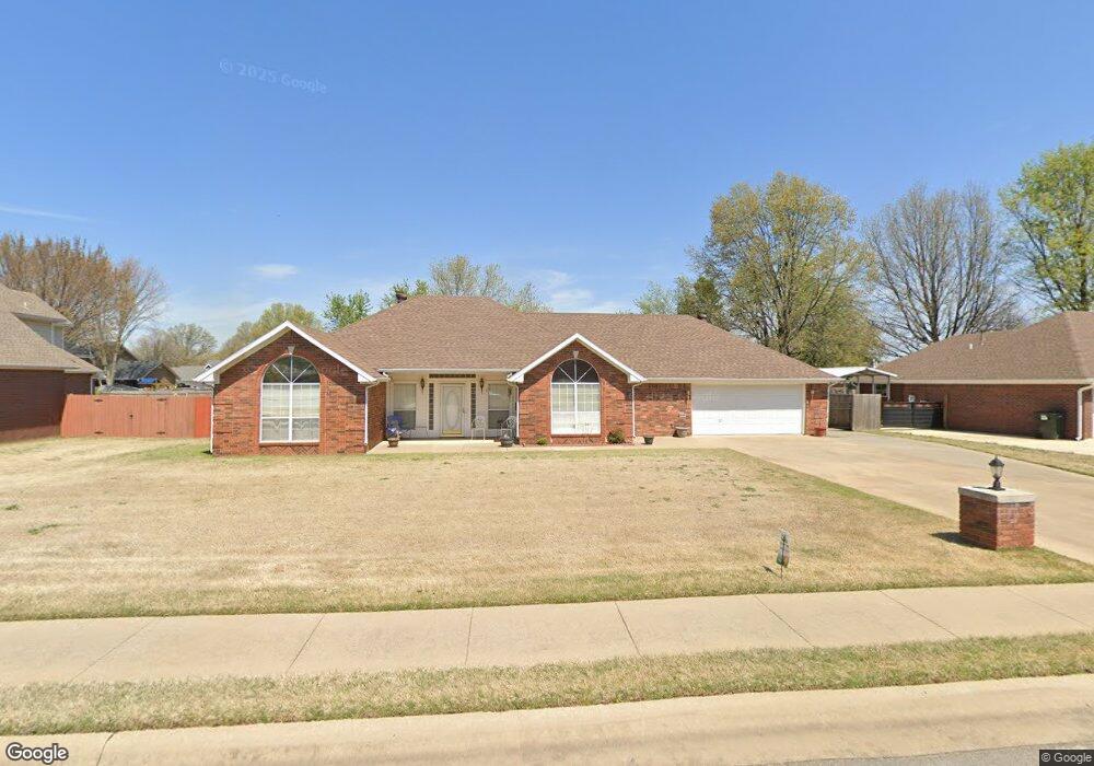
272 Countryside Dr Farmington, AR 72730
Estimated Value: $352,000 - $415,000
--
Bed
3
Baths
2,117
Sq Ft
$181/Sq Ft
Est. Value
About This Home
This home is located at 272 Countryside Dr, Farmington, AR 72730 and is currently estimated at $384,082, approximately $181 per square foot. 272 Countryside Dr is a home located in Washington County with nearby schools including Randall G. Lynch Middle School, Bob Folsom Elementary School, and Farmington Jr. High.
Ownership History
Date
Name
Owned For
Owner Type
Purchase Details
Closed on
May 21, 1996
Bought by
Thurman Ira J and Thurman Verna M
Current Estimated Value
Purchase Details
Closed on
Feb 10, 1995
Bought by
Carr Robert N
Purchase Details
Closed on
Jan 1, 1994
Bought by
Commercial Properties, Inc.
Create a Home Valuation Report for This Property
The Home Valuation Report is an in-depth analysis detailing your home's value as well as a comparison with similar homes in the area
Home Values in the Area
Average Home Value in this Area
Purchase History
| Date | Buyer | Sale Price | Title Company |
|---|---|---|---|
| Thurman Ira J | $130,000 | -- | |
| Carr Robert N | $19,000 | -- | |
| Commercial Properties, Inc. | -- | -- |
Source: Public Records
Tax History Compared to Growth
Tax History
| Year | Tax Paid | Tax Assessment Tax Assessment Total Assessment is a certain percentage of the fair market value that is determined by local assessors to be the total taxable value of land and additions on the property. | Land | Improvement |
|---|---|---|---|---|
| 2025 | $987 | $69,200 | $13,500 | $55,700 |
| 2024 | $1,102 | $69,200 | $13,500 | $55,700 |
| 2023 | $1,246 | $69,200 | $13,500 | $55,700 |
| 2022 | $1,296 | $40,710 | $9,000 | $31,710 |
| 2021 | $1,305 | $40,710 | $9,000 | $31,710 |
| 2020 | $1,305 | $40,710 | $9,000 | $31,710 |
| 2019 | $1,312 | $36,420 | $9,000 | $27,420 |
| 2018 | $1,337 | $36,420 | $9,000 | $27,420 |
| 2017 | $1,321 | $36,420 | $9,000 | $27,420 |
| 2016 | $1,321 | $36,420 | $9,000 | $27,420 |
| 2015 | $1,321 | $36,420 | $9,000 | $27,420 |
| 2014 | $1,321 | $31,175 | $4,410 | $26,765 |
Source: Public Records
Map
Nearby Homes
- Rye 1903 Plan at The Grove at Engles Mill
- Ouachita 1669 Plan at The Grove at Engles Mill
- Cache 1788 Plan at The Grove at Engles Mill
- Degray 1757 Plan at The Grove at Engles Mill
- Stella 1848 Plan at The Grove at Engles Mill
- Millwood 1862 Plan at The Grove at Engles Mill
- Magnolia 1556 Plan at The Grove at Engles Mill
- Eureka 1536 Plan at The Grove at Engles Mill
- Springs 1445 Plan at The Grove at Engles Mill
- Piper 2064 Plan at The Grove at Engles Mill
- Oak 1463 Plan at The Grove at Engles Mill
- Daisy 2147 Plan at The Grove at Engles Mill
- Ashton 1496 Plan at The Grove at Engles Mill
- Hendrix 1983 Plan at The Grove at Engles Mill
- Osage 1567 Plan at The Grove at Engles Mill
- Maple 1659 Plan at The Grove at Engles Mill
- 201 Countryside Dr
- 0 W Main St Unit 1281343
- 0 W Main St Unit 1291778
- 0 W Main St Unit 1291878
- 280 Countryside Dr
- 264 Countryside Dr
- 273 Wedgeview Dr
- 281 Wedgeview Dr
- 265 Wedgeview Dr
- 256 Countryside Dr
- 288 Countryside Dr
- 271 Countryside Dr
- 279 Countryside Dr
- 263 Countryside Dr
- 257 Wedgeview Dr
- 289 Wedgeview Dr
- 287 Countryside Dr
- 255 Countryside Dr
- 248 Countryside Dr
- 249 Wedgeview Dr
- 432 W Tyler Rd
- 297 Wedgeview Dr
- 426 W Tyler Rd
- 438 W Tyler Rd