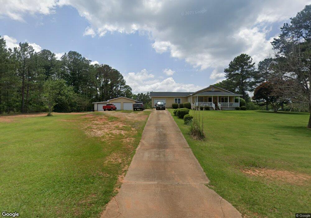
272 Mauldin Rd Thomaston, GA 30286
Estimated Value: $211,000 - $284,613
2
Beds
2
Baths
1,458
Sq Ft
$170/Sq Ft
Est. Value
About This Home
This home is located at 272 Mauldin Rd, Thomaston, GA 30286 and is currently estimated at $248,403, approximately $170 per square foot. 272 Mauldin Rd is a home located in Upson County with nearby schools including Upson-Lee South Elementary School, Upson-Lee North Elementary School, and Upson-Lee Middle School.
Ownership History
Date
Name
Owned For
Owner Type
Purchase Details
Closed on
Jan 29, 2021
Sold by
Johnson Garry
Bought by
Grossman Tina R and Grossman Brian L
Current Estimated Value
Home Financials for this Owner
Home Financials are based on the most recent Mortgage that was taken out on this home.
Original Mortgage
$114,000
Interest Rate
2.7%
Mortgage Type
New Conventional
Purchase Details
Closed on
Dec 4, 2020
Sold by
Cooper Martha
Bought by
Grossman Brian L and Grossman Tina R
Home Financials for this Owner
Home Financials are based on the most recent Mortgage that was taken out on this home.
Original Mortgage
$114,000
Interest Rate
2.7%
Mortgage Type
New Conventional
Create a Home Valuation Report for This Property
The Home Valuation Report is an in-depth analysis detailing your home's value as well as a comparison with similar homes in the area
Purchase History
We collect this data history from publicly available records. To have your information removed, we recommend requesting removal directly through your county’s website.
| Date | Buyer | Sale Price | Title Company |
|---|---|---|---|
| Grossman Tina R | -- | -- | |
| Grossman Brian L | $120,000 | -- |
Source: Public Records
Mortgage History
We collect this data history from publicly available records. To have your information removed, we recommend requesting removal directly through your county’s website.
| Date | Status | Borrower | Loan Amount |
|---|---|---|---|
| Previous Owner | Grossman Brian L | $114,000 |
Source: Public Records
Tax History
| Year | Tax Paid | Tax Assessment Tax Assessment Total Assessment is a certain percentage of the fair market value that is determined by local assessors to be the total taxable value of land and additions on the property. | Land | Improvement |
|---|---|---|---|---|
| 2025 | $2,145 | $88,750 | $29,950 | $58,800 |
| 2024 | $2,145 | $82,358 | $24,958 | $57,400 |
| 2023 | $2,163 | $80,314 | $24,958 | $55,356 |
| 2022 | $1,706 | $61,536 | $17,856 | $43,680 |
| 2021 | $1,265 | $54,673 | $17,797 | $36,876 |
| 2020 | $1,277 | $45,269 | $16,428 | $28,841 |
| 2019 | $1,044 | $43,219 | $16,428 | $26,791 |
| 2018 | $1,045 | $43,219 | $16,428 | $26,791 |
| 2017 | $1,096 | $41,536 | $16,428 | $25,108 |
| 2016 | $940 | $36,455 | $13,690 | $22,765 |
| 2015 | $939 | $36,455 | $13,690 | $22,765 |
| 2014 | $784 | $31,915 | $9,150 | $22,765 |
Source: Public Records
Map
Nearby Homes
- 291 Mauldin Rd
- 0 Stone Ln Unit 10514742
- 47 Childrees Rd
- 5911 Indian Trail
- 1224 Waymanville Rd
- 1591 Waymanville Rd
- 112 Pasley St
- 0 Highway 19 S Unit 24061935
- 2088 Wiley St
- 0 Davis Lake Rd Unit 10511531
- 0 Goshen Rd Unit 10695051
- 0 Goshen Rd Unit 26382561
- 107 Hammerhead Ln
- 615 Peachtree Dr
- 204 Diane Dr
- 315 Dallas Dr
- 705 Triune Mill Rd
- 807 Triune Mill Rd
- 406 Brookwood Dr
- 213 Jefferson St
Your Personal Tour Guide
Ask me questions while you tour the home.