Estimated Value: $248,152 - $295,000
About This Home
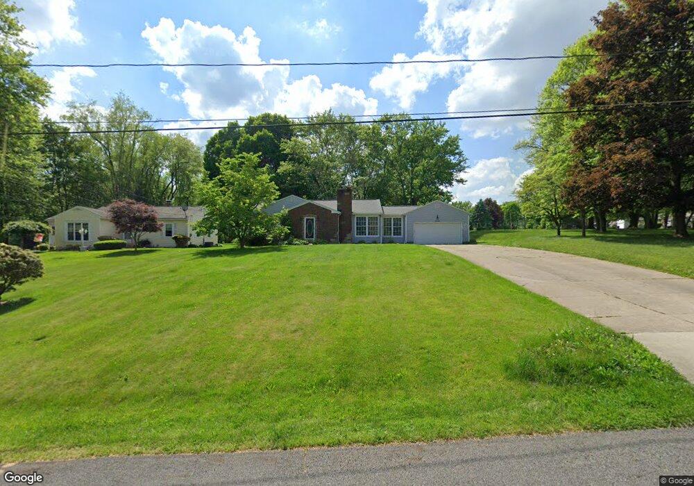
This home is located at 272 N Messner Rd, Akron, OH 44319 and is currently estimated at $273,038, approximately $169 per square foot. 272 N Messner Rd is a home located in Summit County with nearby schools including Nolley Elementary School, Manchester Middle School, and Manchester High School.
Ownership History
We collect this data history from publicly available records. To have your information removed, we recommend requesting removal directly through your county’s website.
Purchase Details
Purchase Details
Home Financials for this Owner
Home Financials are based on the most recent Mortgage that was taken out on this home.Purchase Details
Home Financials for this Owner
Home Financials are based on the most recent Mortgage that was taken out on this home.Home Values in the Area
Average Home Value in this Area
Purchase History
We collect this data history from publicly available records. To have your information removed, we recommend requesting removal directly through your county’s website.
| Date | Buyer | Sale Price | Title Company |
|---|---|---|---|
| -- | None Available | ||
| $146,000 | Real Estate Title | ||
| $142,000 | Bond & Associates Title Agen |
Mortgage History
We collect this data history from publicly available records. To have your information removed, we recommend requesting removal directly through your county’s website.
| Date | Status | Borrower | Loan Amount |
|---|---|---|---|
| Previous Owner | $124,100 | ||
| Previous Owner | $134,900 |
Tax History
We collect this data history from publicly available records. To have your information removed, we recommend requesting removal directly through your county’s website.
| Year | Tax Paid | Tax Assessment Tax Assessment Total Assessment is a certain percentage of the fair market value that is determined by local assessors to be the total taxable value of land and additions on the property. | Land | Improvement |
|---|---|---|---|---|
| 2026 | $7,913 | $73,420 | $15,456 | $57,964 |
| 2024 | $3,666 | $73,420 | $15,456 | $57,964 |
| 2023 | $3,666 | $73,420 | $15,456 | $57,964 |
| 2022 | $3,368 | $52,549 | $10,962 | $41,587 |
| 2021 | $3,380 | $52,549 | $10,962 | $41,587 |
| 2020 | $3,322 | $52,550 | $10,960 | $41,590 |
| 2019 | $3,356 | $47,600 | $8,990 | $38,610 |
| 2018 | $2,895 | $47,600 | $8,990 | $38,610 |
| 2017 | $2,779 | $47,600 | $8,990 | $38,610 |
| 2016 | $2,784 | $41,400 | $8,990 | $32,410 |
| 2015 | $2,779 | $41,400 | $8,990 | $32,410 |
| 2014 | $2,758 | $41,400 | $8,990 | $32,410 |
| 2013 | $2,862 | $43,220 | $8,990 | $34,230 |
Map
- 41 W Nimisila Rd
- 5261 Dailey Rd
- 5862 Canterbury Rd
- 568 W Nimisila Rd
- 408 Center Rd
- 5838 Harter Home Dr
- 752 Leeman Dr
- 708 Fairwood Rd
- 6235 Manchester Rd
- 5942 Noreast Dr
- 6308 Manchester Rd
- 4 Shrakes Hotel Dr
- 6 Shrakes Hotel Dr
- 7 Shrakes Hotel Dr
- 3 Shrakes Hotel Dr
- 6090 Manchester Rd Unit 6096
- 5912 Woodward Dr
- 4944 Coleman Dr
- 4781 Laburnum Dr
- 4741 Laburnum Dr
- 262 N Messner Rd
- 318 N Messner Rd
- 240 N Messner Rd Unit 244
- 324 N Messner Rd
- 271 N Messner Rd
- 307 N Messner Rd
- 253 N Messner Rd
- 331 N Messner Rd
- 236 N Messner Rd Unit 238
- 236 N Messner Rd
- 291 N Messner Rd
- 323 N Messner Rd
- 257 N Messner Rd
- 281 N Messner Rd
- 340 N Messner Rd
- 232 N Messner Rd
- 341 N Messner Rd
- 5617 Dailey Rd
- 241 N Messner Rd
- 350 N Messner Rd
Ask me questions while you tour the home.