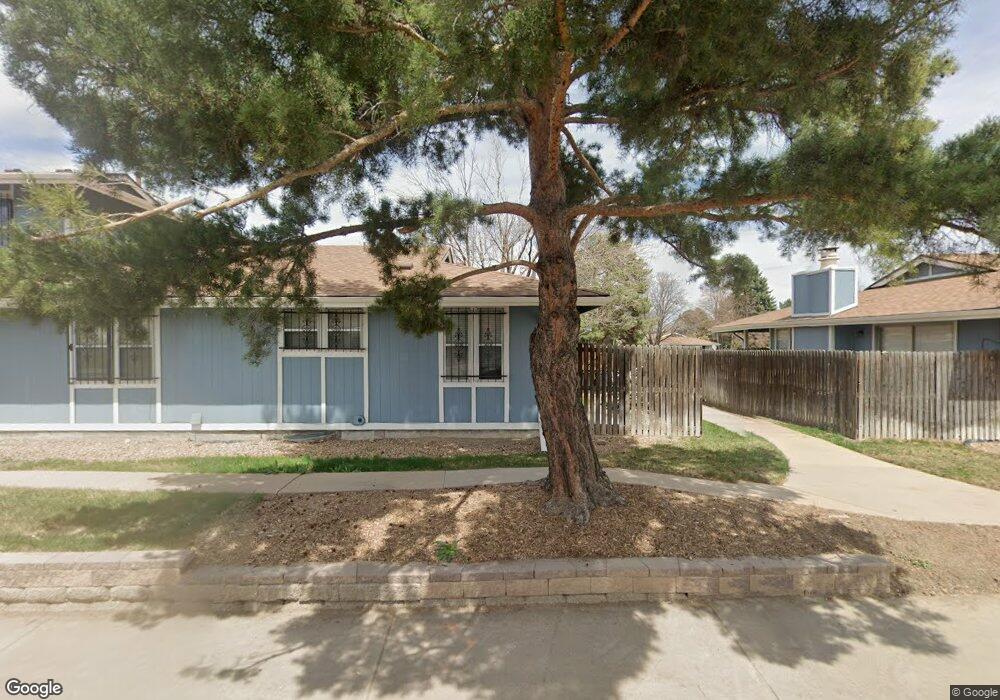
272 S Newark Cir Aurora, CO 80012
Highline Villages NeighborhoodEstimated Value: $305,000 - $356,000
3
Beds
3
Baths
1,224
Sq Ft
$268/Sq Ft
Est. Value
About This Home
This home is located at 272 S Newark Cir, Aurora, CO 80012 and is currently estimated at $327,552, approximately $267 per square foot. 272 S Newark Cir is a home located in Arapahoe County with nearby schools including Lansing Elementary Community School, Del Mar Academy, and Aurora Hills Middle School.
Ownership History
Date
Name
Owned For
Owner Type
Purchase Details
Closed on
Feb 17, 2017
Sold by
Manning I Frederic Trevor
Bought by
Manning I Frederic Trevor and Manning Nancy Anne
Current Estimated Value
Purchase Details
Closed on
Jun 6, 2008
Sold by
Manning W Ruth
Bought by
Manning F Trevor
Purchase Details
Closed on
Oct 10, 1995
Sold by
Ruthcrowe W
Bought by
Manning W Ruth
Purchase Details
Closed on
Dec 31, 1990
Sold by
Conversion Arapco
Bought by
Crowe W Ruth
Purchase Details
Closed on
Mar 1, 1981
Sold by
Conversion Arapco
Bought by
Conversion Arapco
Purchase Details
Closed on
Jul 4, 1776
Bought by
Conversion Arapco
Create a Home Valuation Report for This Property
The Home Valuation Report is an in-depth analysis detailing your home's value as well as a comparison with similar homes in the area
Home Values in the Area
Average Home Value in this Area
Purchase History
| Date | Buyer | Sale Price | Title Company |
|---|---|---|---|
| Manning I Frederic Trevor | -- | None Available | |
| Manning F Trevor | -- | None Available | |
| Manning W Ruth | -- | -- | |
| Crowe W Ruth | -- | -- | |
| Conversion Arapco | -- | -- | |
| Conversion Arapco | -- | -- |
Source: Public Records
Tax History Compared to Growth
Tax History
| Year | Tax Paid | Tax Assessment Tax Assessment Total Assessment is a certain percentage of the fair market value that is determined by local assessors to be the total taxable value of land and additions on the property. | Land | Improvement |
|---|---|---|---|---|
| 2024 | $1,765 | $18,995 | -- | -- |
| 2023 | $1,765 | $18,995 | $0 | $0 |
| 2022 | $1,847 | $18,390 | $0 | $0 |
| 2021 | $1,906 | $18,390 | $0 | $0 |
| 2020 | $1,633 | $15,687 | $0 | $0 |
| 2019 | $1,625 | $15,687 | $0 | $0 |
| 2018 | $1,482 | $14,018 | $0 | $0 |
| 2017 | $1,289 | $14,018 | $0 | $0 |
| 2016 | $1,095 | $11,654 | $0 | $0 |
| 2015 | $1,057 | $11,654 | $0 | $0 |
| 2014 | $838 | $8,899 | $0 | $0 |
| 2013 | -- | $8,650 | $0 | $0 |
Source: Public Records
Map
Nearby Homes
- 11608 E Cedar Ave
- 11609 E Cedar Ave
- 128 S Moline St
- 11620 E Bayaud Dr
- 100 S Moline St
- 87 S Nome St
- 105 S Nome St
- 11101 E Alameda Ave Unit 202
- 56 S Nome St
- 126 S Nome St
- 11103 E Alameda Ave Unit 102
- 11115 E Alameda Ave Unit 202
- 11759 E Alaska Ave
- 11902 E Maple Ave
- 351 S Peoria Cir
- 11623 E Virginia Dr
- 12072 E Maple Ave
- 11812 E Alaska Ave
- 12024 E Maple Ave
- 62 Newark St Unit C
- 274 S Newark Cir
- 276 S Newark Cir
- 268 S Newark Cir
- 278 S Newark Cir
- 266 S Newark Cir
- 296 S Newark Cir
- 298 S Newark Cir
- 294 S Newark Cir
- 292 S Newark Cir
- 288 S Newark Cir
- 262 S Newark Cir
- 284 S Newark Cir
- 286 S Newark Cir
- 254 S Newark Cir
- 271 S Newark Cir
- 273 S Newark Cir
- 263 S Newark Cir
- 252 S Newark Cir
- 11511 E Dakota Ave
- 253 S Newark Cir