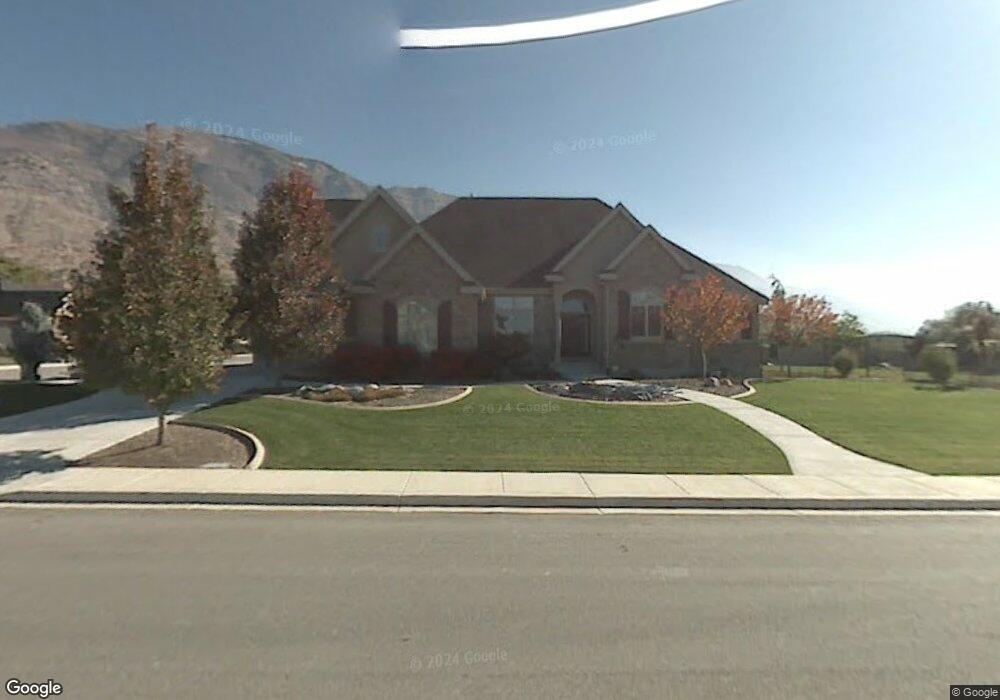
2720 N 550 W Pleasant Grove, UT 84062
Estimated Value: $1,137,000 - $1,469,729
6
Beds
6
Baths
5,583
Sq Ft
$236/Sq Ft
Est. Value
About This Home
This home is located at 2720 N 550 W, Pleasant Grove, UT 84062 and is currently estimated at $1,319,932, approximately $236 per square foot. 2720 N 550 W is a home located in Utah County with nearby schools including Deerfield Elementary School, Mountain Ridge Junior High School, and American Fork High School.
Ownership History
Date
Name
Owned For
Owner Type
Purchase Details
Closed on
Jun 25, 2018
Sold by
Dotson Roger F and The Roger F Dotson Living Trus
Bought by
Cuff Ryan and Cuff Lisa
Current Estimated Value
Home Financials for this Owner
Home Financials are based on the most recent Mortgage that was taken out on this home.
Original Mortgage
$453,100
Outstanding Balance
$392,733
Interest Rate
4.6%
Mortgage Type
New Conventional
Estimated Equity
$927,199
Purchase Details
Closed on
Feb 23, 2005
Sold by
Keller Douglas Craig and Keller Janet
Bought by
Dotson Roger Floyd and Monroe Jamie Maria
Home Financials for this Owner
Home Financials are based on the most recent Mortgage that was taken out on this home.
Original Mortgage
$187,600
Interest Rate
5.65%
Mortgage Type
Credit Line Revolving
Purchase Details
Closed on
Dec 22, 2003
Sold by
Keller Douglas Craig and Keller Janet
Bought by
Keller Douglas Craig and Keller Janet
Purchase Details
Closed on
Feb 6, 2003
Sold by
Brinkerhoff Roger and Brinkerhoff Alyce
Bought by
Keller Douglas Craig and Keller Janet
Home Financials for this Owner
Home Financials are based on the most recent Mortgage that was taken out on this home.
Original Mortgage
$250,000
Interest Rate
5.83%
Purchase Details
Closed on
Jul 22, 2002
Sold by
Robison Gene B and Robison Karen T
Bought by
Brinkerhoff Roger and Brinkerhoff Alyce
Create a Home Valuation Report for This Property
The Home Valuation Report is an in-depth analysis detailing your home's value as well as a comparison with similar homes in the area
Home Values in the Area
Average Home Value in this Area
Purchase History
| Date | Buyer | Sale Price | Title Company |
|---|---|---|---|
| Cuff Ryan | -- | Provo Land Title Co | |
| Dotson Roger Floyd | -- | Equity Title | |
| Keller Douglas Craig | -- | -- | |
| Keller Douglas Craig | -- | Provo Land Title Company | |
| Brinkerhoff Roger | -- | Provo Land Title Company |
Source: Public Records
Mortgage History
| Date | Status | Borrower | Loan Amount |
|---|---|---|---|
| Open | Cuff Ryan | $453,100 | |
| Previous Owner | Dotson Roger Floyd | $187,600 | |
| Previous Owner | Dotson Roger Floyd | $250,000 | |
| Previous Owner | Keller Douglas Craig | $250,000 |
Source: Public Records
Tax History Compared to Growth
Tax History
| Year | Tax Paid | Tax Assessment Tax Assessment Total Assessment is a certain percentage of the fair market value that is determined by local assessors to be the total taxable value of land and additions on the property. | Land | Improvement |
|---|---|---|---|---|
| 2025 | $5,181 | $710,215 | $462,200 | $829,100 |
| 2024 | $5,181 | $618,145 | $0 | $0 |
| 2023 | $5,008 | $611,875 | $0 | $0 |
| 2022 | $4,793 | $582,670 | $0 | $0 |
| 2021 | $4,075 | $754,200 | $263,000 | $491,200 |
| 2020 | $3,848 | $698,300 | $243,500 | $454,800 |
| 2019 | $3,628 | $680,900 | $226,100 | $454,800 |
| 2018 | $3,739 | $663,500 | $208,700 | $454,800 |
| 2017 | $3,759 | $355,080 | $0 | $0 |
| 2016 | $3,356 | $306,020 | $0 | $0 |
| 2015 | $3,392 | $292,930 | $0 | $0 |
| 2014 | $2,966 | $253,715 | $0 | $0 |
Source: Public Records
Map
Nearby Homes
- 2837 N 550 W
- 8923 N Cottage Canyon Dr
- 9078 Renaissance Dr
- 8905 N Pine Hollow Dr
- 9157 N Canyon Heights Dr
- 3408 W Bear Canyon Ln N Unit 53
- 3373 Bear Canyon Ln
- 532 W 2000 N
- 2969 N 1350 W
- 8944 Silver Lake Dr
- 3810 W Valley View Dr
- 1897 N 900 W
- 980 W 1800 N
- 9481 N 3830 W
- 636 N 1280 E
- 2254 N 1560 W
- 9547 N Canyon Rd
- 598 N 1280 E
- 9506 N 4000 W
- 649 N 1280 E