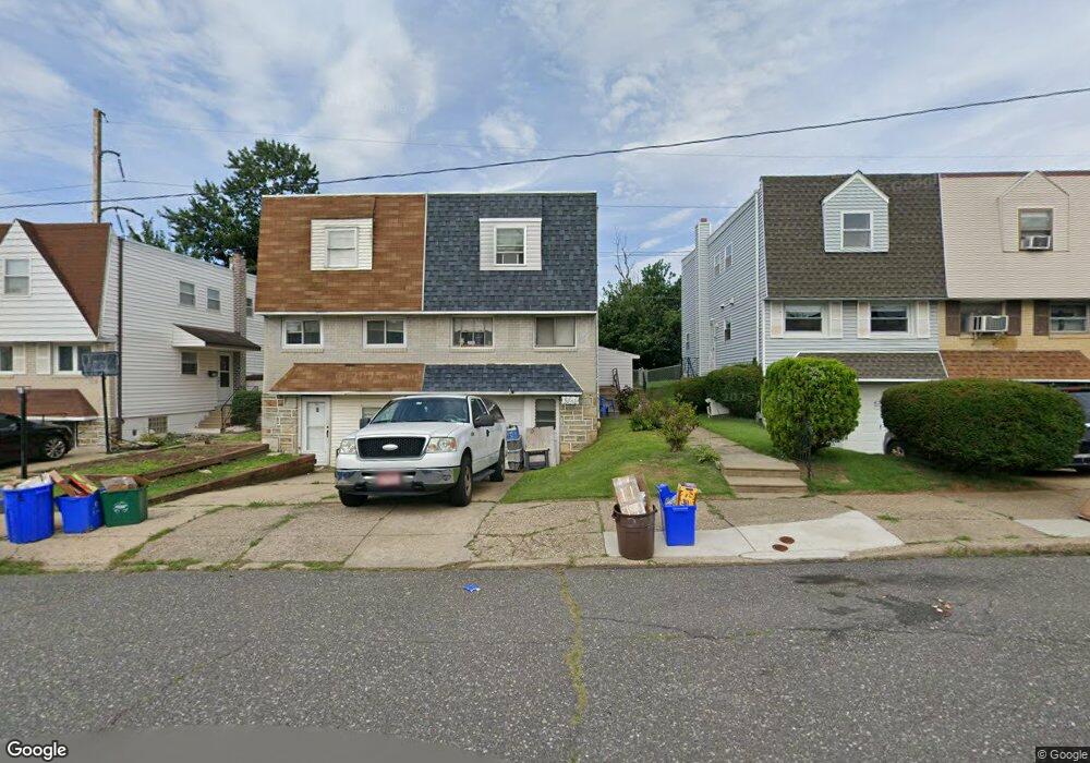
2722 Maxwell St Philadelphia, PA 19136
Pennypack NeighborhoodEstimated Value: $267,000 - $295,000
--
Bed
1
Bath
1,152
Sq Ft
$244/Sq Ft
Est. Value
About This Home
This home is located at 2722 Maxwell St, Philadelphia, PA 19136 and is currently estimated at $281,553, approximately $244 per square foot. 2722 Maxwell St is a home with nearby schools including Lincoln High School, Robert B. Pollock School, and Meehan Austin Middle School.
Ownership History
Date
Name
Owned For
Owner Type
Purchase Details
Closed on
Aug 20, 2022
Sold by
Gorey Michael F
Bought by
Gorey Michael F
Current Estimated Value
Home Financials for this Owner
Home Financials are based on the most recent Mortgage that was taken out on this home.
Original Mortgage
$125,000
Interest Rate
6.7%
Mortgage Type
New Conventional
Purchase Details
Closed on
Dec 19, 1992
Bought by
Gorey Michael F and Gorey Georgette
Create a Home Valuation Report for This Property
The Home Valuation Report is an in-depth analysis detailing your home's value as well as a comparison with similar homes in the area
Home Values in the Area
Average Home Value in this Area
Purchase History
| Date | Buyer | Sale Price | Title Company |
|---|---|---|---|
| Gorey Michael F | -- | -- | |
| Gorey Michael F | $72,000 | -- |
Source: Public Records
Mortgage History
| Date | Status | Borrower | Loan Amount |
|---|---|---|---|
| Previous Owner | Gorey Michael F | $125,000 |
Source: Public Records
Tax History Compared to Growth
Tax History
| Year | Tax Paid | Tax Assessment Tax Assessment Total Assessment is a certain percentage of the fair market value that is determined by local assessors to be the total taxable value of land and additions on the property. | Land | Improvement |
|---|---|---|---|---|
| 2026 | $3,302 | $291,700 | $58,340 | $233,360 |
| 2025 | $3,302 | $291,700 | $58,340 | $233,360 |
| 2024 | $3,302 | $291,700 | $58,340 | $233,360 |
| 2023 | $3,302 | $235,900 | $47,180 | $188,720 |
| 2022 | $1,996 | $190,900 | $47,180 | $143,720 |
| 2021 | $2,626 | $0 | $0 | $0 |
| 2020 | $2,626 | $0 | $0 | $0 |
| 2019 | $2,472 | $0 | $0 | $0 |
| 2018 | $2,329 | $0 | $0 | $0 |
| 2017 | $2,329 | $0 | $0 | $0 |
| 2016 | $1,909 | $0 | $0 | $0 |
| 2015 | $1,828 | $0 | $0 | $0 |
| 2014 | -- | $166,400 | $46,815 | $119,585 |
| 2012 | -- | $19,840 | $2,988 | $16,852 |
Source: Public Records
Map
Nearby Homes
- 2831 Sebring Rd
- 2738 Maxwell St
- 2831 Chase Rd
- 9029 Eastview Rd
- 2817 Walnut Hill St Unit A
- 2777 Welsh Rd
- 2633 Maxwell St
- 8860 Manchester St
- 8803 Manchester St
- 8817 R Danbury St
- 2713 Clayton St
- 2876 Walnut Hill St
- 8941 Dewees St
- 8800 Danbury St
- 9044 Brous Ave
- 2959 Tremont St
- 8822 Dewees St
- 2740 Mower St
- 4R & 6 Old Ashton Rd
- 8945 Haven Place
- 2720 Maxwell St
- 2724 Maxwell St
- 2726 Maxwell St
- 2718 Maxwell St
- 2728 Maxwell St
- 2716 Maxwell St
- 2730 Maxwell St
- 2714 Maxwell St
- 2732 Maxwell St
- 2712 Maxwell St
- 2721 Maxwell St
- 2710 Maxwell St
- 2734 Maxwell St
- 2723 Maxwell St
- 2736 Maxwell St
- 2708 Maxwell St
- 2823 Sebring Rd
- 2725 Maxwell St
- 2815 Sebring Rd
- 2817 Sebring Rd