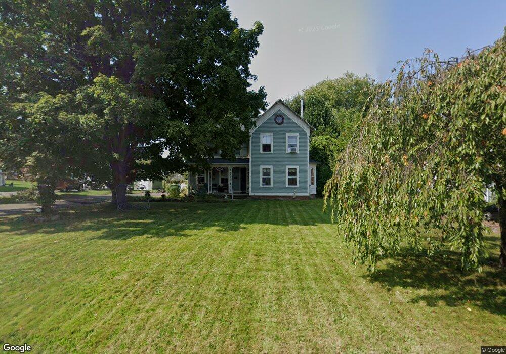
273 Farm Hill Rd Middletown, CT 06457
Estimated Value: $349,397 - $406,000
3
Beds
2
Baths
1,609
Sq Ft
$234/Sq Ft
Est. Value
About This Home
This home is located at 273 Farm Hill Rd, Middletown, CT 06457 and is currently estimated at $376,349, approximately $233 per square foot. 273 Farm Hill Rd is a home located in Middlesex County with nearby schools including Farm Hill School, Middletown High School, and St John Paul II School.
Ownership History
Date
Name
Owned For
Owner Type
Purchase Details
Closed on
Sep 4, 2015
Sold by
Diamond-Varni Heather
Bought by
Diamond-Varni Heather and Varni Louis
Current Estimated Value
Purchase Details
Closed on
Mar 31, 2000
Sold by
Fisher Glenn K and Fisher Audrey D
Bought by
Brown Jason M and Brown Heather L
Home Financials for this Owner
Home Financials are based on the most recent Mortgage that was taken out on this home.
Original Mortgage
$133,385
Interest Rate
8.4%
Create a Home Valuation Report for This Property
The Home Valuation Report is an in-depth analysis detailing your home's value as well as a comparison with similar homes in the area
Home Values in the Area
Average Home Value in this Area
Purchase History
| Date | Buyer | Sale Price | Title Company |
|---|---|---|---|
| Diamond-Varni Heather | -- | -- | |
| Brown Jason M | $134,500 | -- |
Source: Public Records
Mortgage History
| Date | Status | Borrower | Loan Amount |
|---|---|---|---|
| Previous Owner | Brown Jason M | $133,385 | |
| Previous Owner | Brown Jason M | $56,500 | |
| Previous Owner | Brown Jason M | $74,000 | |
| Previous Owner | Brown Jason M | $47,800 |
Source: Public Records
Tax History Compared to Growth
Tax History
| Year | Tax Paid | Tax Assessment Tax Assessment Total Assessment is a certain percentage of the fair market value that is determined by local assessors to be the total taxable value of land and additions on the property. | Land | Improvement |
|---|---|---|---|---|
| 2025 | $6,407 | $173,100 | $69,080 | $104,020 |
| 2024 | $6,130 | $173,100 | $69,080 | $104,020 |
| 2023 | $5,818 | $173,100 | $69,080 | $104,020 |
| 2022 | $5,248 | $127,220 | $46,050 | $81,170 |
| 2021 | $5,225 | $127,220 | $46,050 | $81,170 |
| 2020 | $5,216 | $127,220 | $46,050 | $81,170 |
| 2019 | $5,242 | $127,220 | $46,050 | $81,170 |
| 2018 | $5,061 | $127,220 | $46,050 | $81,170 |
| 2017 | $4,909 | $126,910 | $55,060 | $71,850 |
| 2016 | $4,811 | $126,910 | $55,060 | $71,850 |
| 2015 | $4,704 | $126,910 | $55,060 | $71,850 |
| 2014 | $4,700 | $126,910 | $55,060 | $71,850 |
Source: Public Records
Map
Nearby Homes
- 158 Newtown St
- 347 Farm Hill Rd
- 505 Hunting Hill Ave
- 50 Garfield Ave
- 0 Arbutus St Unit 24065180
- 64 Victoria Heights
- 66 Durant Terrace
- 58 Durant Terrace
- 10 Lorelei Cir
- 77 Lindsey Rd
- 126 Highland Ave
- 128 Highland Ave
- 80 Russell St
- 48 Overlook Ave
- 19 Fairlawn Ave
- 58 Jacobs Terrace
- 81 Dorothy Dr
- 154 Front St
- 100 Jack English Dr
- 1 Russell St Unit 11
- 259 Farm Hill Rd
- 285 Farm Hill Rd
- 90 Bielefield Rd
- 257 Farm Hill Rd
- 98 Bielefield Rd
- 84 Bielefield Rd
- 266 Farm Hill Rd
- 240 Newtown St
- 78 Bielefield Rd
- 272 Farm Hill Rd
- 282 Farm Hill Rd
- 23 Brookside Ave
- 297 Farm Hill Rd
- 70 Bielefield Rd
- 298 Farm Hill Rd
- 256 Farm Hill Rd
- 6 Milardo Ln
- 192 Newtown St
- 300 Farm Hill Rd
- 0 Milardo Ln Unit N294572