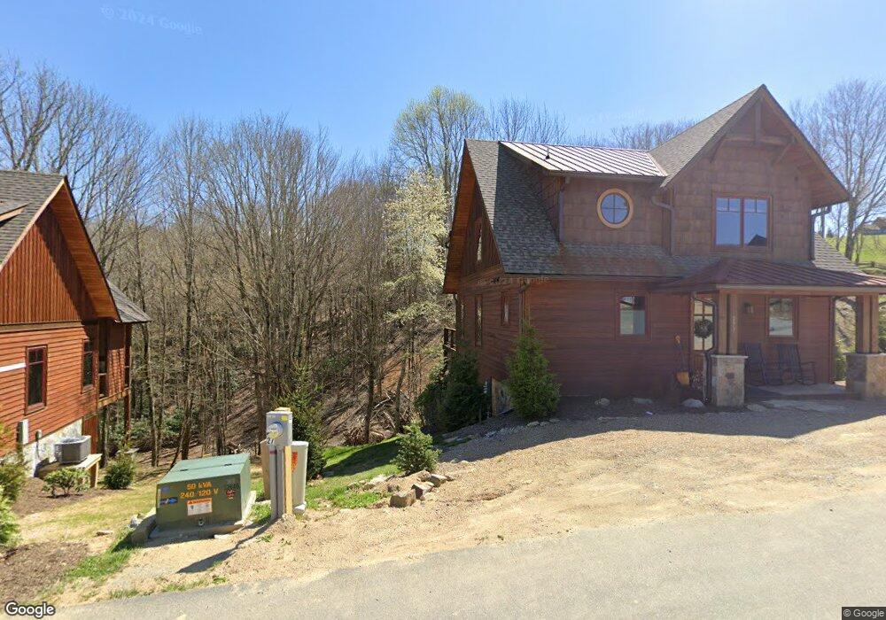
273 High Country Overlook Rd Banner Elk, NC 28604
Estimated Value: $1,025,000 - $1,134,000
3
Beds
3
Baths
1,666
Sq Ft
$652/Sq Ft
Est. Value
About This Home
This home is located at 273 High Country Overlook Rd, Banner Elk, NC 28604 and is currently estimated at $1,085,963, approximately $651 per square foot. 273 High Country Overlook Rd is a home with nearby schools including Freedom Trail Elementary School, Cranberry Middle School, and Avery County High School.
Ownership History
Date
Name
Owned For
Owner Type
Purchase Details
Closed on
Apr 13, 2023
Sold by
Hutto William N and Hutto Stacey S
Bought by
High Country Estates Llc
Current Estimated Value
Purchase Details
Closed on
Oct 5, 2022
Sold by
Stupp Jeffrey D and Stupp Dierdre M
Bought by
Hutto William N and Hutto Stacey S
Home Financials for this Owner
Home Financials are based on the most recent Mortgage that was taken out on this home.
Original Mortgage
$900,000
Interest Rate
5.25%
Mortgage Type
New Conventional
Purchase Details
Closed on
Dec 20, 2019
Sold by
Eagles Nest Holdings Llc
Bought by
Stupp Jeffrey D and Stupp Deirdre M
Home Financials for this Owner
Home Financials are based on the most recent Mortgage that was taken out on this home.
Original Mortgage
$451,872
Interest Rate
3.75%
Mortgage Type
Construction
Create a Home Valuation Report for This Property
The Home Valuation Report is an in-depth analysis detailing your home's value as well as a comparison with similar homes in the area
Home Values in the Area
Average Home Value in this Area
Purchase History
| Date | Buyer | Sale Price | Title Company |
|---|---|---|---|
| High Country Estates Llc | -- | None Listed On Document | |
| Hutto William N | $1,800 | -- | |
| Stupp Jeffrey D | $90,000 | None Available |
Source: Public Records
Mortgage History
| Date | Status | Borrower | Loan Amount |
|---|---|---|---|
| Previous Owner | Hutto William N | $900,000 | |
| Previous Owner | Stupp Jeffrey D | $451,872 |
Source: Public Records
Tax History Compared to Growth
Tax History
| Year | Tax Paid | Tax Assessment Tax Assessment Total Assessment is a certain percentage of the fair market value that is determined by local assessors to be the total taxable value of land and additions on the property. | Land | Improvement |
|---|---|---|---|---|
| 2024 | $3,197 | $756,300 | $150,000 | $606,300 |
| 2023 | $3,197 | $762,600 | $150,000 | $612,600 |
| 2022 | $3,197 | $762,600 | $150,000 | $612,600 |
| 2021 | $2,437 | $443,100 | $125,000 | $318,100 |
| 2020 | $688 | $125,001 | $125,000 | $1 |
| 2019 | $0 | $125,000 | $125,000 | $0 |
Source: Public Records
Map
Nearby Homes
- 303 High Country Overlook
- 273 High Country Overlook
- O-28 High Country Overlook
- 95 Vineyard Trail
- R-7 Eagle Camp Overlook
- 26 High Country Overlook
- VV-9 Vineyard Trail
- RS1 Skywest Pkwy
- 9 High Country Overlook
- 77 Eagles Nest Trail
- 0 Eagles Nest Trail
- RS7 Skywest Pkwy
- 47 Eagle Park Cir
- 91 Peregrine Trail
- RS4 Skywest Pkwy
- Lot 93 Peregrine Trail
- TBD Beech Mountain Rd
- VR1 Red Sky Pkwy
- F2 High Valley Overlook
- Lot 90 Eagles Nest Trail
- 1965 Old Beech Mountain Rd
- 330 High Country Overlook
- O 26 High Country Overlook
- VV13 Vineyard Trail
- 376 High Country Overlook
- lot O-20 Overlook
- 148 Sky Rock Path
- 34 Cabernet Ct
- 40 Vineyard Trail
- 138 Sky Rock Path
- 119 Sky Rock Path
- 28 Cabernet Ct
- 12 Vineyard Trail
- 13 Vineyard Trail
- VV2 Vineyard Trail
- VV2 Vineyard Trail Unit VV2
- TBD Vineyard Trail
- 6137 Eagles Nest Trail
- 58 High Valley Overlook
- 186 Vineyard Trail