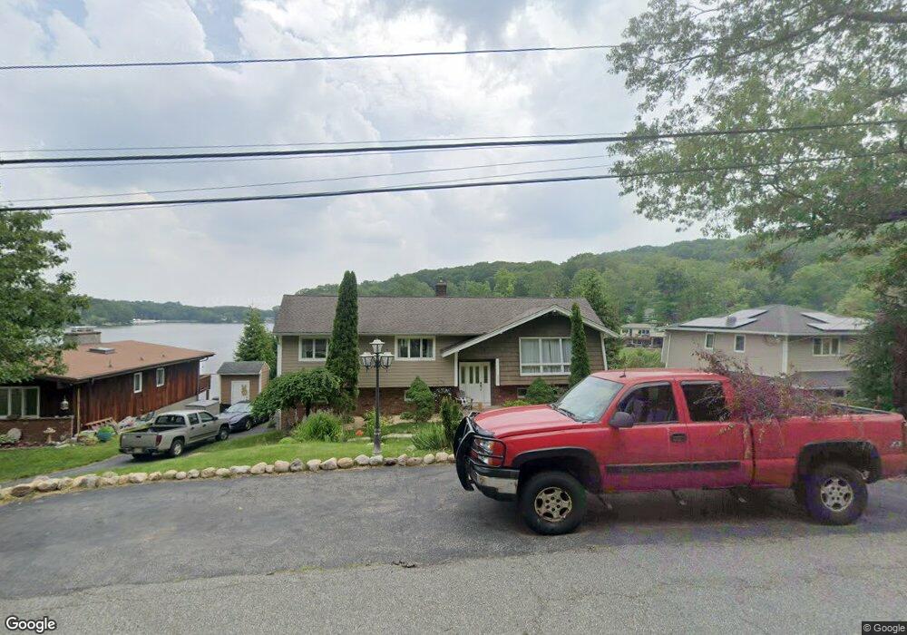
273 High Crest Dr West Milford, NJ 07480
Estimated Value: $597,050 - $704,000
--
Bed
--
Bath
2,060
Sq Ft
$313/Sq Ft
Est. Value
About This Home
This home is located at 273 High Crest Dr, West Milford, NJ 07480 and is currently estimated at $645,013, approximately $313 per square foot. 273 High Crest Dr is a home located in Passaic County with nearby schools including Macopin Middle School, West Milford High School, and Apple Montessori Schools and Camps - Kinnelon.
Ownership History
Date
Name
Owned For
Owner Type
Purchase Details
Closed on
May 28, 2009
Sold by
Demao Thomas and Demeo Thomas
Bought by
Demeo Thomas
Current Estimated Value
Home Financials for this Owner
Home Financials are based on the most recent Mortgage that was taken out on this home.
Original Mortgage
$313,390
Outstanding Balance
$198,644
Interest Rate
4.83%
Mortgage Type
Purchase Money Mortgage
Estimated Equity
$446,369
Purchase Details
Closed on
Apr 26, 2002
Sold by
Bowman Thomas
Bought by
Demao Thomas
Home Financials for this Owner
Home Financials are based on the most recent Mortgage that was taken out on this home.
Original Mortgage
$281,600
Interest Rate
6.73%
Create a Home Valuation Report for This Property
The Home Valuation Report is an in-depth analysis detailing your home's value as well as a comparison with similar homes in the area
Home Values in the Area
Average Home Value in this Area
Purchase History
| Date | Buyer | Sale Price | Title Company |
|---|---|---|---|
| Demeo Thomas | -- | -- | |
| Demao Thomas | $352,000 | -- |
Source: Public Records
Mortgage History
| Date | Status | Borrower | Loan Amount |
|---|---|---|---|
| Open | Demeo Thomas | $313,390 | |
| Previous Owner | Demao Thomas | $281,600 |
Source: Public Records
Tax History Compared to Growth
Tax History
| Year | Tax Paid | Tax Assessment Tax Assessment Total Assessment is a certain percentage of the fair market value that is determined by local assessors to be the total taxable value of land and additions on the property. | Land | Improvement |
|---|---|---|---|---|
| 2025 | $15,478 | $381,800 | $205,200 | $176,600 |
| 2024 | $15,558 | $381,800 | $205,200 | $176,600 |
| 2022 | $14,768 | $381,800 | $205,200 | $176,600 |
| 2021 | $14,451 | $381,800 | $205,200 | $176,600 |
| 2020 | $14,298 | $381,800 | $205,200 | $176,600 |
| 2019 | $14,108 | $381,800 | $205,200 | $176,600 |
| 2018 | $14,073 | $381,800 | $205,200 | $176,600 |
| 2017 | $14,138 | $381,800 | $205,200 | $176,600 |
| 2016 | $14,161 | $381,800 | $205,200 | $176,600 |
| 2015 | $13,997 | $381,800 | $205,200 | $176,600 |
| 2014 | $13,657 | $381,800 | $205,200 | $176,600 |
Source: Public Records
Map
Nearby Homes
- 13 Upper High Crest Dr
- 351 High Crest Dr
- 94 Upper High Crest Dr
- 15 Longview Rd
- 94 Up High Crest Rd
- 1858 New Jersey 23
- 1858 State Rt 23
- 128 Upper High Crest Dr
- 128 Up High Crest Rd
- 6 Mohawk Trail
- 577 MacOpin Rd
- 16 Berry Ln
- 34 North Rd
- 402 Cambridge Dr
- 474 Cambridge Dr
- 130 Barrister Dr
- 265 Winthrop Dr Unit 54
- 271 Winthrop Dr Unit 57
- 0 Oakwood Ave
- 2 Sheeprock Rd
- 269 High Crest Dr
- 277 High Crest Dr
- 267 High Crest Dr
- 281 High Crest Dr
- 263 High Crest Dr
- 280 High Crest Dr
- 285 High Crest Dr
- 274 High Crest Dr
- 299 High Crest Dr
- 303 High Crest Dr
- 293 High Crest Dr
- 284 High Crest Dr
- 259 High Crest Dr
- 260 High Crest Dr
- 309 High Crest Dr
- 257 High Crest Dr
- 250 High Crest Dr
- 313 High Crest Dr
- 290 High Crest Dr
- 302 High Crest Dr