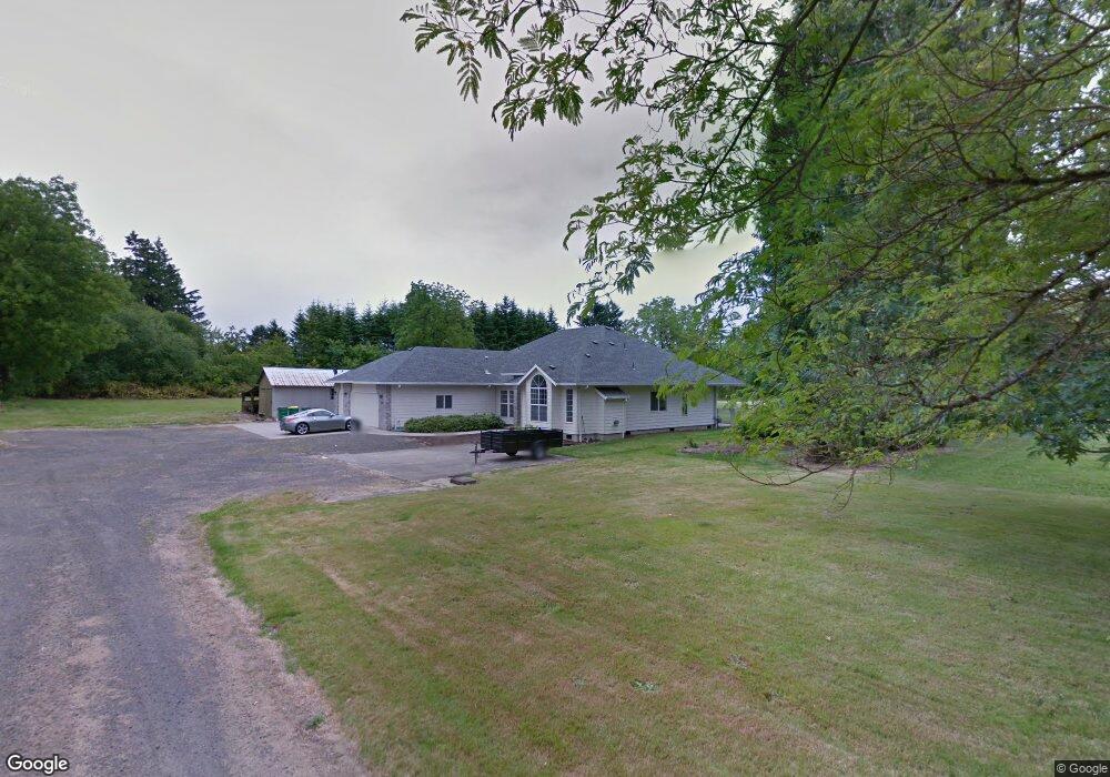
2731 Sunset Dr Forest Grove, OR 97116
Estimated Value: $488,000 - $850,000
3
Beds
3
Baths
2,403
Sq Ft
$299/Sq Ft
Est. Value
About This Home
This home is located at 2731 Sunset Dr, Forest Grove, OR 97116 and is currently estimated at $718,110, approximately $298 per square foot. 2731 Sunset Dr is a home located in Washington County with nearby schools including Fern Hill Elementary School, Tom McCall Upper Elementary School, and Neil Armstrong Middle School.
Ownership History
Date
Name
Owned For
Owner Type
Purchase Details
Closed on
Apr 19, 2012
Sold by
Maplewood Estates Llc
Bought by
Maplewood Estates Llc
Current Estimated Value
Home Financials for this Owner
Home Financials are based on the most recent Mortgage that was taken out on this home.
Original Mortgage
$296,000
Outstanding Balance
$202,304
Interest Rate
3.84%
Mortgage Type
New Conventional
Estimated Equity
$515,806
Purchase Details
Closed on
Apr 11, 2012
Sold by
Maplewood Estates Llc
Bought by
Anzaldi Larry A
Home Financials for this Owner
Home Financials are based on the most recent Mortgage that was taken out on this home.
Original Mortgage
$296,000
Outstanding Balance
$202,304
Interest Rate
3.84%
Mortgage Type
New Conventional
Estimated Equity
$515,806
Purchase Details
Closed on
Aug 16, 2007
Sold by
Gaona Kathy
Bought by
Maplewood Estates Llc
Create a Home Valuation Report for This Property
The Home Valuation Report is an in-depth analysis detailing your home's value as well as a comparison with similar homes in the area
Home Values in the Area
Average Home Value in this Area
Purchase History
| Date | Buyer | Sale Price | Title Company |
|---|---|---|---|
| Maplewood Estates Llc | -- | First American | |
| Anzaldi Larry A | $330,000 | First American | |
| Maplewood Estates Llc | $675,000 | Ticor Title |
Source: Public Records
Mortgage History
| Date | Status | Borrower | Loan Amount |
|---|---|---|---|
| Open | Anzaldi Larry A | $296,000 |
Source: Public Records
Tax History Compared to Growth
Tax History
| Year | Tax Paid | Tax Assessment Tax Assessment Total Assessment is a certain percentage of the fair market value that is determined by local assessors to be the total taxable value of land and additions on the property. | Land | Improvement |
|---|---|---|---|---|
| 2026 | $4,437 | $249,170 | -- | -- |
| 2025 | $4,437 | $241,920 | -- | -- |
| 2024 | $4,281 | $234,880 | -- | -- |
| 2023 | $4,281 | $228,040 | $0 | $0 |
| 2022 | $3,743 | $228,040 | $0 | $0 |
| 2021 | $3,695 | $214,960 | $0 | $0 |
| 2020 | $3,675 | $208,700 | $0 | $0 |
| 2019 | $3,593 | $202,630 | $0 | $0 |
| 2018 | $3,483 | $196,730 | $0 | $0 |
| 2017 | $3,375 | $191,000 | $0 | $0 |
| 2016 | $3,280 | $185,440 | $0 | $0 |
| 2015 | $3,154 | $180,040 | $0 | $0 |
| 2014 | $3,139 | $174,800 | $0 | $0 |
Source: Public Records
Map
Nearby Homes
- 2251 27th Ave
- 2443 26th Ave
- 904 Rosebud Ct
- Alder Plan at Parkview Terrace - Single-Family Homes
- Mattingly Plan at Parkview Terrace - Single-Family Homes
- Arleta Plan at Parkview Terrace - Paired Villas
- Moreland Plan at Parkview Terrace - Paired Villas
- Eason Plan at Parkview Terrace - Single-Family Homes
- Marivue Plan at Parkview Terrace - Paired Villas
- Albin Plan at Parkview Terrace - Single-Family Homes
- 916 Rosebud Ct
- Caden Plan at Parkview Terrace - Single-Family Homes
- 803 Misty Ln
- 801 Misty Ln
- 926 Rosebud Ct
- 807 Misty Ln
- Beekman Plan at Parkview Terrace - Single-Family Homes
- 2106 Charlie Ct
- 2715 28th Ave
- 2727 28th Ave