Estimated Value: $826,982 - $950,000
6
Beds
3
Baths
2,930
Sq Ft
$312/Sq Ft
Est. Value
About This Home
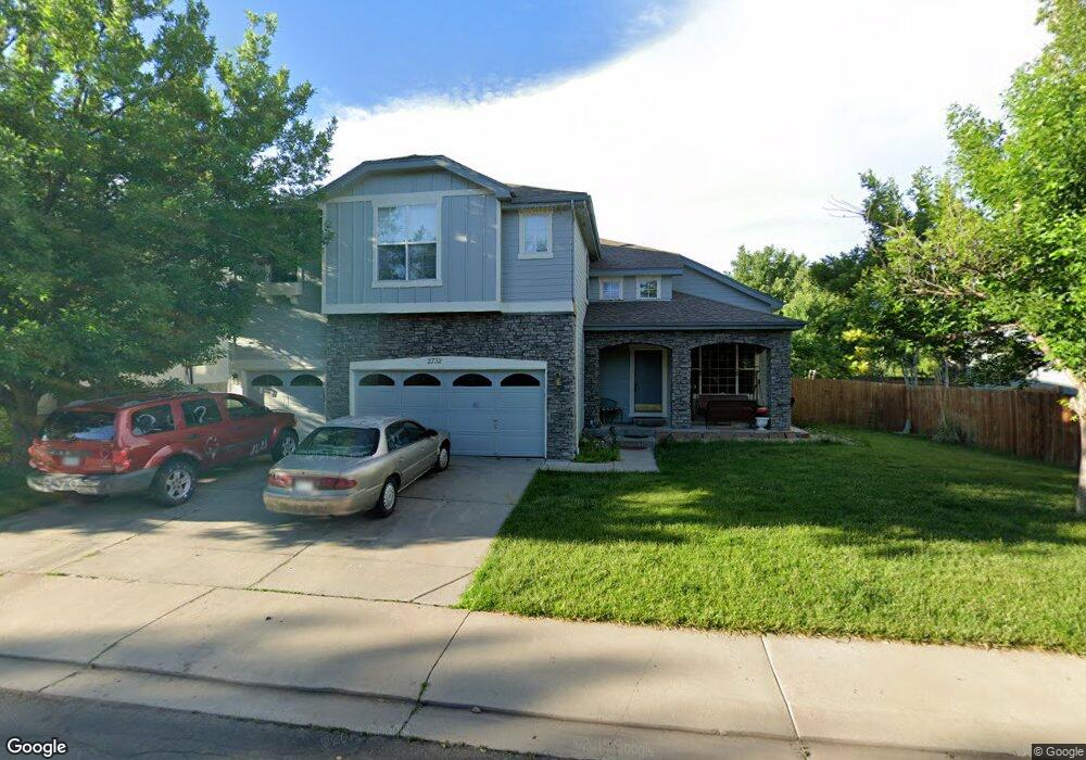
This home is located at 2732 Odell Dr, Erie, CO 80516 and is currently estimated at $914,246, approximately $312 per square foot. 2732 Odell Dr is a home located in Boulder County with nearby schools including Meadowlark School, Centaurus High School, and Aspen Ridge Preparatory School.
Ownership History
Date
Name
Owned For
Owner Type
Purchase Details
Closed on
Mar 14, 2003
Sold by
Lauck Stuart P and Haering Cynthia V
Bought by
Collier Carol Denise
Current Estimated Value
Home Financials for this Owner
Home Financials are based on the most recent Mortgage that was taken out on this home.
Original Mortgage
$294,000
Outstanding Balance
$112,405
Interest Rate
4.37%
Mortgage Type
Purchase Money Mortgage
Estimated Equity
$801,841
Purchase Details
Closed on
May 6, 1999
Sold by
Wl Homes Llc
Bought by
Lauck Stuart P
Home Financials for this Owner
Home Financials are based on the most recent Mortgage that was taken out on this home.
Original Mortgage
$235,550
Interest Rate
7.04%
Create a Home Valuation Report for This Property
The Home Valuation Report is an in-depth analysis detailing your home's value as well as a comparison with similar homes in the area
Home Values in the Area
Average Home Value in this Area
Purchase History
| Date | Buyer | Sale Price | Title Company |
|---|---|---|---|
| Collier Carol Denise | $367,500 | American Liberty Title | |
| Lauck Stuart P | $294,491 | -- |
Source: Public Records
Mortgage History
| Date | Status | Borrower | Loan Amount |
|---|---|---|---|
| Open | Collier Carol Denise | $294,000 | |
| Previous Owner | Lauck Stuart P | $235,550 |
Source: Public Records
Tax History Compared to Growth
Tax History
| Year | Tax Paid | Tax Assessment Tax Assessment Total Assessment is a certain percentage of the fair market value that is determined by local assessors to be the total taxable value of land and additions on the property. | Land | Improvement |
|---|---|---|---|---|
| 2025 | $5,335 | $49,713 | $12,863 | $36,850 |
| 2024 | $5,335 | $49,713 | $12,863 | $36,850 |
| 2023 | $5,258 | $50,545 | $17,112 | $37,118 |
| 2022 | $4,430 | $39,893 | $10,828 | $29,065 |
| 2021 | $4,419 | $41,041 | $11,140 | $29,901 |
| 2020 | $4,111 | $37,831 | $6,936 | $30,895 |
| 2019 | $4,060 | $37,831 | $6,936 | $30,895 |
| 2018 | $3,888 | $35,568 | $9,792 | $25,776 |
| 2017 | $3,657 | $39,323 | $10,826 | $28,497 |
| 2016 | $3,592 | $33,838 | $13,930 | $19,908 |
| 2015 | $3,946 | $27,796 | $8,358 | $19,438 |
| 2014 | $3,050 | $27,796 | $8,358 | $19,438 |
Source: Public Records
Map
Nearby Homes
- 1381 Siltstone St
- 1331 Fountain Ln
- 1842 Southard St
- 1195 Fox Hills Ct
- 848 Sandstone Cir
- 1321 Alexandria St
- 2326 Carbonate Cir
- 1063 Sandstone Cir
- 1305 Balmora St
- 1305 Inverness Dr
- 1920 Marfell St
- 972 Carbonate Ln
- 908 Dinosaur Dr
- 309 Baron Ave
- 825 Dakota Ln
- 2268 Front Range Rd
- 1182 Red Iron Ct
- 772 Carbonate Ln
- 1205 Red Iron Ct
- 304 W Beacon Hill Dr
- 2744 Odell Dr
- 2720 Odell Dr
- 1646 Woodward St
- 1611 Pickett Ct
- 2754 Odell Dr
- 2733 Odell Dr
- 1654 Woodward St
- 2725 Odell Dr
- 2741 Odell Dr
- 1621 Pickett Ct
- 2717 Odell Dr
- 2811 Prince Cir
- 1607 Woodward St
- 1595 Woodward St
- 1662 Woodward St
- 1621 Woodward St
- 2711 Odell Dr
- 1633 Woodward St
- 1629 Pickett Ct
- 2766 Odell Dr