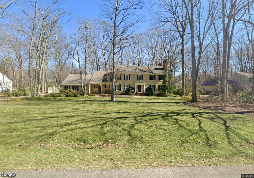
2735 Queenswood Rd Midlothian, VA 23113
Salisbury NeighborhoodEstimated Value: $795,548 - $838,000
4
Beds
4
Baths
3,536
Sq Ft
$231/Sq Ft
Est. Value
About This Home
This home is located at 2735 Queenswood Rd, Midlothian, VA 23113 and is currently estimated at $816,637, approximately $230 per square foot. 2735 Queenswood Rd is a home located in Chesterfield County with nearby schools including Bettie Weaver Elementary School, Midlothian Middle School, and Midlothian High School.
Ownership History
Date
Name
Owned For
Owner Type
Purchase Details
Closed on
Jan 18, 2001
Bought by
Huffman James A and Huffman Phyllis S
Current Estimated Value
Home Financials for this Owner
Home Financials are based on the most recent Mortgage that was taken out on this home.
Original Mortgage
$240,000
Outstanding Balance
$88,423
Interest Rate
7.52%
Mortgage Type
New Conventional
Estimated Equity
$728,214
Purchase Details
Closed on
Jan 13, 1997
Sold by
Towne Richard P
Bought by
Huffman James A and Huffman Phyllis S
Home Financials for this Owner
Home Financials are based on the most recent Mortgage that was taken out on this home.
Original Mortgage
$181,200
Interest Rate
7.46%
Mortgage Type
New Conventional
Create a Home Valuation Report for This Property
The Home Valuation Report is an in-depth analysis detailing your home's value as well as a comparison with similar homes in the area
Home Values in the Area
Average Home Value in this Area
Purchase History
| Date | Buyer | Sale Price | Title Company |
|---|---|---|---|
| Huffman James A | -- | -- | |
| Huffman James A | $226,500 | -- |
Source: Public Records
Mortgage History
| Date | Status | Borrower | Loan Amount |
|---|---|---|---|
| Open | Huffman James A | $240,000 | |
| Previous Owner | Huffman James A | $181,200 |
Source: Public Records
Tax History Compared to Growth
Tax History
| Year | Tax Paid | Tax Assessment Tax Assessment Total Assessment is a certain percentage of the fair market value that is determined by local assessors to be the total taxable value of land and additions on the property. | Land | Improvement |
|---|---|---|---|---|
| 2025 | $6,524 | $730,200 | $131,000 | $599,200 |
| 2024 | $6,524 | $680,400 | $111,000 | $569,400 |
| 2023 | $5,783 | $635,500 | $106,000 | $529,500 |
| 2022 | $5,431 | $590,300 | $103,000 | $487,300 |
| 2021 | $5,160 | $536,200 | $101,000 | $435,200 |
| 2020 | $4,916 | $517,500 | $101,000 | $416,500 |
| 2019 | $4,916 | $517,500 | $101,000 | $416,500 |
| 2018 | $4,743 | $499,300 | $101,000 | $398,300 |
| 2017 | $4,564 | $475,400 | $100,000 | $375,400 |
| 2016 | $4,537 | $472,600 | $96,000 | $376,600 |
| 2015 | $4,360 | $451,600 | $96,000 | $355,600 |
| 2014 | $4,241 | $439,200 | $96,000 | $343,200 |
Source: Public Records
Map
Nearby Homes
- 14110 Netherfield Dr
- 13901 Dunkeld Terrace
- 2810 Winterfield Rd
- 14302 Fulford Ct
- 2901 Mount Hill Dr
- 2631 Royal Crest Dr
- 14560 Kenmont Dr
- 14335 Lander Rd
- 2701 Cassaway Rd
- 2141 Chepstow Terrace
- 1185 Cardinal Crest Terrace
- 16033 Aspect Way
- 16037 Aspect Way
- 16116 Esteem Way
- 16112 Esteem Way
- 1175 Cardinal Crest Terrace
- 2100 Heathland Dr
- 3231 Queens Grant Dr
- 16213 Mabry Mill Dr
- 1813 Gildenborough Ct
- 2745 Queenswood Rd
- 2725 Queenswood Rd
- 14101 Grangewood Rd
- 2801 Queenswood Rd
- 2810 W Brigstock Rd
- 2820 W Brigstock Rd
- 2730 Queenswood Rd
- 14010 Helmsley Rd
- 2720 Queenswood Rd
- 2701 Queenswood Rd
- 2800 W Brigstock Rd
- 2830 W Brigstock Rd
- 14111 Grangewood Rd
- 2800 Queenswood Rd
- 2811 Queenswood Rd
- 2710 Queenswood Rd
- 14121 Grangewood Rd
- 2810 Queenswood Rd
- 2840 W Brigstock Rd
- 2601 Leafield Terrace