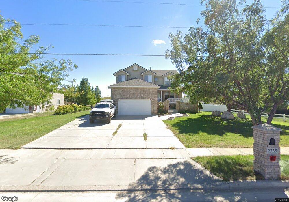
2735 W 2700 S Syracuse, UT 84075
Estimated Value: $572,000 - $668,826
5
Beds
4
Baths
3,115
Sq Ft
$201/Sq Ft
Est. Value
About This Home
This home is located at 2735 W 2700 S, Syracuse, UT 84075 and is currently estimated at $624,707, approximately $200 per square foot. 2735 W 2700 S is a home located in Davis County with nearby schools including Cook School, Legacy Junior High School, and Clearfield High School.
Ownership History
Date
Name
Owned For
Owner Type
Purchase Details
Closed on
May 2, 2019
Sold by
Fenn Philip
Bought by
Hegoas Brandon and Pine Juanita
Current Estimated Value
Home Financials for this Owner
Home Financials are based on the most recent Mortgage that was taken out on this home.
Original Mortgage
$389,900
Outstanding Balance
$342,094
Interest Rate
4.2%
Mortgage Type
VA
Estimated Equity
$282,613
Purchase Details
Closed on
Nov 13, 2013
Sold by
Henage Thomas E and Henage Emily A
Bought by
Penn Philip
Home Financials for this Owner
Home Financials are based on the most recent Mortgage that was taken out on this home.
Original Mortgage
$196,377
Interest Rate
5.5%
Mortgage Type
FHA
Purchase Details
Closed on
Dec 19, 2009
Sold by
Wood Saul M and Wood Cora Menudiado
Bought by
Henage Thomas E and Henage Emily A
Home Financials for this Owner
Home Financials are based on the most recent Mortgage that was taken out on this home.
Original Mortgage
$284,747
Interest Rate
4.87%
Mortgage Type
FHA
Purchase Details
Closed on
Apr 5, 2006
Sold by
Wells Fargo Bank Na
Bought by
Wood Saul M and Wood Cora Menudiado
Home Financials for this Owner
Home Financials are based on the most recent Mortgage that was taken out on this home.
Original Mortgage
$182,000
Interest Rate
6.35%
Mortgage Type
Fannie Mae Freddie Mac
Purchase Details
Closed on
Dec 15, 2005
Sold by
Simmons Steven W and Simmons Angela
Bought by
Wells Fargo Bank Na
Purchase Details
Closed on
May 31, 2002
Sold by
Simmons Steven W
Bought by
Simmons Steven W and Simmons Angela
Home Financials for this Owner
Home Financials are based on the most recent Mortgage that was taken out on this home.
Original Mortgage
$214,200
Interest Rate
7.2%
Purchase Details
Closed on
Sep 20, 1999
Sold by
Simmons Betty G
Bought by
Simmons Steven W
Home Financials for this Owner
Home Financials are based on the most recent Mortgage that was taken out on this home.
Original Mortgage
$150,000
Interest Rate
8.09%
Purchase Details
Closed on
Jul 28, 1997
Sold by
Simmons Betty G
Bought by
Simmons Betty G
Create a Home Valuation Report for This Property
The Home Valuation Report is an in-depth analysis detailing your home's value as well as a comparison with similar homes in the area
Home Values in the Area
Average Home Value in this Area
Purchase History
| Date | Buyer | Sale Price | Title Company |
|---|---|---|---|
| Hegoas Brandon | -- | First American Title | |
| Penn Philip | -- | Hickman Land Title Co | |
| Henage Thomas E | -- | First American Title | |
| Wood Saul M | -- | First American Title | |
| Wells Fargo Bank Na | $218,450 | Backman Title Services | |
| Simmons Steven W | -- | Bonneville Title Company Inc | |
| Simmons Steven W | -- | Bonneville Title Company Inc | |
| Simmons Betty G | -- | Bonneville Title Company Inc |
Source: Public Records
Mortgage History
| Date | Status | Borrower | Loan Amount |
|---|---|---|---|
| Open | Hegoas Brandon | $389,900 | |
| Previous Owner | Penn Philip | $196,377 | |
| Previous Owner | Henage Thomas E | $284,747 | |
| Previous Owner | Wood Saul M | $182,000 | |
| Previous Owner | Simmons Steven W | $214,200 | |
| Previous Owner | Simmons Steven W | $150,000 |
Source: Public Records
Tax History Compared to Growth
Tax History
| Year | Tax Paid | Tax Assessment Tax Assessment Total Assessment is a certain percentage of the fair market value that is determined by local assessors to be the total taxable value of land and additions on the property. | Land | Improvement |
|---|---|---|---|---|
| 2025 | -- | $341,550 | $101,855 | $239,695 |
| 2024 | -- | $322,300 | $94,133 | $228,167 |
| 2023 | $384 | $553,000 | $160,104 | $392,896 |
| 2022 | $384 | $321,200 | $89,504 | $231,696 |
| 2021 | $0 | $436,000 | $129,275 | $306,725 |
| 2020 | $2,215 | $374,000 | $115,409 | $258,591 |
| 2019 | $2,215 | $318,000 | $112,994 | $205,006 |
| 2018 | $2,183 | $311,000 | $106,410 | $204,590 |
| 2016 | $2,071 | $154,770 | $39,762 | $115,008 |
| 2015 | $2,022 | $143,880 | $39,762 | $104,118 |
| 2014 | $1,923 | $139,487 | $39,762 | $99,725 |
| 2013 | -- | $142,138 | $37,271 | $104,867 |
Source: Public Records
Map
Nearby Homes
- 2735 S Shoreline Dr
- 2726 2495 S Unit 205
- 2635 S 2430 W Unit 114
- 2971 S 2425 W Unit 1124
- 2625 S 2430 W Unit 112
- 2686 S 2440 W Unit 101
- 3062 W Solace St
- Bridgeport Plan at Sadie's Glenn
- Sullivan Plan at Sadie's Glenn
- Ashmore Plan at Sadie's Glenn
- Havenwood Plan at Sadie's Glenn
- Bradford Plan at Sadie's Glenn
- Sadie's Glen Plan at Sadie's Glenn
- Hamilton Plan at Sadie's Glenn
- Avery Plan at Sadie's Glenn
- Havenwood with Loft Plan at Sadie's Glenn
- Malan Plan at Sadie's Glenn
- 3006 S 2725 W
- 2996 S 2550 W
- 2402 W 2700 S