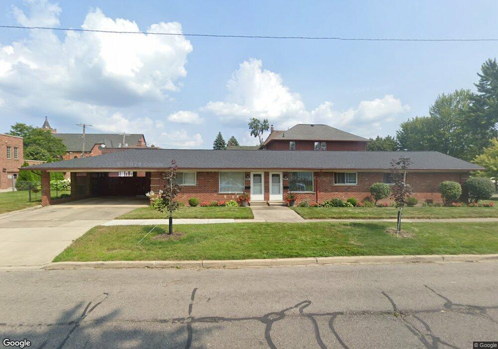
2737 2nd St Wyandotte, MI 48192
Estimated Value: $198,000 - $266,000
--
Bed
1
Bath
1,126
Sq Ft
$206/Sq Ft
Est. Value
About This Home
This home is located at 2737 2nd St, Wyandotte, MI 48192 and is currently estimated at $232,000, approximately $206 per square foot. 2737 2nd St is a home located in Wayne County with nearby schools including James A. Garfield Elementary School, Woodrow Wilson School, and Roosevelt High School.
Ownership History
Date
Name
Owned For
Owner Type
Purchase Details
Closed on
Oct 11, 2007
Sold by
Wells Fargo Bank Na
Bought by
City Of Wyandotte Municipal Corp
Current Estimated Value
Purchase Details
Closed on
Nov 24, 2006
Sold by
Option One Mortgage Corp
Bought by
Wells Fargo Bank Na and Merrill Lynch Mortgage Investors Trust M
Purchase Details
Closed on
Nov 22, 2006
Sold by
Rickrode Kimberly Ann and Powers Thomas
Bought by
Option One Mortgage Corp
Purchase Details
Closed on
Apr 11, 2001
Sold by
Rickrode Gerald
Bought by
Powers Kimberley A Rickrode
Create a Home Valuation Report for This Property
The Home Valuation Report is an in-depth analysis detailing your home's value as well as a comparison with similar homes in the area
Home Values in the Area
Average Home Value in this Area
Purchase History
| Date | Buyer | Sale Price | Title Company |
|---|---|---|---|
| City Of Wyandotte Municipal Corp | $50,000 | Attorneys Title Agency Llc | |
| Wells Fargo Bank Na | -- | None Available | |
| Option One Mortgage Corp | $59,500 | None Available | |
| Powers Kimberley A Rickrode | -- | -- |
Source: Public Records
Tax History Compared to Growth
Tax History
| Year | Tax Paid | Tax Assessment Tax Assessment Total Assessment is a certain percentage of the fair market value that is determined by local assessors to be the total taxable value of land and additions on the property. | Land | Improvement |
|---|---|---|---|---|
| 2025 | -- | $0 | $0 | $0 |
| 2024 | -- | $0 | $0 | $0 |
| 2023 | -- | $0 | $0 | $0 |
| 2022 | -- | $0 | $0 | $0 |
| 2021 | $0 | $0 | $0 | $0 |
| 2020 | $0 | $0 | $0 | $0 |
| 2019 | $0 | $0 | $0 | $0 |
| 2018 | $0 | $0 | $0 | $0 |
| 2017 | $0 | $0 | $0 | $0 |
| 2016 | $0 | $0 | $0 | $0 |
| 2015 | -- | $0 | $0 | $0 |
| 2013 | -- | $0 | $0 | $0 |
| 2012 | -- | $0 | $0 | $0 |
Source: Public Records
Map
Nearby Homes
- 225 Superior Blvd
- 166 Oak St
- 166 Oak St Unit 4
- 250 Chestnut St
- 2821 Biddle Ave Unit 38
- 2851 Biddle Ave
- 20 Chestnut St
- 20 Chestnut St Unit 401 & 408
- 2842 Van Alstyne St Unit 14
- 126 Poplar St
- 355 Poplar St
- 2619 5th St
- 117 Walnut St
- 532 Chestnut St
- 254 Cedar St
- 24 Kreger Dr
- 22 Kreger Dr
- 618 Walnut St
- 2116 Biddle Ave
- 1136 Superior Blvd
- 166 Chestnut St
- 154 Chestnut St
- 144 Chestnut St
- 204 Chestnut St
- 136 Chestnut St
- 218 Chestnut St
- 210 Chestnut St
- 232 Chestnut St
- 124 Chestnut St
- 2726 2nd St
- 203 Superior Blvd
- 211 Chestnut St
- 155 Chestnut St
- 215 Superior Blvd
- 145 Chestnut St
- 114 Chestnut St
- 2826 2nd St
- 234 Chestnut St
- 219 Superior Blvd
- 135 Superior Blvd