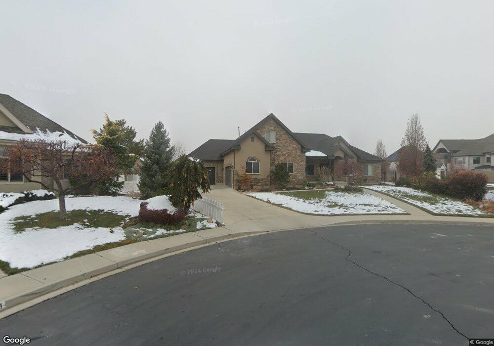
2737 N 1550 W Pleasant Grove, UT 84062
Estimated Value: $1,160,000 - $1,564,000
7
Beds
6
Baths
6,182
Sq Ft
$230/Sq Ft
Est. Value
About This Home
This home is located at 2737 N 1550 W, Pleasant Grove, UT 84062 and is currently estimated at $1,420,786, approximately $229 per square foot. 2737 N 1550 W is a home located in Utah County with nearby schools including Deerfield Elementary School, Mountain Ridge Junior High School, and American Fork High School.
Ownership History
Date
Name
Owned For
Owner Type
Purchase Details
Closed on
Aug 3, 2023
Sold by
Krull Anthony G and Krull Tawnya P
Bought by
Mefford Samuel and Mefford Brea
Current Estimated Value
Home Financials for this Owner
Home Financials are based on the most recent Mortgage that was taken out on this home.
Original Mortgage
$848,000
Outstanding Balance
$828,168
Interest Rate
6.67%
Mortgage Type
New Conventional
Estimated Equity
$592,618
Purchase Details
Closed on
Nov 10, 2021
Sold by
Greenwood Creek Llc
Bought by
Krull Anthony and Krull Tawyna
Purchase Details
Closed on
Apr 21, 2010
Sold by
Brems Aaron and Brems Kresha
Bought by
Krull Anthony G and Krull Tawnya P
Home Financials for this Owner
Home Financials are based on the most recent Mortgage that was taken out on this home.
Original Mortgage
$69,000
Interest Rate
4.91%
Mortgage Type
Purchase Money Mortgage
Purchase Details
Closed on
Aug 1, 2008
Sold by
Phelon Stephen W and Phelon Martha W
Bought by
Brems Aaron and Brems Kresha
Home Financials for this Owner
Home Financials are based on the most recent Mortgage that was taken out on this home.
Original Mortgage
$152,476
Interest Rate
6.41%
Mortgage Type
Purchase Money Mortgage
Purchase Details
Closed on
May 30, 2006
Sold by
Lpi Llc
Bought by
Phelon Stephen W and Phelon Martha W
Create a Home Valuation Report for This Property
The Home Valuation Report is an in-depth analysis detailing your home's value as well as a comparison with similar homes in the area
Home Values in the Area
Average Home Value in this Area
Purchase History
| Date | Buyer | Sale Price | Title Company |
|---|---|---|---|
| Mefford Samuel | -- | Cottonwood Title | |
| Krull Anthony | -- | Access Title | |
| Krull Anthony G | -- | Utah First Title Insurance | |
| Brems Aaron | -- | Utah First Title Insurance | |
| Phelon Stephen W | -- | First American Title Agency |
Source: Public Records
Mortgage History
| Date | Status | Borrower | Loan Amount |
|---|---|---|---|
| Open | Mefford Samuel | $848,000 | |
| Previous Owner | Krull Anthony G | $69,000 | |
| Previous Owner | Brems Aaron | $152,476 |
Source: Public Records
Tax History Compared to Growth
Tax History
| Year | Tax Paid | Tax Assessment Tax Assessment Total Assessment is a certain percentage of the fair market value that is determined by local assessors to be the total taxable value of land and additions on the property. | Land | Improvement |
|---|---|---|---|---|
| 2025 | $5,432 | $742,775 | $457,500 | $893,000 |
| 2024 | $4,408 | $633,875 | $0 | $0 |
| 2023 | $4,408 | $538,505 | $0 | $0 |
| 2022 | $4,538 | $551,705 | $0 | $0 |
| 2021 | $3,844 | $711,500 | $260,300 | $451,200 |
| 2020 | $3,631 | $658,800 | $241,000 | $417,800 |
| 2019 | $3,419 | $641,600 | $223,800 | $417,800 |
| 2018 | $3,465 | $614,800 | $206,600 | $408,200 |
| 2017 | $3,504 | $331,045 | $0 | $0 |
| 2016 | $3,282 | $299,310 | $0 | $0 |
| 2015 | $3,466 | $299,310 | $0 | $0 |
| 2014 | $3,349 | $286,495 | $0 | $0 |
Source: Public Records
Map
Nearby Homes
- 636 N 1280 E
- 2969 N 1350 W
- 649 N 1280 E
- 598 N 1280 E
- 1228 E 1030 N
- 1121 E 580 N
- 2254 N 1560 W
- 1162 E 1180 N
- 1058 N 930 E Unit 64
- 1045 N 930 E Unit 58
- The McKenzie Plan at Autumn Crest
- The Christine Plan at Autumn Crest
- The Avery Plan at Autumn Crest
- The Madison Plan at Autumn Crest
- The Roosevelt Plan at Autumn Crest
- The Annie Plan at Autumn Crest
- The Michelle Plan at Autumn Crest
- 1243 N 1270 E
- 1053 N 930 E Unit 73
- 1059 N 930 E
- 1542 W 2730 N
- 2711 N 1550 W
- 778 N 1300 E
- 782 N 1300 E
- 782 N 1300 E Unit 5
- 2809 N 1550 W
- 766 N 1300 E Unit LOT 3
- 763 N 1280 E
- 794 N 1300 E
- 2681 N 1550 W
- 1508 W 2730 N
- 2804 N 1550 W
- 2698 N 1550 W
- 754 N 1300 E Unit LOT 2
- 754 N 1300 E
- 826 N 1300 E
- 2839 N 1550 W Unit 6
- 2839 N 1550 W
- 2651 N 1550 W
- 732 N 1300 E