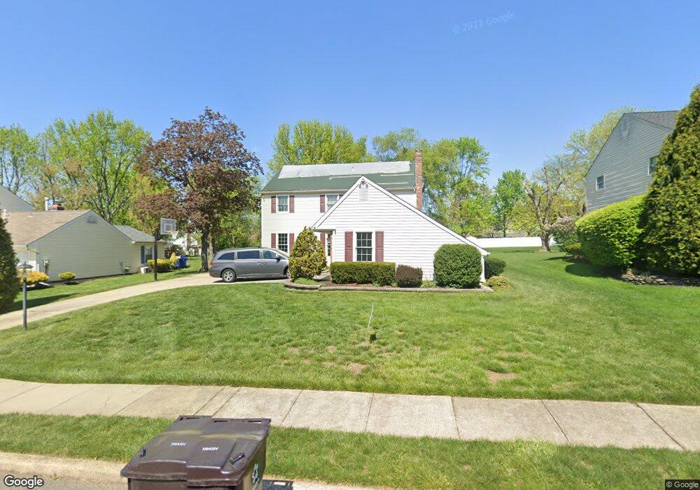
274 Burning Tree Rd Delran, NJ 08075
Tenby Chase NeighborhoodEstimated Value: $538,000 - $632,000
Studio
--
Bath
2,552
Sq Ft
$229/Sq Ft
Est. Value
About This Home
This home is located at 274 Burning Tree Rd, Delran, NJ 08075 and is currently estimated at $583,494, approximately $228 per square foot. 274 Burning Tree Rd is a home located in Burlington County with nearby schools including Millbridge Elementary School, Delran Intermediate School, and Delran Middle School.
Ownership History
Date
Name
Owned For
Owner Type
Purchase Details
Closed on
Sep 27, 2002
Sold by
Mcinerney Dennis P and Mcinerney Patricia C
Bought by
Flynn Bernard M and Flynn Ann
Current Estimated Value
Home Financials for this Owner
Home Financials are based on the most recent Mortgage that was taken out on this home.
Original Mortgage
$235,600
Interest Rate
5.65%
Create a Home Valuation Report for This Property
The Home Valuation Report is an in-depth analysis detailing your home's value as well as a comparison with similar homes in the area
Home Values in the Area
Average Home Value in this Area
Purchase History
| Date | Buyer | Sale Price | Title Company |
|---|---|---|---|
| Flynn Bernard M | $248,000 | Southern Counties Title Agen |
Source: Public Records
Mortgage History
| Date | Status | Borrower | Loan Amount |
|---|---|---|---|
| Closed | Flynn Bernard M | $235,600 |
Source: Public Records
Tax History
| Year | Tax Paid | Tax Assessment Tax Assessment Total Assessment is a certain percentage of the fair market value that is determined by local assessors to be the total taxable value of land and additions on the property. | Land | Improvement |
|---|---|---|---|---|
| 2025 | $11,769 | $296,000 | $65,000 | $231,000 |
| 2024 | $11,662 | $296,000 | $65,000 | $231,000 |
| 2023 | $11,662 | $296,000 | $65,000 | $231,000 |
| 2022 | $11,511 | $296,000 | $65,000 | $231,000 |
| 2021 | $11,509 | $296,000 | $65,000 | $231,000 |
| 2020 | $11,494 | $296,000 | $65,000 | $231,000 |
| 2019 | $11,387 | $296,000 | $65,000 | $231,000 |
| 2018 | $10,668 | $282,000 | $65,000 | $217,000 |
| 2017 | $10,499 | $282,000 | $65,000 | $217,000 |
| 2016 | $10,344 | $282,000 | $65,000 | $217,000 |
| 2015 | $10,172 | $282,000 | $65,000 | $217,000 |
| 2014 | $9,729 | $282,000 | $65,000 | $217,000 |
Source: Public Records
Map
Nearby Homes
- 139 Coopers Kill Rd
- 124 Coopers Kill Rd
- 247 Southview Dr
- 101 Tarlton Ct
- 120 Coopers Kill Rd
- 98 Red Stone Ridge
- 154 Fox Chase Dr
- 207 Farmington Rd
- 123 Shelly Ln
- 115 Haines Mill Rd
- 2211 Chestnut Hill Dr
- 100 Diane Ave
- 51 Suburban Blvd
- 2209 New Albany Rd
- 715 Willow Dr
- 108 Patricia Ave
- 23 Lehigh Dr
- 70 Suburban Blvd
- 347 Tom Brown Rd
- 343 Tom Brown Rd
- 276 Burning Tree Rd
- 272 Burning Tree Rd
- 829 Parry Rd
- 270 Burning Tree Rd
- 278 Burning Tree Rd
- 831 Parry Rd
- 275 Black Baron Dr
- 275 Burning Tree Rd
- 273 Burning Tree Rd
- 268 Burning Tree Rd
- 277 Burning Tree Rd
- 277 Black Baron Dr
- 271 Burning Tree Rd
- 230 Borton Mill Ct
- 279 Burning Tree Rd
- 271 Black Baron Dr
- 279 Black Baron Dr
- 273 Black Baron Dr
- 266 Burning Tree Rd
Your Personal Tour Guide
Ask me questions while you tour the home.