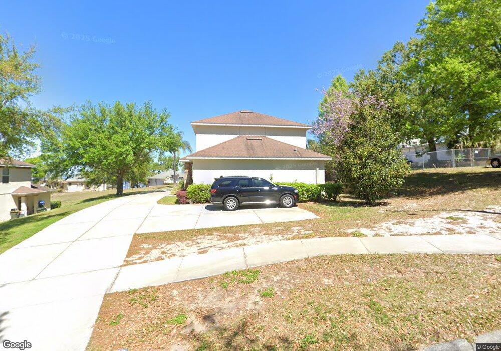
274 Cedar St Unit A Clermont, FL 34711
Estimated Value: $406,000 - $624,000
3
Beds
3
Baths
2,964
Sq Ft
$174/Sq Ft
Est. Value
About This Home
This home is located at 274 Cedar St Unit A, Clermont, FL 34711 and is currently estimated at $515,512, approximately $173 per square foot. 274 Cedar St Unit A is a home located in Lake County with nearby schools including Aurelia Cole Academy, South Lake High School, and Wesley Christian Academy.
Ownership History
Date
Name
Owned For
Owner Type
Purchase Details
Closed on
Aug 20, 2013
Sold by
Travis Diane
Bought by
Riley Star Properties Llc
Current Estimated Value
Purchase Details
Closed on
Oct 7, 2011
Sold by
Travis Diane
Bought by
Travis Diane
Purchase Details
Closed on
Jan 12, 2004
Sold by
Goring Thomas R and Goring Kellyann
Bought by
Woyte Thomas
Home Financials for this Owner
Home Financials are based on the most recent Mortgage that was taken out on this home.
Original Mortgage
$100,000
Interest Rate
5.87%
Mortgage Type
Commercial
Create a Home Valuation Report for This Property
The Home Valuation Report is an in-depth analysis detailing your home's value as well as a comparison with similar homes in the area
Purchase History
| Date | Buyer | Sale Price | Title Company |
|---|---|---|---|
| Riley Star Properties Llc | -- | None Available | |
| Riley Star Properties Llc | -- | None Available | |
| Travis Diane | -- | Attorney | |
| Travis Diane | -- | None Available | |
| Travis Diane | -- | Attorney | |
| Travis Diane | -- | None Available | |
| Woyte Thomas | $125,000 | -- | |
| Woyte Thomas | $125,000 | -- |
Source: Public Records
Mortgage History
| Date | Status | Borrower | Loan Amount |
|---|---|---|---|
| Previous Owner | Woyte Thomas | $100,000 |
Source: Public Records
Tax History
| Year | Tax Paid | Tax Assessment Tax Assessment Total Assessment is a certain percentage of the fair market value that is determined by local assessors to be the total taxable value of land and additions on the property. | Land | Improvement |
|---|---|---|---|---|
| 2026 | $6,156 | $415,668 | $112,500 | $303,168 |
| 2025 | $5,321 | $415,668 | $112,500 | $303,168 |
| 2024 | $5,321 | $415,668 | $112,500 | $303,168 |
| 2023 | $5,321 | $319,548 | $60,000 | $259,548 |
| 2022 | $4,914 | $299,548 | $40,000 | $259,548 |
| 2021 | $4,202 | $247,945 | $0 | $0 |
| 2020 | $4,109 | $240,649 | $0 | $0 |
| 2019 | $4,219 | $240,649 | $0 | $0 |
| 2018 | $3,730 | $211,464 | $0 | $0 |
| 2017 | $3,407 | $191,841 | $0 | $0 |
| 2016 | $3,471 | $191,841 | $0 | $0 |
| 2015 | $3,328 | $179,547 | $0 | $0 |
| 2014 | $2,960 | $161,590 | $0 | $0 |
Source: Public Records
Map
Nearby Homes
- 444 2nd St
- 214 W Osceola St
- 2411 Palm St
- 495 Carroll St
- 660 Shady Nook Dr
- 220 E Desoto St Unit 4
- 0 East Ave Unit MFRG5095417
- 241 Nautica Mile Dr
- 560 W Juniata St
- 152 Riggings Way
- 0 Roys Rd Unit MFRO6235691
- 0 E Minneola Ave
- 240 Division St
- 809 Disston Ave
- 629 Harbor Villa Ct
- 697 Winding Lake Dr
- 770 W Broome St
- 747/749 Pitt St
- 1271 6th St
- 408 Raymond St