Estimated Value: $383,000 - $443,000
4
Beds
3
Baths
2,345
Sq Ft
$174/Sq Ft
Est. Value
About This Home
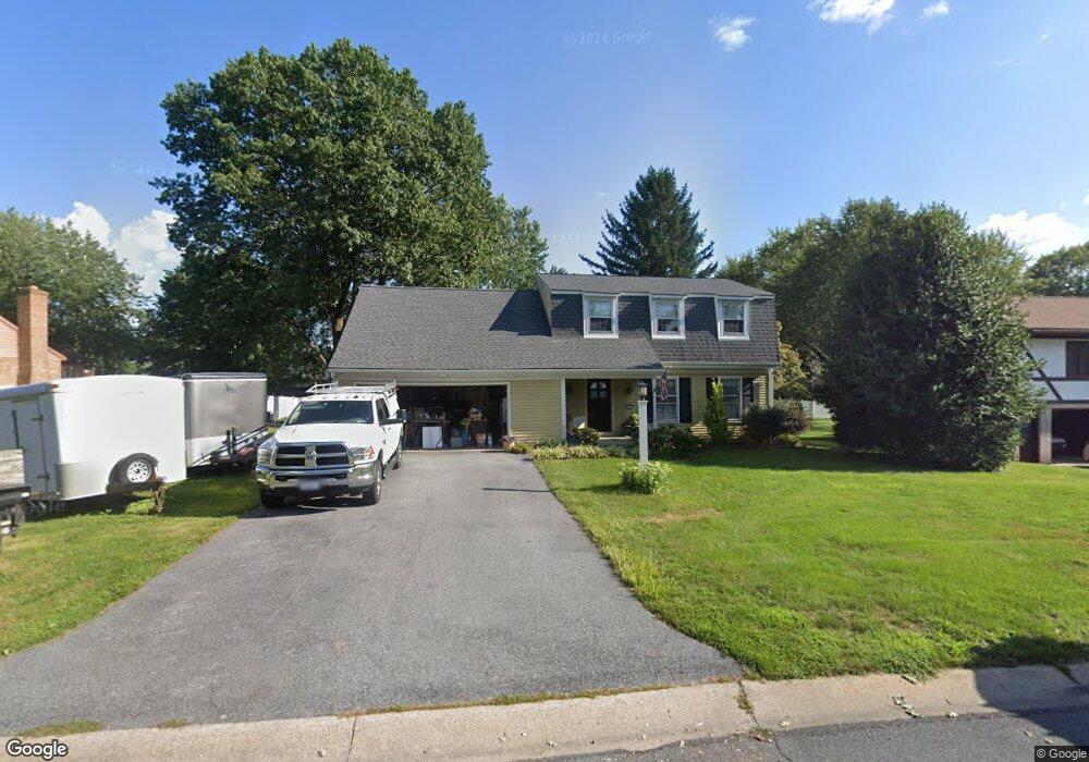
This home is located at 274 Robin Dale Dr, Leola, PA 17540 and is currently estimated at $408,085, approximately $174 per square foot. 274 Robin Dale Dr is a home located in Lancaster County with nearby schools including Brownstown El School, Gerald G. Huesken Middle School, and Conestoga Valley High School.
Ownership History
Date
Name
Owned For
Owner Type
Purchase Details
Closed on
Aug 16, 2021
Sold by
Leaman Carl E and Leaman Charlene K
Bought by
Fullard Aaron H and Vanderhorst Sintora R
Current Estimated Value
Home Financials for this Owner
Home Financials are based on the most recent Mortgage that was taken out on this home.
Original Mortgage
$135,000
Outstanding Balance
$122,757
Interest Rate
2.9%
Mortgage Type
New Conventional
Estimated Equity
$285,328
Purchase Details
Closed on
Nov 30, 2000
Sold by
Holtzapple John A and Holtzapple Nancy A
Bought by
Leaman Carl E and Leaman Charlene K
Home Financials for this Owner
Home Financials are based on the most recent Mortgage that was taken out on this home.
Original Mortgage
$90,000
Interest Rate
7.76%
Create a Home Valuation Report for This Property
The Home Valuation Report is an in-depth analysis detailing your home's value as well as a comparison with similar homes in the area
Home Values in the Area
Average Home Value in this Area
Purchase History
| Date | Buyer | Sale Price | Title Company |
|---|---|---|---|
| Fullard Aaron H | $300,000 | None Available | |
| Leaman Carl E | $165,000 | -- |
Source: Public Records
Mortgage History
| Date | Status | Borrower | Loan Amount |
|---|---|---|---|
| Open | Fullard Aaron H | $135,000 | |
| Previous Owner | Leaman Carl E | $90,000 |
Source: Public Records
Tax History Compared to Growth
Tax History
| Year | Tax Paid | Tax Assessment Tax Assessment Total Assessment is a certain percentage of the fair market value that is determined by local assessors to be the total taxable value of land and additions on the property. | Land | Improvement |
|---|---|---|---|---|
| 2025 | $4,162 | $209,100 | $68,700 | $140,400 |
| 2024 | $4,162 | $209,100 | $68,700 | $140,400 |
| 2023 | $4,064 | $209,100 | $68,700 | $140,400 |
| 2022 | $3,900 | $209,100 | $68,700 | $140,400 |
| 2021 | $3,758 | $209,100 | $68,700 | $140,400 |
| 2020 | $3,758 | $209,100 | $68,700 | $140,400 |
| 2019 | $3,674 | $209,100 | $68,700 | $140,400 |
| 2018 | $5,409 | $209,100 | $68,700 | $140,400 |
| 2017 | $3,561 | $167,600 | $41,300 | $126,300 |
| 2016 | $3,561 | $167,600 | $41,300 | $126,300 |
| 2015 | $892 | $167,600 | $41,300 | $126,300 |
| 2014 | $2,390 | $167,600 | $41,300 | $126,300 |
Source: Public Records
Map
Nearby Homes
- 248 E Main St
- 466 E Main St
- 456 Brendon Dr
- 39 N Maple Ave
- 68 Horseshoe Rd
- 753 Walnut St
- 71 Apricot Ave
- 322 Wissler Rd
- 259 Raspberry Rd
- 70 Hellers Church Rd
- 130 Snapdragon Dr
- 205 E Main St
- 80 Diller Ave Unit 9
- 41 Ashlea Village
- 220 Sycamore Ln
- 50 Allen Rd
- 227 Locust St
- 144 W Conestoga St
- 770 (rear lot) Maple Grove Rd
- 70 Millstone Dr
- 272 Robin Dale Dr
- 278 Robin Dale Dr
- 275 Willow Dell Ln
- 273 Willow Dell Ln
- 279 Willow Dell Ln
- 280 Robin Dale Dr
- 45 Country Side Ln
- 275 Robin Dale Dr
- 279 Robin Dale Dr
- 281 Willow Dell Ln
- 41 Country Side Ln
- 53 Country Side Ln
- 281 Robin Dale Dr
- 284 Robin Dale Dr
- 285 Willow Dell Ln
- 57 Country Side Ln
- 285 Robin Dale Dr
- 274 Willow Dell Ln
- 278 Willow Dell Ln
- 286 Robin Dale Dr