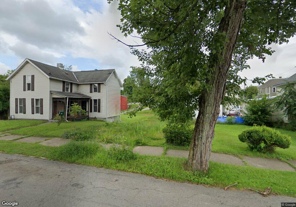
274 S Adams St Mansfield, OH 44902
Estimated Value: $60,000
2
Beds
1
Bath
640
Sq Ft
$94/Sq Ft
Est. Value
About This Home
This home is located at 274 S Adams St, Mansfield, OH 44902 and is currently priced at $60,000, approximately $93 per square foot. 274 S Adams St is a home located in Richland County with nearby schools including St. Peter's Elementary/Montessori School, St. Peter's High School/Junior High, and Discovery School.
Ownership History
Date
Name
Owned For
Owner Type
Purchase Details
Closed on
Oct 19, 2020
Sold by
Richland County Land Reutilization Corp
Bought by
Brown Roscoe J
Current Estimated Value
Purchase Details
Closed on
Sep 30, 2020
Sold by
Couny Of Richland
Bought by
Richland County Land Reutilization Corp
Purchase Details
Closed on
Oct 12, 2010
Sold by
Chung Joshua K and Chung Kay
Bought by
Jones Talbert S and Jones Bettie D
Purchase Details
Closed on
Oct 18, 2007
Sold by
Parsons Kimberly and Parsons James
Bought by
Chung Joshua K
Purchase Details
Closed on
Sep 29, 2005
Sold by
Fannie Mae
Bought by
Parsons Kimberly
Purchase Details
Closed on
Feb 16, 2005
Sold by
Hoffman Chris
Bought by
Fanniemae
Purchase Details
Closed on
Jan 6, 1994
Sold by
Vollmer John M
Bought by
Sharrock David R
Purchase Details
Closed on
Jan 1, 1985
Create a Home Valuation Report for This Property
The Home Valuation Report is an in-depth analysis detailing your home's value as well as a comparison with similar homes in the area
Home Values in the Area
Average Home Value in this Area
Purchase History
| Date | Buyer | Sale Price | Title Company |
|---|---|---|---|
| Brown Roscoe J | -- | None Available | |
| Richland County Land Reutilization Corp | -- | None Available | |
| Jones Talbert S | -- | Attorney | |
| Chung Joshua K | $1,600 | Barrister Lawyers Title | |
| Parsons Kimberly | $3,000 | Title First Agency Inc | |
| Fanniemae | $20,000 | -- | |
| Sharrock David R | $5,200 | -- | |
| -- | $10,000 | -- |
Source: Public Records
Tax History Compared to Growth
Tax History
| Year | Tax Paid | Tax Assessment Tax Assessment Total Assessment is a certain percentage of the fair market value that is determined by local assessors to be the total taxable value of land and additions on the property. | Land | Improvement |
|---|---|---|---|---|
| 2021 | $58 | $990 | $990 | $0 |
| 2020 | $58 | $990 | $990 | $0 |
| 2019 | $4,765 | $6,160 | $1,050 | $5,110 |
| 2018 | $307 | $6,160 | $1,050 | $5,110 |
| 2017 | $358 | $6,160 | $1,050 | $5,110 |
| 2016 | $331 | $3,530 | $1,490 | $2,040 |
| 2015 | $331 | $3,530 | $1,490 | $2,040 |
| 2014 | $215 | $3,530 | $1,490 | $2,040 |
| 2012 | $165 | $3,530 | $1,490 | $2,040 |
Source: Public Records
Map
Nearby Homes
- 319 Altamont Ave
- 327 Hammond Ave
- 188 S Franklin Ave
- 259 S Main St
- 286 S Main St
- 212 S Main St
- 0 N Adams St
- 394 S Main St
- 175 S Mulberry St
- 137 Lexington Ave
- 186 S Mulberry St
- 305 Home Ave
- 96 Glenwood Heights
- 519 S Diamond St
- 261 Superior St
- 430 Beethoven St
- 172 -172 1 2 Lexington Ave
- 120 Grover St
- 209 Second
- 69 Reba Ave
- 276 S Adams St
- 268 S Adams St
- 100 Dale Ave
- 280 S Adams St
- 94 Dale Ave
- 260 S Adams St
- 269 S Adams St
- 97 Dale Ave
- 291 S Diamond St Unit 293
- 305 S Diamond St Unit 307
- 285 S Adams St
- 273 S Adams St
- 277 S Adams St
- 261 S Adams St
- 93 Dale Ave
- 281 S Adams St
- 256 S Adams St
- 126 Dale Ave
- 259 S Adams St
- 289 S Adams St