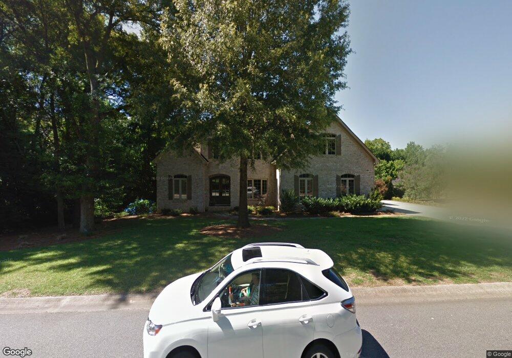
2743 Harlinsdale Dr Rock Hill, SC 29732
Estimated Value: $681,000 - $1,128,000
--
Bed
1
Bath
3,776
Sq Ft
$233/Sq Ft
Est. Value
About This Home
This home is located at 2743 Harlinsdale Dr, Rock Hill, SC 29732 and is currently estimated at $880,483, approximately $233 per square foot. 2743 Harlinsdale Dr is a home located in York County with nearby schools including India Hook Elementary School, Dutchman Creek Middle School, and Rock Hill High School.
Ownership History
Date
Name
Owned For
Owner Type
Purchase Details
Closed on
Sep 13, 2019
Sold by
Deese Christopher Jason and Deese Heather J
Bought by
Deese C Jason and Deese Heather J
Current Estimated Value
Purchase Details
Closed on
Jun 13, 2013
Sold by
Jenkins Martin L and Jenkins Eva R
Bought by
Deese Christopher J and Deese Heather
Home Financials for this Owner
Home Financials are based on the most recent Mortgage that was taken out on this home.
Original Mortgage
$388,000
Outstanding Balance
$276,492
Interest Rate
3.53%
Mortgage Type
New Conventional
Estimated Equity
$603,991
Purchase Details
Closed on
Oct 29, 2004
Sold by
First Land Co
Bought by
Jenkins Martin L and Jenkins Eva R
Purchase Details
Closed on
Dec 17, 1999
Sold by
Weekley Homes Lp
Bought by
Engle Kenneth W
Create a Home Valuation Report for This Property
The Home Valuation Report is an in-depth analysis detailing your home's value as well as a comparison with similar homes in the area
Home Values in the Area
Average Home Value in this Area
Purchase History
| Date | Buyer | Sale Price | Title Company |
|---|---|---|---|
| Deese C Jason | -- | None Available | |
| Deese Christopher J | $485,000 | -- | |
| Jenkins Martin L | $58,000 | -- | |
| Engle Kenneth W | $234,281 | -- |
Source: Public Records
Mortgage History
| Date | Status | Borrower | Loan Amount |
|---|---|---|---|
| Open | Deese Christopher J | $388,000 |
Source: Public Records
Tax History Compared to Growth
Tax History
| Year | Tax Paid | Tax Assessment Tax Assessment Total Assessment is a certain percentage of the fair market value that is determined by local assessors to be the total taxable value of land and additions on the property. | Land | Improvement |
|---|---|---|---|---|
| 2024 | $4,036 | $18,397 | $3,200 | $15,197 |
| 2023 | $4,047 | $18,397 | $3,200 | $15,197 |
| 2022 | $4,075 | $18,397 | $3,200 | $15,197 |
| 2021 | -- | $18,397 | $3,200 | $15,197 |
| 2020 | $4,084 | $18,397 | $0 | $0 |
| 2019 | $3,655 | $15,960 | $0 | $0 |
| 2018 | $3,650 | $15,960 | $0 | $0 |
| 2017 | $3,516 | $15,960 | $0 | $0 |
| 2016 | $3,484 | $15,960 | $0 | $0 |
| 2014 | $4,559 | $15,960 | $2,800 | $13,160 |
| 2013 | $4,559 | $17,420 | $2,800 | $14,620 |
Source: Public Records
Map
Nearby Homes
- 2733 Harlinsdale Dr
- 3708 Celanese Rd
- 962 Blakeley Walk
- 971 Blakeley Walk
- 800 Warrington Place
- 3110 India Hook Rd
- 1116 Torrington Cir
- 2972 Kaneland Ct
- 2971 Kaneland Ct
- 1845 Matthews Dr
- 2981 Ellington Dr
- 2832 Forest Hills Cir
- 2300 Crosstrail Ridge
- 2087 Poinsett Dr
- 1780 Lumpkin Cir
- 507 Birmingham Ct
- 1631 Wendover Ct
- 2020 Malvern Rd
- 666 Twin Lakes Rd
- 528 Chalmers Row
- 2758 Harlinsdale Dr
- 2733 Harlinsdale Dr Unit 2
- 2733 Harlinsdale Dr Unit 1
- 2733 Harlinsdale Dr Unit 1 and 2
- 2742 Harlinsdale Dr
- 2752 Harlinsdale Dr
- 2732 Harlinsdale Dr
- 2762 Harlinsdale Dr
- 2773 Harlinsdale Dr
- 2772 Harlinsdale Dr
- 2783 Harlinsdale Dr
- 2862 Harlinsdale Dr
- 2782 Harlinsdale Dr
- 2793 Harlinsdale Dr
- 2792 Harlinsdale Dr
- 2803 Harlinsdale Dr
- 722 Harbinger Rd
- 745 Harbinger Rd
- 2802 Harlinsdale Dr
- 2638 Claxton Dr