2746 Calvary Rd Crisfield, MD 21817
Estimated payment $2,672/month
Highlights
- 15,840 Feet of Waterfront
- 601.77 Acre Lot
- No HOA
About This Lot
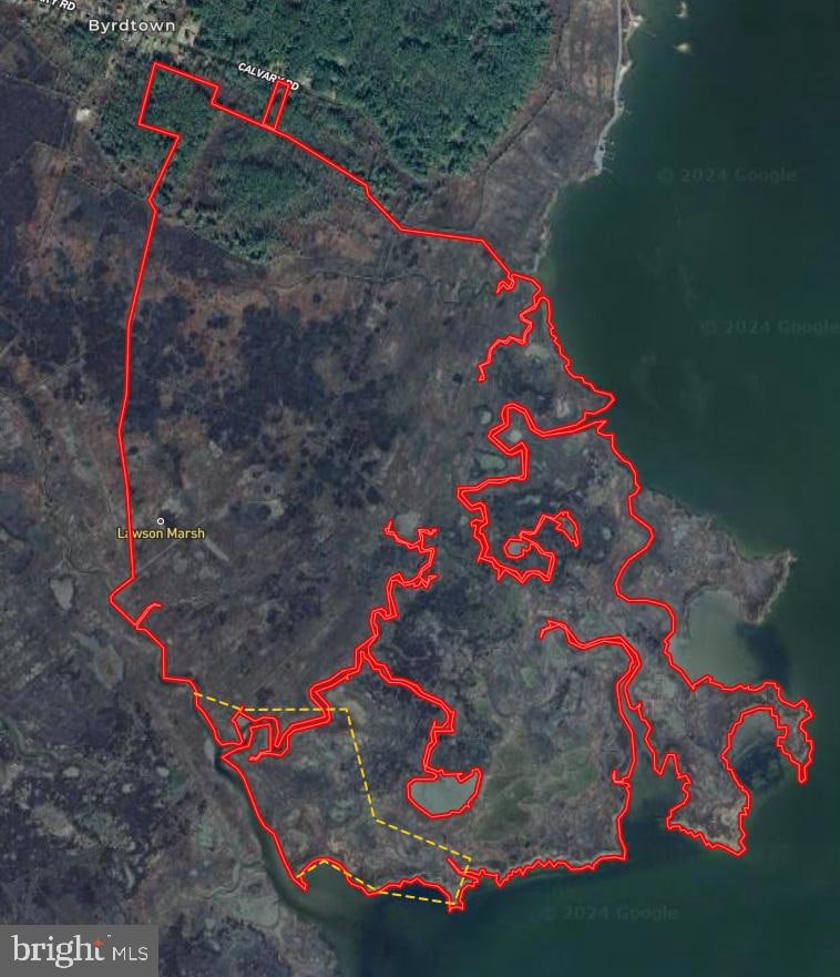
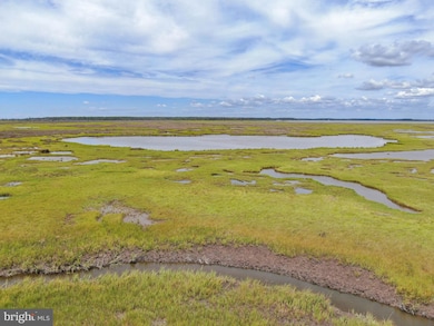
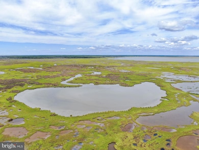
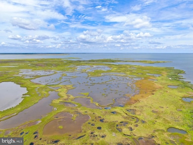
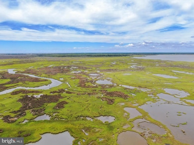
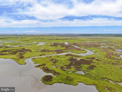
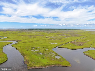
Presenting, Ware Point, Crisfield, Maryland - 601.77+- acres including a 0.77+- acre lot on Calvary Rd, 50+- acres of timber, and the remaining 551+- acres of salt marsh with over 3 miles of shoreline on the Pocomoke Sound and Ape Hole Creek. Please see video. Several creeks provide interior access to the interiors of Ware Point. The estuarine marsh is characterized by the typical flora that being salt hay (Spartina patens) on the high marsh and cord grass (Spartina alterniflora) on the lower parts of the marsh. A complex of 26 salt marsh ponds dominate the landscape of Ware Point. The habitat value of Ware Point is significant both today as it was in the mid-1900s when the Ward Brothers were perfecting their decoy carving craft along Jenkins Creek and the storied marsh known as Lawson Marsh immediately to the North of Ware Point. The salt marsh ponds, together with the complex of creeks and high marsh habitats, provide critical wintering habitat to wintering waterfowl throughout the migratory season. Today, the Pocomoke Sound ecosystem provides quality habitat to the Chesapeake Bay fishery where oysters, rockfish, and red fish are found throughout the depths of Ape Hole and small creeks leading into Ware Point. A conservation easement sponsored by The Lower Shore Land Trust allows you to place non-permanent structures such as sheds, duck blinds, and board walks to provide access and use of the property. Easement is attached herein. The marsh and timber is also accessible through the lot on Calvary Road. The timber is s a mix of hardwoods and pines, and suitable habitat for whitetail deer and other upland wildlife. On the lot is an old farmhouse of no value, sold "as-is and where-is". Availability of public sewer and approval for a well is subject to study by buyer during due diligence. Electric service to the property also requires approval from the utility company but is currently observable connected to the farmhouse. Quality of service to be verified by the Buyer. See Documents or Listing Agent for plats. Do not enter the property without permission - property is actively being hunted.
Listing Agent
(302) 448-9727 sue@thelandgroup.us National Land Realty, LLC License #679944 Listed on: 12/18/2024
Property Details
Property Type
- Land
Est. Annual Taxes
- $155
Lot Details
- 601.77 Acre Lot
- 15,840 Feet of Waterfront
- Home fronts navigable water
- Tax ID#12-000863
- Property is zoned MRC
Location
- Flood Risk
Utilities
- Well
- Public Hookup Available For Sewer
Listing and Financial Details
- Assessor Parcel Number 2012008384
Community Details
Overview
- No Home Owners Association
Recreation
- Water Access
- River Nearby
Map
Home Values in the Area
Average Home Value in this Area
Tax History
| Year | Tax Paid | Tax Assessment Tax Assessment Total Assessment is a certain percentage of the fair market value that is determined by local assessors to be the total taxable value of land and additions on the property. | Land | Improvement |
|---|---|---|---|---|
| 2025 | $454 | $20,400 | $16,300 | $4,100 |
| 2024 | $160 | $17,400 | $0 | $0 |
| 2023 | $160 | $14,400 | $0 | $0 |
| 2022 | $127 | $11,400 | $8,800 | $2,600 |
| 2021 | $0 | $11,400 | $8,800 | $2,600 |
| 2020 | $127 | $11,400 | $8,800 | $2,600 |
| 2019 | $270 | $24,300 | $18,800 | $5,500 |
| 2018 | $270 | $24,300 | $18,800 | $5,500 |
| 2017 | $270 | $24,300 | $0 | $0 |
| 2016 | $304 | $27,300 | $0 | $0 |
| 2015 | $304 | $27,300 | $0 | $0 |
| 2014 | $357 | $27,300 | $0 | $0 |
Property History
| Date | Event | Price | Change | Sq Ft Price |
|---|---|---|---|---|
| 02/21/2025 02/21/25 | Price Changed | $499,000 | -0.2% | -- |
| 12/18/2024 12/18/24 | For Sale | $500,000 | +4066.7% | -- |
| 12/15/2017 12/15/17 | Sold | $12,000 | -39.7% | $13 / Sq Ft |
| 12/06/2017 12/06/17 | Pending | -- | -- | -- |
| 05/25/2017 05/25/17 | For Sale | $19,900 | -- | $21 / Sq Ft |
Purchase History
| Date | Type | Sale Price | Title Company |
|---|---|---|---|
| Deed | $12,000 | None Available | |
| Interfamily Deed Transfer | -- | None Available | |
| Deed | $4,514 | -- | |
| Deed | $5,000 | -- |
Mortgage History
| Date | Status | Loan Amount | Loan Type |
|---|---|---|---|
| Closed | -- | No Value Available |
Source: Bright MLS
MLS Number: MDSO2005370
APN: 12-008384
Disclaimer: Certain information contained herein is derived from information provided by parties other than Homes.com. All information provided is deemed reliable, but is not guaranteed to be accurate and should be independently verified.
![]() The data relating to real estate for sale on this website appears in part through the BRIGHT Internet Data Exchange program, a voluntary cooperative exchange of property listing data between licensed real estate brokerage firms, and is provided by BRIGHT through a licensing agreement.
The data relating to real estate for sale on this website appears in part through the BRIGHT Internet Data Exchange program, a voluntary cooperative exchange of property listing data between licensed real estate brokerage firms, and is provided by BRIGHT through a licensing agreement.
Listing information is from various brokers who participate in the Bright MLS IDX program and not all listings may be visible on the site.
The property information being provided on or through the website is for the personal, non-commercial use of consumers and such information may not be used for any purpose other than to identify prospective properties consumers may be interested in purchasing.
Some properties which appear for sale on the website may no longer be available because they are for instance, under contract, sold or are no longer being offered for sale.
Property information displayed is deemed reliable but is not guaranteed.
Copyright 2025 Bright MLS, Inc.
- 0 Boone Rd Unit PARCEL 1370
- 0 Boone Rd Unit PARCEL 463
- 2877 Byrdtown Rd
- 2796 Calvary Rd
- 2894 Byrdtown Rd
- 2900 Ape Hole Rd
- 2990 Byrdtown Rd
- 2846 Calvary Rd
- 3012 William Maddox Rd
- Parcel 455 Boone Rd
- 3175 Boone Rd
- 26917 Clifton Mister Rd
- 3310 Lawsonia Rd
- 3231 Sackertown Rd
- 3289 Sackertown Rd
- 3288 Sackertown Rd
- 26813 Johnson Creek Rd
- 26830 Johnson Creek Rd
- 26545 Asbury Ave
- 26955 Johnson Creek Rd
- 407 Myrtle St
- 14290 Ridge Rd
- 20177 Allen Ln
- 31081 Temperanceville Rd
- 246 Morgans Ct
- 243 Morgans Ct
- 239 Morgans Ct
- 10800 Clipper Cir
- 16082 Cashville Rd
- 2921 Sheephouse Rd
- 33162 Chincoteague Rd
- 11779 Somerset Ave
- 11779 Somerset Ave
- 30630 Umes Blvd Unit H-304
- 14262 Shore Dr
- 28414 Woodland Ave
- Ave Real Norte Edif Golf Garden 1 Apt H1 Punta Cana Unit 1
- 30007 Killmon Ln
- 2252 Jolly Rodger Dr
- 37420 Neptune Dr
