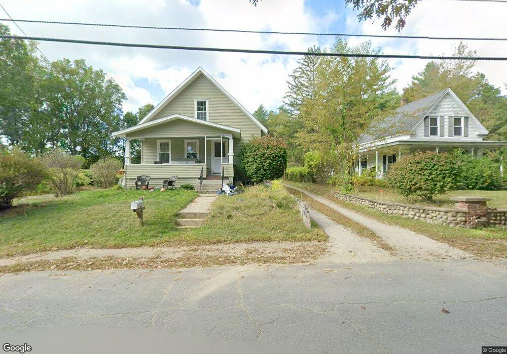
2748 N Main St Lancaster, MA 01523
Estimated Value: $387,000 - $417,000
2
Beds
1
Bath
936
Sq Ft
$426/Sq Ft
Est. Value
About This Home
This home is located at 2748 N Main St, Lancaster, MA 01523 and is currently estimated at $398,937, approximately $426 per square foot. 2748 N Main St is a home located in Worcester County with nearby schools including Mary Rowlandson Elementary School, Luther Burbank Middle School, and Nashoba Regional High School.
Ownership History
Date
Name
Owned For
Owner Type
Purchase Details
Closed on
Oct 20, 2010
Sold by
Cormier Deborah J and Wallace Mary A
Bought by
Mallette David J and Roach-Mallette Sheila A
Current Estimated Value
Home Financials for this Owner
Home Financials are based on the most recent Mortgage that was taken out on this home.
Original Mortgage
$110,000
Outstanding Balance
$72,378
Interest Rate
4.37%
Mortgage Type
Purchase Money Mortgage
Estimated Equity
$326,559
Create a Home Valuation Report for This Property
The Home Valuation Report is an in-depth analysis detailing your home's value as well as a comparison with similar homes in the area
Home Values in the Area
Average Home Value in this Area
Purchase History
| Date | Buyer | Sale Price | Title Company |
|---|---|---|---|
| Mallette David J | $140,000 | -- |
Source: Public Records
Mortgage History
| Date | Status | Borrower | Loan Amount |
|---|---|---|---|
| Open | Mallette David J | $110,000 |
Source: Public Records
Tax History Compared to Growth
Tax History
| Year | Tax Paid | Tax Assessment Tax Assessment Total Assessment is a certain percentage of the fair market value that is determined by local assessors to be the total taxable value of land and additions on the property. | Land | Improvement |
|---|---|---|---|---|
| 2025 | $3,833 | $237,200 | $96,900 | $140,300 |
| 2024 | $4,072 | $233,200 | $88,100 | $145,100 |
| 2023 | $3,512 | $204,300 | $80,100 | $124,200 |
| 2022 | $3,448 | $177,300 | $74,900 | $102,400 |
| 2021 | $3,329 | $166,600 | $74,900 | $91,700 |
| 2020 | $3,118 | $157,100 | $75,000 | $82,100 |
| 2019 | $2,994 | $151,600 | $75,000 | $76,600 |
| 2018 | $2,913 | $145,800 | $75,000 | $70,800 |
| 2016 | $2,733 | $139,800 | $74,200 | $65,600 |
| 2015 | $2,613 | $139,300 | $74,200 | $65,100 |
| 2014 | $2,572 | $136,000 | $74,200 | $61,800 |
Source: Public Records
Map
Nearby Homes
- 91 Berrington Rd Unit 91
- 97 Berrington Rd Unit 97
- 213 Bayberry Hill Ln
- 64 Sycamore Dr
- 12 Drummer Ln
- 50 Indian Ridge Dr
- 2237 Main St
- 851 Lancaster St
- 39 Legate Hill Rd
- 1237 Central St Unit 15
- 740 Central St Unit R24
- 740 Central St Unit L22
- 675 Willard St
- 23 Lantern Ln
- 35 Mcgovern Blvd
- 29 Wedgewood Ln
- 765 Brockelman Road Lot C
- 1497 Lunenburg Rd
- 30 Abbey Rd Unit 207
- 10 Abbey Rd Unit 108
- 2754 N Main St
- 2740 N Main St
- Lot 2 N Main St
- 0 N Main St
- 2741 N Main St
- 2731 N Main St
- 2725 N Main St
- 2713 N Main St
- 2790 N Main St Unit 2790
- 2790 N Main St
- 2790 N Main St Unit A
- 2790 N Main St Unit B
- 2790 N Main St Unit 1
- 2789 N Main St
- 2806 N Main St
- 2685 N Main St
- 2680 N Main St
- 2824 N Main St
- 2824 N Main St Unit 2
- 2677 N Main St