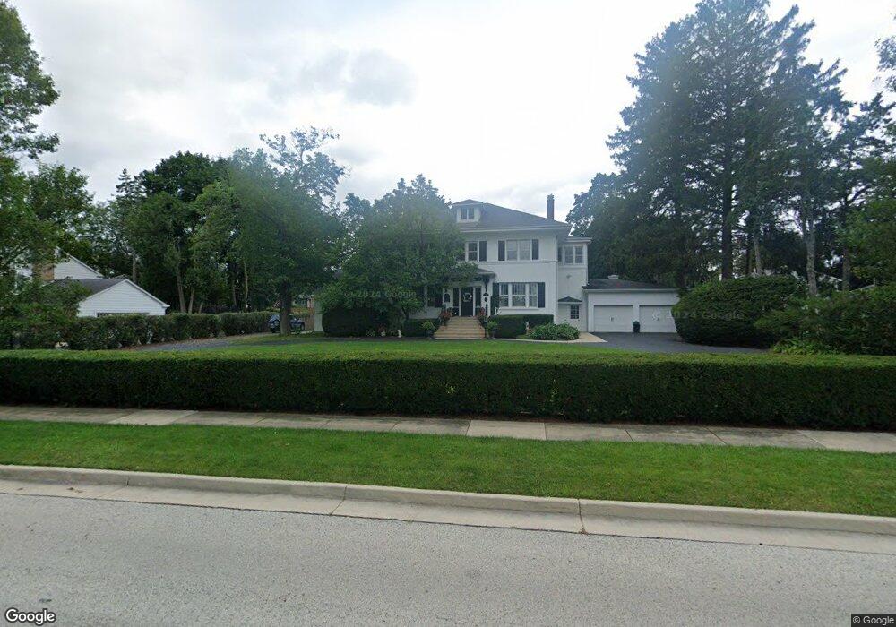
275 S Dymond Rd Libertyville, IL 60048
South Libertyville NeighborhoodEstimated Value: $1,068,000 - $1,143,000
--
Bed
4
Baths
4,030
Sq Ft
$274/Sq Ft
Est. Value
About This Home
This home is located at 275 S Dymond Rd, Libertyville, IL 60048 and is currently estimated at $1,103,659, approximately $273 per square foot. 275 S Dymond Rd is a home located in Lake County with nearby schools including Rockland Elementary School, Highland Middle School, and Libertyville High School.
Ownership History
Date
Name
Owned For
Owner Type
Purchase Details
Closed on
Nov 30, 2000
Sold by
Beck Stanley H and Beck Charlotte J
Bought by
Potts Stephen P and Potts Michelle C
Current Estimated Value
Home Financials for this Owner
Home Financials are based on the most recent Mortgage that was taken out on this home.
Original Mortgage
$540,000
Outstanding Balance
$199,998
Interest Rate
7.77%
Estimated Equity
$903,661
Create a Home Valuation Report for This Property
The Home Valuation Report is an in-depth analysis detailing your home's value as well as a comparison with similar homes in the area
Home Values in the Area
Average Home Value in this Area
Purchase History
| Date | Buyer | Sale Price | Title Company |
|---|---|---|---|
| Potts Stephen P | $675,000 | -- |
Source: Public Records
Mortgage History
| Date | Status | Borrower | Loan Amount |
|---|---|---|---|
| Open | Potts Stephen P | $540,000 |
Source: Public Records
Tax History Compared to Growth
Tax History
| Year | Tax Paid | Tax Assessment Tax Assessment Total Assessment is a certain percentage of the fair market value that is determined by local assessors to be the total taxable value of land and additions on the property. | Land | Improvement |
|---|---|---|---|---|
| 2024 | $18,397 | $256,341 | $91,724 | $164,617 |
| 2023 | $18,397 | $236,434 | $84,601 | $151,833 |
| 2022 | $18,725 | $240,136 | $81,317 | $158,819 |
| 2021 | $18,033 | $234,967 | $79,567 | $155,400 |
| 2020 | $17,358 | $231,016 | $78,229 | $152,787 |
| 2019 | $16,926 | $228,819 | $77,485 | $151,334 |
| 2018 | $16,337 | $228,373 | $77,848 | $150,525 |
| 2017 | $16,113 | $221,163 | $75,390 | $145,773 |
| 2016 | $15,588 | $209,693 | $71,480 | $138,213 |
| 2015 | $15,460 | $195,993 | $66,810 | $129,183 |
| 2014 | $15,738 | $195,463 | $67,121 | $128,342 |
| 2012 | $15,184 | $197,158 | $67,703 | $129,455 |
Source: Public Records
Map
Nearby Homes
- 1137 Pine Tree Ln
- 533 Drake St
- 1330 W Park Ave
- 223 Kenloch Ave
- 551 W Park Ave Unit E
- 423 Ames St
- 20924 & 20902 W Park Ave
- 0 Ames St
- 308 Mckinley Ave
- 777 Garfield Ave Unit A
- 747 Garfield Ave Unit C
- 1754 Glenmore Rd
- 420 W Cook Ave
- 505 Lange Ct
- 212 Elm Ct
- 851 Garfield Ave Unit C
- 1017 Juniper Pkwy
- 323 W Golf Rd
- 832 Interlaken Ln
- 426 S Milwaukee Ave
- 399 S Dymond Rd
- 1044 Gracewood Dr
- 379 Havenwood Ct
- 1038 Gracewood Dr
- 373 Havenwood Ct
- 1004 Havenwood Ln
- 385 Havenwood Ct
- 1032 Gracewood Dr
- 1010 Havenwood Ln
- 244 S Dymond Rd
- 1002 Gracewood Dr
- 1008 Gracewood Dr
- 1014 Gracewood Dr
- 300 S Dymond Rd
- 1026 Gracewood Dr
- 1020 Gracewood Dr
- 391 Havenwood Ct
- 985 Burridge St
- 1116 Pinetree Ln
- 1114 Pinetree Ln