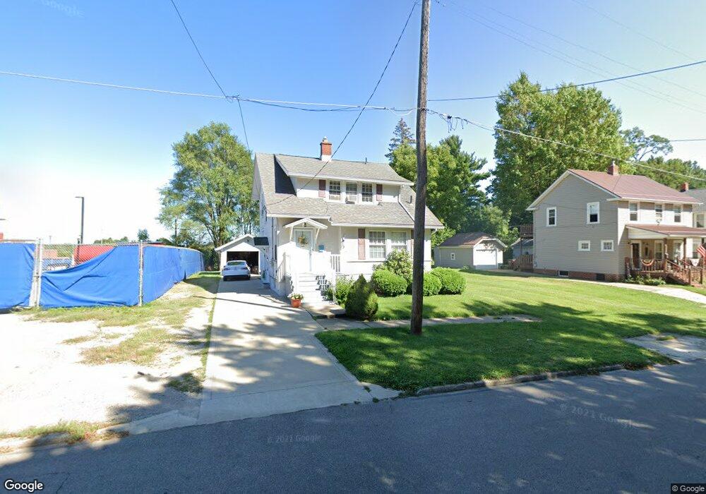
275 Vennum Ave Mansfield, OH 44903
Estimated Value: $95,719 - $109,000
3
Beds
1
Bath
1,496
Sq Ft
$68/Sq Ft
Est. Value
About This Home
This home is located at 275 Vennum Ave, Mansfield, OH 44903 and is currently estimated at $101,430, approximately $67 per square foot. 275 Vennum Ave is a home located in Richland County with nearby schools including St. Peter's Elementary/Montessori School, Discovery School, and St. Peter's Junior High / High School.
Ownership History
Date
Name
Owned For
Owner Type
Purchase Details
Closed on
Feb 15, 2017
Sold by
Jones Donna F
Bought by
Jones Donna F and Parish Lessie M
Current Estimated Value
Purchase Details
Closed on
Sep 26, 2000
Sold by
Est George M Steffey
Bought by
Jones Donna F
Home Financials for this Owner
Home Financials are based on the most recent Mortgage that was taken out on this home.
Original Mortgage
$52,300
Interest Rate
8.05%
Mortgage Type
New Conventional
Create a Home Valuation Report for This Property
The Home Valuation Report is an in-depth analysis detailing your home's value as well as a comparison with similar homes in the area
Home Values in the Area
Average Home Value in this Area
Purchase History
| Date | Buyer | Sale Price | Title Company |
|---|---|---|---|
| Jones Donna F | -- | None Available | |
| Jones Donna F | $54,000 | -- |
Source: Public Records
Mortgage History
| Date | Status | Borrower | Loan Amount |
|---|---|---|---|
| Previous Owner | Jones Donna F | $52,300 |
Source: Public Records
Tax History
| Year | Tax Paid | Tax Assessment Tax Assessment Total Assessment is a certain percentage of the fair market value that is determined by local assessors to be the total taxable value of land and additions on the property. | Land | Improvement |
|---|---|---|---|---|
| 2024 | $879 | $19,200 | $2,660 | $16,540 |
| 2023 | $440 | $19,200 | $2,660 | $16,540 |
| 2022 | $254 | $13,290 | $2,160 | $11,130 |
| 2021 | $255 | $13,290 | $2,160 | $11,130 |
| 2020 | $261 | $13,290 | $2,160 | $11,130 |
| 2019 | $289 | $13,290 | $2,160 | $11,130 |
| 2018 | $286 | $13,290 | $2,160 | $11,130 |
| 2017 | $278 | $13,290 | $2,160 | $11,130 |
| 2016 | $732 | $20,350 | $2,880 | $17,470 |
| 2015 | $699 | $20,350 | $2,880 | $17,470 |
| 2014 | $690 | $20,350 | $2,880 | $17,470 |
| 2012 | $287 | $21,420 | $3,030 | $18,390 |
Source: Public Records
Map
Nearby Homes
- 282 Vennum Ave
- 487 Davey Ave
- 455 Marion Ave
- 158 Vennum Ave
- 119 Carpenter Rd
- 310 Townview Cir N
- 135 Wood St
- 341 Townview Cir N
- 189 Westwood Ave
- 0 Cline Ave Hedeen Abbeyfeale Unit 9066362
- 616 Cline Ave
- 133 Stewart Ave S
- 151 Grover St
- 116 Stewart Ave S
- 131 Sturges Ave
- 108 Stewart Ave S
- 30 Douglas Ave
- 31 Bartley Ave
- 219 Lexington Ave
- 679 Coleman Rd
Your Personal Tour Guide
Ask me questions while you tour the home.