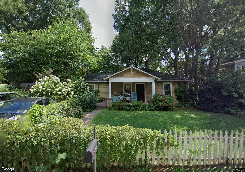
2759 Craigie Ave Decatur, GA 30030
Estimated Value: $388,479 - $533,000
3
Beds
2
Baths
1,209
Sq Ft
$383/Sq Ft
Est. Value
About This Home
This home is located at 2759 Craigie Ave, Decatur, GA 30030 and is currently estimated at $462,620, approximately $382 per square foot. 2759 Craigie Ave is a home located in DeKalb County with nearby schools including Avondale Elementary School, Druid Hills Middle School, and Druid Hills High School.
Ownership History
Date
Name
Owned For
Owner Type
Purchase Details
Closed on
Sep 25, 1998
Sold by
Dekalb Decatur Craigie Ave
Bought by
Cannon John and Cannon Oliver A
Current Estimated Value
Home Financials for this Owner
Home Financials are based on the most recent Mortgage that was taken out on this home.
Original Mortgage
$116,800
Outstanding Balance
$29,704
Interest Rate
8.75%
Mortgage Type
New Conventional
Estimated Equity
$432,916
Purchase Details
Closed on
Oct 31, 1995
Sold by
Babinsky I F
Bought by
Miller Mickey L
Create a Home Valuation Report for This Property
The Home Valuation Report is an in-depth analysis detailing your home's value as well as a comparison with similar homes in the area
Home Values in the Area
Average Home Value in this Area
Purchase History
| Date | Buyer | Sale Price | Title Company |
|---|---|---|---|
| Cannon John | $146,000 | -- | |
| Miller Mickey L | $53,000 | -- |
Source: Public Records
Mortgage History
| Date | Status | Borrower | Loan Amount |
|---|---|---|---|
| Open | Cannon John | $116,800 |
Source: Public Records
Tax History Compared to Growth
Tax History
| Year | Tax Paid | Tax Assessment Tax Assessment Total Assessment is a certain percentage of the fair market value that is determined by local assessors to be the total taxable value of land and additions on the property. | Land | Improvement |
|---|---|---|---|---|
| 2024 | $4,225 | $148,840 | $51,760 | $97,080 |
| 2023 | $4,225 | $147,480 | $46,080 | $101,400 |
| 2022 | $4,115 | $146,280 | $44,000 | $102,280 |
| 2021 | $3,779 | $131,720 | $44,000 | $87,720 |
| 2020 | $3,679 | $127,200 | $44,000 | $83,200 |
| 2019 | $3,805 | $133,720 | $44,000 | $89,720 |
| 2018 | $3,230 | $114,280 | $16,200 | $98,080 |
| 2017 | $3,291 | $107,600 | $16,200 | $91,400 |
| 2016 | $3,074 | $100,640 | $16,200 | $84,440 |
| 2014 | $2,295 | $68,000 | $16,160 | $51,840 |
Source: Public Records
Map
Nearby Homes
- 2773 Craigie Ave
- 874 Ashwood Walk
- 725 Brown Place
- 827 Derrydown Way
- 2829 Ashwood Place
- 847 Regal Path Ln
- 2630 Talley St Unit 326
- 2630 Talley St Unit 106
- 2839 Ashbury Heights Rd
- 230 New St Unit 2201-47
- 230 New St Unit 2201-4
- 2600 Talley St
- Olmstead Plan at New Talley Station - Stacks
- Dalton Plan at New Talley Station - Stacks
- McKoy Plan at New Talley Station - Stacks
- 451 S Columbia Dr
- 958 Forrest Blvd
- 201 New St Unit 2304-105
- 201 New St Unit 2304-1
- 201 New St Unit 2203-1
- 2763 Craigie Ave
- 2753 Craigie Ave
- 2764 Royal Bluff
- 2758 Royal Bluff
- 2768 Royal Bluff
- 2769 Craigie Ave
- 2754 Royal Bluff
- 2747 Craigie Ave
- 2758 Craigie Ave
- 2762 Craigie Ave
- 2772 Royal Bluff
- 2750 Royal Bluff
- 2748 Craigie Ave
- 2768 Craigie Ave
- 2776 Royal Bluff
- 2744 Craigie Ave
- 2746 Royal Bluff
- 2777 Craigie Ave
- 783 Brown Place
- 2739 Craigie Ave