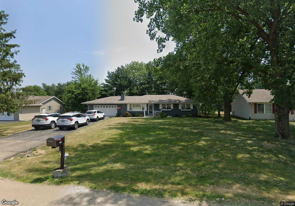
2759 N Deer Path Cir Oregon, IL 61061
Estimated Value: $201,827 - $263,000
Studio
--
Bath
1,344
Sq Ft
$174/Sq Ft
Est. Value
About This Home
This home is located at 2759 N Deer Path Cir, Oregon, IL 61061 and is currently estimated at $234,457, approximately $174 per square foot. 2759 N Deer Path Cir is a home located in Ogle County with nearby schools including Oregon Elementary School and Oregon High School.
Ownership History
Date
Name
Owned For
Owner Type
Purchase Details
Closed on
Oct 18, 2006
Sold by
Egyed Robert A and Egyed Maricia R
Bought by
Egyed Robert A and Egyed Marcia R
Current Estimated Value
Home Financials for this Owner
Home Financials are based on the most recent Mortgage that was taken out on this home.
Original Mortgage
$33,000
Interest Rate
6%
Mortgage Type
Stand Alone Second
Create a Home Valuation Report for This Property
The Home Valuation Report is an in-depth analysis detailing your home's value as well as a comparison with similar homes in the area
Home Values in the Area
Average Home Value in this Area
Purchase History
| Date | Buyer | Sale Price | Title Company |
|---|---|---|---|
| Egyed Robert A | -- | Stewart Title Co |
Source: Public Records
Mortgage History
| Date | Status | Borrower | Loan Amount |
|---|---|---|---|
| Closed | Egyed Robert A | $33,000 | |
| Open | Egyed Robert A | $132,000 |
Source: Public Records
Tax History
| Year | Tax Paid | Tax Assessment Tax Assessment Total Assessment is a certain percentage of the fair market value that is determined by local assessors to be the total taxable value of land and additions on the property. | Land | Improvement |
|---|---|---|---|---|
| 2024 | $4,533 | $58,719 | $10,333 | $48,386 |
| 2023 | $3,996 | $53,639 | $9,439 | $44,200 |
| 2022 | $3,918 | $51,094 | $8,991 | $42,103 |
| 2021 | $3,835 | $49,930 | $8,786 | $41,144 |
| 2020 | $3,677 | $47,689 | $8,392 | $39,297 |
| 2019 | $3,495 | $45,745 | $8,050 | $37,695 |
| 2018 | $3,405 | $45,745 | $8,050 | $37,695 |
| 2017 | $3,240 | $44,041 | $7,750 | $36,291 |
| 2016 | $3,172 | $43,394 | $7,636 | $35,758 |
| 2015 | $3,062 | $42,418 | $7,464 | $34,954 |
| 2014 | $3,052 | $42,418 | $7,464 | $34,954 |
| 2013 | $3,164 | $43,870 | $7,719 | $36,151 |
Source: Public Records
Map
Nearby Homes
- 1203 W Mud Creek Rd
- 000 Silver Ridge Dr
- 2422 N River Rd
- 0 N Il Rt 2 Unit 202506208
- 0 N Il Rt 2 Unit MRD12481307
- 0 N Il Rt 2 Unit 25126463
- 1101 E Spring Creek
- 959 N River Rd
- 754 E Equestrian Pointe Dr
- 754 E Equestrian Pointe Dr
- 1000 Illinois St
- 990 Illinois St
- 980 Illinois St
- 410 Lillemor Ln
- 404 Lillemor Ln
- 405 Lillemor Ln
- 400 Lillemor Ln
- 400 N 4th St
- 106 Mix St
- 311 N 4th St
- 1194 W Mud Creek Rd
- 2754 N Deer Path Cir
- 2749 N Deer Path Cir
- 2763 N Deer Path Cir
- 2760 N Deer Path Cir
- 2739 N Deer Path Cir
- 1426 W Indian Heights Dr
- 2748 N Deer Path Cir
- 1220 W Soli Dr
- 1312 W Indian Heights Dr
- 1247 W Soli Dr
- 1296 W Indian Heights Dr
- 2735 N Deer Path Cir
- 2734 N Deer Path Cir
- 2757 N Fawn Ridge Cir
- 1280 W Indian Heights Dr
- 1364 W Indian Heights Dr
- 2766 N Indian Heights Dr
- 2730 N Deer Path Cir
- 1258 W Indian Heights Dr
Your Personal Tour Guide
Ask me questions while you tour the home.