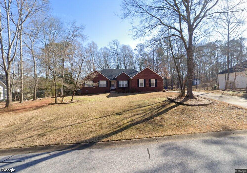
276 Imperial Way Bogart, GA 30622
Estimated Value: $377,000 - $404,000
--
Bed
1
Bath
1,967
Sq Ft
$197/Sq Ft
Est. Value
About This Home
This home is located at 276 Imperial Way, Bogart, GA 30622 and is currently estimated at $388,398, approximately $197 per square foot. 276 Imperial Way is a home located in Clarke County with nearby schools including Cleveland Road Elementary School, Burney-Harris-Lyons Middle School, and Clarke Central High School.
Ownership History
Date
Name
Owned For
Owner Type
Purchase Details
Closed on
Jan 12, 2012
Sold by
Pollock Jack Edwin
Bought by
Pollock Lori P
Current Estimated Value
Purchase Details
Closed on
Nov 24, 1999
Sold by
Robbie Gonterman Construction Inc
Bought by
Pollock Jack Edwin and Pollock Lori P
Purchase Details
Closed on
Jul 22, 1999
Sold by
Beech Haven Baptist Church Inc
Bought by
Robbie Gonterman Construction Inc
Create a Home Valuation Report for This Property
The Home Valuation Report is an in-depth analysis detailing your home's value as well as a comparison with similar homes in the area
Home Values in the Area
Average Home Value in this Area
Purchase History
| Date | Buyer | Sale Price | Title Company |
|---|---|---|---|
| Pollock Lori P | -- | -- | |
| Pollock Jack Edwin | $149,900 | -- | |
| Robbie Gonterman Construction Inc | $17,000 | -- |
Source: Public Records
Tax History Compared to Growth
Tax History
| Year | Tax Paid | Tax Assessment Tax Assessment Total Assessment is a certain percentage of the fair market value that is determined by local assessors to be the total taxable value of land and additions on the property. | Land | Improvement |
|---|---|---|---|---|
| 2025 | $3,506 | $130,928 | $18,000 | $112,928 |
| 2024 | $3,506 | $125,654 | $18,000 | $107,654 |
| 2023 | $3,427 | $119,375 | $18,000 | $101,375 |
| 2022 | $3,032 | $105,043 | $18,000 | $87,043 |
| 2021 | $2,607 | $87,366 | $16,000 | $71,366 |
| 2020 | $2,532 | $85,138 | $16,000 | $69,138 |
| 2019 | $2,305 | $77,880 | $16,000 | $61,880 |
| 2018 | $2,197 | $74,716 | $16,000 | $58,716 |
| 2017 | $2,047 | $70,296 | $16,000 | $54,296 |
| 2016 | $1,994 | $68,722 | $16,000 | $52,722 |
| 2015 | $1,929 | $66,720 | $16,000 | $50,720 |
| 2014 | $2,038 | $69,836 | $16,000 | $53,836 |
Source: Public Records
Map
Nearby Homes
- 682 Chesterfield Rd
- 240 W Huntington Rd
- 190 W Huntington Rd
- 212 Huntington Shoals Dr
- 141 Huntington Shoals Dr
- 241 Meeler Cir
- 575 Vaughn Rd
- 637 Huntington Rd Unit B1
- 100 Hanover Dr
- 256 Cherokee Ridge
- 532 Huntington Rd Unit 7
- 470 Huntington Rd Unit 5
- 215 Claystone Trace
- 450 River Bottom Rd
- 240 Deerfield Rd
- 112 Deerhollow Rd
- 115 Woodhaven St
- 266 Imperial Way
- 491 Chesterfield Rd
- 481 Chesterfield Rd
- 471 Chesterfield Rd
- 279 Imperial Way
- 501 Chesterfield Rd
- 256 Imperial Way
- 269 Imperial Way
- 461 Chesterfield Rd
- 110 Regent Ct
- 249 Imperial Way
- 451 Chesterfield Rd
- 511 Chesterfield Rd
- 246 Imperial Way
- 100 Regent Ct
- 184 Brittany Rd
- 174 Brittany Rd
- 239 Imperial Way
- 0 Regent Ct Unit 7263643
- 521 Chesterfield Rd