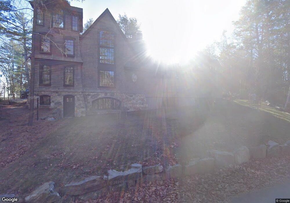
276 Little John Rd Yarmouth, ME 04096
Cousins Island NeighborhoodEstimated Value: $1,302,000 - $1,525,000
4
Beds
5
Baths
1,702
Sq Ft
$855/Sq Ft
Est. Value
About This Home
This home is located at 276 Little John Rd, Yarmouth, ME 04096 and is currently estimated at $1,455,083, approximately $854 per square foot. 276 Little John Rd is a home located in Cumberland County with nearby schools including William H. Rowe School, Yarmouth Elementary School, and Frank H. Harrison Middle School.
Ownership History
Date
Name
Owned For
Owner Type
Purchase Details
Closed on
Jun 12, 2017
Sold by
Waltman Leslie and Waltman Joseph
Bought by
Waltman Leslie B and Waltman Catherine R
Current Estimated Value
Create a Home Valuation Report for This Property
The Home Valuation Report is an in-depth analysis detailing your home's value as well as a comparison with similar homes in the area
Home Values in the Area
Average Home Value in this Area
Purchase History
| Date | Buyer | Sale Price | Title Company |
|---|---|---|---|
| Waltman Leslie B | -- | -- |
Source: Public Records
Tax History Compared to Growth
Tax History
| Year | Tax Paid | Tax Assessment Tax Assessment Total Assessment is a certain percentage of the fair market value that is determined by local assessors to be the total taxable value of land and additions on the property. | Land | Improvement |
|---|---|---|---|---|
| 2024 | $15,081 | $587,500 | $141,900 | $445,600 |
| 2023 | $13,830 | $587,500 | $141,900 | $445,600 |
| 2022 | $12,702 | $587,500 | $141,900 | $445,600 |
| 2021 | $11,633 | $587,500 | $141,900 | $445,600 |
| 2020 | $11,417 | $582,500 | $141,900 | $440,600 |
| 2019 | $10,986 | $582,500 | $141,900 | $440,600 |
| 2018 | $6,752 | $379,300 | $127,700 | $251,600 |
| 2017 | $2,363 | $137,700 | $127,700 | $10,000 |
| 2016 | $2,179 | $127,700 | $127,700 | $0 |
| 2015 | $6,091 | $282,500 | $100,900 | $181,600 |
| 2014 | $6,102 | $282,500 | $100,900 | $181,600 |
| 2013 | $222 | $10,100 | $0 | $0 |
Source: Public Records
Map
Nearby Homes
- 275 Littlejohn Rd
- 87 Wharf Rd
- 51 Oakland Ave
- 184 Spruce Point Rd
- Lot 2 Buxhill Blvd
- Lot#8C North Rd
- 471 South Rd Unit A
- 471 South Rd Unit B
- 48 Pond Rd
- 6 Daybreak Ln Unit 18
- 24 Daybreak Ln
- 61 Sawyer Rd
- 51 Meeting House Farms Rd
- 20 Blueberry Cove Rd Unit 20
- 15 Sea Cove Rd
- 24 York Ledge Dr
- 52 Blueberry Cove Rd Unit 52
- 62 Blueberry Cove Rd Unit 62
- 86 Pleasant St
- 51 Pleasant St
- 276 Littlejohn Rd
- 285 Littlejohn Rd
- 272 Little John Rd
- 301 Little John Rd
- 16 Captains Dr
- 281 Little John Rd
- 281 Littlejohn Rd
- 275 Little John Rd
- 314 Little John Rd
- 314 Littlejohn Rd
- 251 Little John Rd
- 22 Windward Passage
- 00 Pemasong Ln
- 0 Littlejohn Rd
- 5 Pemasong Lane Extension
- 1 Pemasong Lane Extension
- 0 Lot 1 Pemasong Ln
- 8 Captains Dr
- 18 Conifer Trail
- 24 Captains Dr