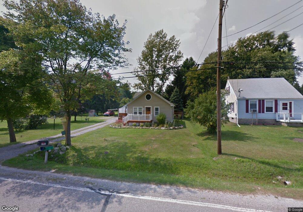
2761 Beach Rd Port Huron, MI 48060
Estimated Value: $198,000 - $296,648
3
Beds
1
Bath
1,204
Sq Ft
$194/Sq Ft
Est. Value
About This Home
This home is located at 2761 Beach Rd, Port Huron, MI 48060 and is currently estimated at $234,162, approximately $194 per square foot. 2761 Beach Rd is a home located in St. Clair County with nearby schools including Michigamme Elementary School, Central Middle School, and Port Huron High School.
Ownership History
Date
Name
Owned For
Owner Type
Purchase Details
Closed on
Mar 14, 2017
Sold by
Churchill Kirk D
Bought by
Churchill Krik D and Churchill Karen J
Current Estimated Value
Purchase Details
Closed on
Nov 28, 2011
Sold by
Spacil Kevin
Bought by
Churchill Kirk D
Purchase Details
Closed on
Jul 10, 2006
Sold by
Citimortgage Inc
Bought by
Spacil Kevin
Home Financials for this Owner
Home Financials are based on the most recent Mortgage that was taken out on this home.
Original Mortgage
$126,000
Interest Rate
6.82%
Mortgage Type
Future Advance Clause Open End Mortgage
Purchase Details
Closed on
Mar 15, 2005
Sold by
Hutchison Keith A
Bought by
Franklin Mortgage Funding Inc
Create a Home Valuation Report for This Property
The Home Valuation Report is an in-depth analysis detailing your home's value as well as a comparison with similar homes in the area
Home Values in the Area
Average Home Value in this Area
Purchase History
| Date | Buyer | Sale Price | Title Company |
|---|---|---|---|
| Churchill Krik D | -- | None Available | |
| Churchill Kirk D | $55,000 | Liberty Title Agency | |
| Spacil Kevin | $114,000 | First American Title Ins | |
| Franklin Mortgage Funding Inc | -- | None Available |
Source: Public Records
Mortgage History
| Date | Status | Borrower | Loan Amount |
|---|---|---|---|
| Previous Owner | Spacil Kevin | $126,000 |
Source: Public Records
Tax History Compared to Growth
Tax History
| Year | Tax Paid | Tax Assessment Tax Assessment Total Assessment is a certain percentage of the fair market value that is determined by local assessors to be the total taxable value of land and additions on the property. | Land | Improvement |
|---|---|---|---|---|
| 2025 | $2,509 | $132,700 | $0 | $0 |
| 2024 | $1,320 | $128,300 | $0 | $0 |
| 2023 | $1,219 | $114,200 | $0 | $0 |
| 2022 | $2,252 | $104,900 | $0 | $0 |
| 2021 | $2,067 | $98,900 | $0 | $0 |
| 2020 | $2,067 | $89,700 | $11,900 | $77,800 |
| 2019 | $2,023 | $70,500 | $0 | $0 |
| 2018 | $1,986 | $70,500 | $0 | $0 |
| 2017 | $1,924 | $71,000 | $0 | $0 |
| 2016 | $994 | $71,000 | $0 | $0 |
| 2015 | -- | $62,000 | $0 | $62,000 |
| 2014 | -- | $46,900 | $0 | $46,900 |
| 2013 | -- | $45,500 | $0 | $0 |
Source: Public Records
Map
Nearby Homes
- 2863 Beach Rd
- 4380 Lapeer Rd
- 0000 W Water St
- 3152 Spruce Dr
- 3115 Spruce Dr
- 2940 Westland Dr
- 4224 Atkins Rd
- 4608 Huntington Dr
- 3345 Beach Rd
- 3230 Range Rd
- 4361 Peck Rd
- 3335 W Water St
- 3408 N Burwick Dr
- 0 Wall Rd Unit 50185999
- 2566 Lewis Dr
- 3409 Ancient Dr
- 0 Lapeer Rd Unit 50137357
- 4460 Cambridge Dr
- 4911 Castlewood Dr
- 3255 Harrington Rd