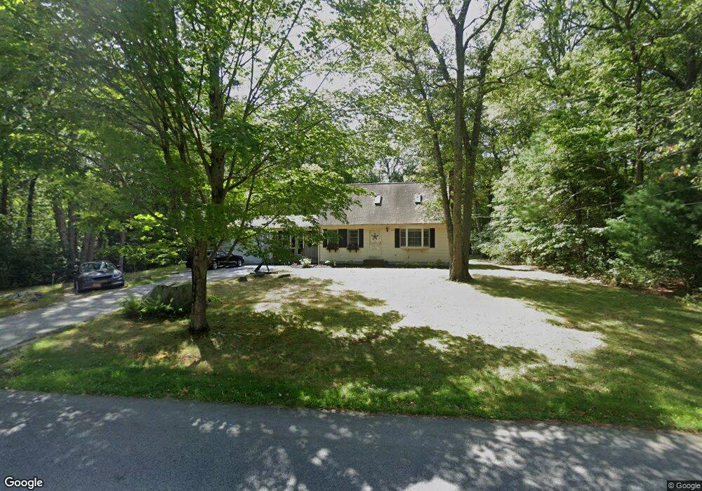
2766 Anderson Dr Dighton, MA 02715
Estimated Value: $556,000 - $716,000
3
Beds
2
Baths
2,336
Sq Ft
$266/Sq Ft
Est. Value
About This Home
This home is located at 2766 Anderson Dr, Dighton, MA 02715 and is currently estimated at $621,565, approximately $266 per square foot. 2766 Anderson Dr is a home located in Bristol County with nearby schools including Dighton-Rehoboth Regional High School, SCEC Life Academy, and Swansea Wood School.
Ownership History
Date
Name
Owned For
Owner Type
Purchase Details
Closed on
Jan 28, 2000
Sold by
Carignan Sue A
Bought by
Rafanan Alan J and Rafanan Melinda T
Current Estimated Value
Home Financials for this Owner
Home Financials are based on the most recent Mortgage that was taken out on this home.
Original Mortgage
$170,900
Outstanding Balance
$55,133
Interest Rate
7.83%
Mortgage Type
Purchase Money Mortgage
Estimated Equity
$566,432
Create a Home Valuation Report for This Property
The Home Valuation Report is an in-depth analysis detailing your home's value as well as a comparison with similar homes in the area
Home Values in the Area
Average Home Value in this Area
Purchase History
| Date | Buyer | Sale Price | Title Company |
|---|---|---|---|
| Rafanan Alan J | $179,000 | -- |
Source: Public Records
Mortgage History
| Date | Status | Borrower | Loan Amount |
|---|---|---|---|
| Open | Rafanan Alan J | $170,900 | |
| Previous Owner | Rafanan Alan J | $74,000 | |
| Previous Owner | Rafanan Alan J | $59,000 |
Source: Public Records
Tax History Compared to Growth
Tax History
| Year | Tax Paid | Tax Assessment Tax Assessment Total Assessment is a certain percentage of the fair market value that is determined by local assessors to be the total taxable value of land and additions on the property. | Land | Improvement |
|---|---|---|---|---|
| 2025 | $5,123 | $407,900 | $133,700 | $274,200 |
| 2024 | $5,103 | $373,000 | $133,700 | $239,300 |
| 2023 | $4,854 | $348,200 | $133,700 | $214,500 |
| 2022 | $4,664 | $326,400 | $130,200 | $196,200 |
| 2021 | $4,412 | $297,500 | $117,600 | $179,900 |
| 2020 | $4,481 | $299,100 | $131,600 | $167,500 |
| 2019 | $4,349 | $290,100 | $131,600 | $158,500 |
| 2018 | $3,996 | $268,700 | $111,500 | $157,200 |
| 2017 | $3,869 | $259,000 | $129,800 | $129,200 |
| 2016 | $3,885 | $255,100 | $133,700 | $121,400 |
| 2015 | $3,818 | $258,000 | $137,600 | $120,400 |
| 2014 | $3,821 | $250,900 | $137,600 | $113,300 |
Source: Public Records
Map
Nearby Homes
- 3075 Club House Dr
- 3064 Clubhouse Dr
- 3055 Clubhouse Dr Unit 80
- 3051 Clubhouse Dr Unit 78
- 3049 Clubhouse Dr Unit 77
- 3035 Clubhouse Dr
- 3035 Clubhouse Dr Unit 8
- 3035 Clubhouse Dr Unit 7
- 3035 Clubhouse Dr Unit 6
- 3035 Clubhouse Dr Unit 5
- 3035 Clubhouse Dr Unit 4
- 3035 Clubhouse Dr Unit 3
- 3035 Clubhouse Dr Unit 2
- 3035 Clubhouse Dr Unit 1
- 32 Clubhouse Dr Unit RR32
- R61 Clubhouse Dr Unit R61
- 3057 Clubhouse Dr
- 48 Laurie Ln
- 172 High Hill Rd
- 2535 Williams St
- 2700 Anderson Dr
- 2877 Anderson Dr
- 2855 Anderson Dr
- 2633 Anderson Dr
- 3339 Sharps Lot Rd
- 2600 Anderson Dr
- 2800 Anderson Dr
- 2933 Anderson Dr
- 2555 Anderson Dr
- 2922 Anderson Dr
- 3189 Sharps Lot Rd
- 2955 Anderson Dr
- 3235 Sharps Lot Rd
- 3255 Sharps Lot Rd
- 3203 Sharps Lot Rd
- 3349 Sharps Lot Rd
- 3239 Sharps Lot Rd
- 3147 Sharps Lot Rd
- 3169 Sharps Lot Rd
- 3277 Sharps Lot Rd