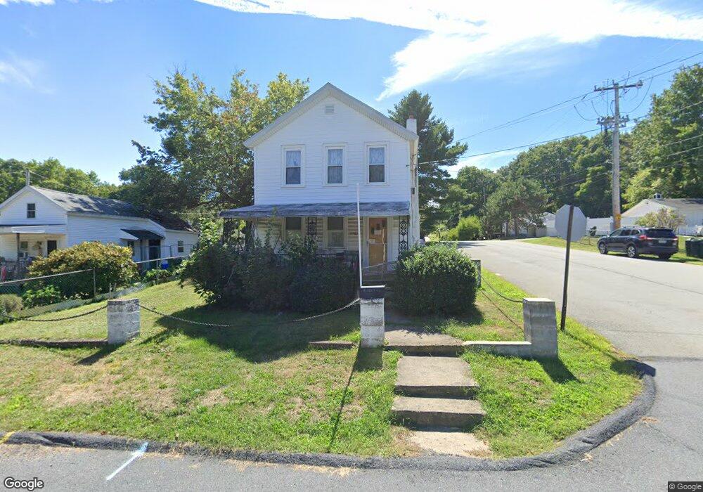
2767 Frink St Scranton, PA 18504
West Mountain NeighborhoodEstimated Value: $139,123 - $276,000
--
Bed
--
Bath
--
Sq Ft
0.38
Acres
About This Home
This home is located at 2767 Frink St, Scranton, PA 18504 and is currently estimated at $192,281. 2767 Frink St is a home located in Lackawanna County with nearby schools including Isaac Tripp Elementary School, West Scranton Intrmd School, and West Scranton High School.
Ownership History
Date
Name
Owned For
Owner Type
Purchase Details
Closed on
Jun 28, 2024
Sold by
Sherman Lana Mae
Bought by
Saita Judy E
Current Estimated Value
Purchase Details
Closed on
Nov 9, 1994
Bought by
Sherman Lana Mae
Create a Home Valuation Report for This Property
The Home Valuation Report is an in-depth analysis detailing your home's value as well as a comparison with similar homes in the area
Home Values in the Area
Average Home Value in this Area
Purchase History
| Date | Buyer | Sale Price | Title Company |
|---|---|---|---|
| Saita Judy E | -- | None Listed On Document | |
| Sherman Lana Mae | -- | -- |
Source: Public Records
Tax History Compared to Growth
Tax History
| Year | Tax Paid | Tax Assessment Tax Assessment Total Assessment is a certain percentage of the fair market value that is determined by local assessors to be the total taxable value of land and additions on the property. | Land | Improvement |
|---|---|---|---|---|
| 2025 | $2,171 | $7,000 | $700 | $6,300 |
| 2024 | $1,978 | $7,000 | $700 | $6,300 |
| 2023 | $1,978 | $7,000 | $700 | $6,300 |
| 2022 | $1,935 | $7,000 | $700 | $6,300 |
| 2021 | $1,935 | $7,000 | $700 | $6,300 |
| 2020 | $1,897 | $7,000 | $700 | $6,300 |
| 2019 | $1,783 | $7,000 | $700 | $6,300 |
| 2018 | $1,783 | $7,000 | $700 | $6,300 |
| 2017 | $1,750 | $7,000 | $700 | $6,300 |
| 2016 | $481 | $7,000 | $700 | $6,300 |
| 2015 | $970 | $7,000 | $700 | $6,300 |
| 2014 | -- | $7,000 | $700 | $6,300 |
Source: Public Records
Map
Nearby Homes
- 2749 Jackson St
- 0 Marginal Rd Unit GSBSC253025
- 0 Crisp Ave and Division St Unit 22-3646
- 2613 Jackson St
- 138 S Keyser Ave
- 0 Roanoke Ln Unit GSBSC254856
- 0 Way
- 107 Ridgeview Dr
- 2503 2505 Swetland St Unit L 2
- 2133 35 Jackson St
- 2127 Price St
- 813 S Keyser Ave
- 121 Ridgeview Dr
- 745 Newton Rd
- 28 Ridgeview Dr
- 1924 Luzerne St
- 133 S Van Buren Ave
- 120 N Van Buren Ave
- 1919 Price St
- 138-140 S Everett Ave
- 2763 Frink St
- 2763 Frink St
- 2801 Frink St
- 2757 Frink St
- 2711/2717 Frink St
- 2749 Frink St
- 207 Crisp Ave
- 2762 Frink St
- 204 Crisp Ave
- 2763 Jackson St
- 108 Crisp Ave Unit 10
- 317 319 16th St
- 2761 Jackson St
- 2813 Frink St
- 2750 Frink St
- 2747 Frink St
- 2759 Jackson St
- 2814 Frink St
- 2815 Frink St Unit R
- 2815 Frink St