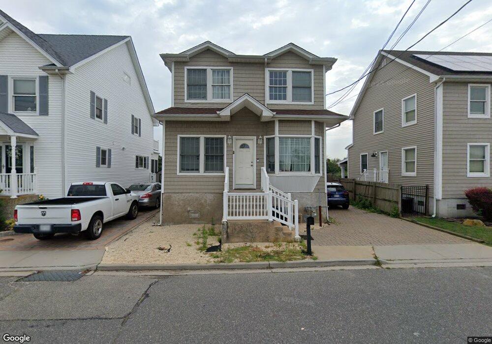
2769 Ocean Ave Seaford, NY 11783
Estimated Value: $825,670 - $876,000
4
Beds
3
Baths
2,285
Sq Ft
$372/Sq Ft
Est. Value
About This Home
This home is located at 2769 Ocean Ave, Seaford, NY 11783 and is currently estimated at $850,835, approximately $372 per square foot. 2769 Ocean Ave is a home located in Nassau County with nearby schools including Seaford Middle School, Seaford Senior High School, and Maplewood School.
Ownership History
Date
Name
Owned For
Owner Type
Purchase Details
Closed on
Jun 10, 2025
Sold by
Sunnys Kids Llc
Bought by
Shooshtary Mathew and Langan Ciara
Current Estimated Value
Home Financials for this Owner
Home Financials are based on the most recent Mortgage that was taken out on this home.
Original Mortgage
$666,971
Outstanding Balance
$665,242
Interest Rate
6.76%
Mortgage Type
FHA
Estimated Equity
$185,593
Purchase Details
Closed on
Jun 10, 2005
Sold by
Welt Carey
Bought by
Sunnys Kids Llc
Create a Home Valuation Report for This Property
The Home Valuation Report is an in-depth analysis detailing your home's value as well as a comparison with similar homes in the area
Home Values in the Area
Average Home Value in this Area
Purchase History
| Date | Buyer | Sale Price | Title Company |
|---|---|---|---|
| Shooshtary Mathew | $690,000 | None Available | |
| Sunnys Kids Llc | $292,500 | -- | |
| Sunnys Kids Llc | $292,500 | -- |
Source: Public Records
Mortgage History
| Date | Status | Borrower | Loan Amount |
|---|---|---|---|
| Open | Shooshtary Mathew | $666,971 |
Source: Public Records
Tax History Compared to Growth
Tax History
| Year | Tax Paid | Tax Assessment Tax Assessment Total Assessment is a certain percentage of the fair market value that is determined by local assessors to be the total taxable value of land and additions on the property. | Land | Improvement |
|---|---|---|---|---|
| 2025 | $15,232 | $518 | $138 | $380 |
| 2024 | $3,486 | $518 | $138 | $380 |
| 2023 | $12,266 | $518 | $138 | $380 |
| 2022 | $12,266 | $518 | $138 | $380 |
| 2021 | $10,886 | $595 | $149 | $446 |
| 2020 | $6,290 | $661 | $660 | $1 |
| 2019 | $11,954 | $708 | $707 | $1 |
| 2018 | $12,154 | $756 | $0 | $0 |
| 2017 | $8,951 | $803 | $708 | $95 |
| 2016 | $12,457 | $1,006 | $887 | $119 |
| 2015 | $4,099 | $1,006 | $721 | $285 |
| 2014 | $4,099 | $1,006 | $721 | $285 |
| 2013 | $3,845 | $1,006 | $721 | $285 |
Source: Public Records
Map
Nearby Homes
- 3570 Plover Place
- 3609 Somerset Dr
- 3695 Somerset Dr
- 2655 Ocean Ave
- 3717 Somerset Dr
- 3668 Naomi St
- 2601 Ocean Ave
- 3651 Marinor St
- 2905 Ocean Ave
- 3692 Ocean Ave
- 2573 Harvard Ln
- 2701 S Seamans Neck Rd
- 7 Crescent Cove Dr
- 220 Shore Rd
- 0 Island Place Unit 3107575
- 3663 Roanoke St
- 3563 Wadena St
- 2419 Cedar St
- 3612 Ladonia St
- 3608 Tonopah St
- 2765 Ocean Ave
- 2775 Ocean Ave
- 2759 Ocean Ave
- 2854 Peconic Ave
- 2751 Ocean Ave
- 2740 Ocean Ave
- 2739 Ocean Ave
- 2750 Bay Place
- 3589 Somerset Dr
- 2738 Bay Place
- 2740 Peconic Ave
- 2800 Ocean Ave
- 3595 Somerset Dr
- 2730 Ocean Ave
- 2733 Ocean Ave
- 3601 Somerset Dr
- 3601 Somerset Dr
- 2775 Island Channel Rd
- 3573 Anglers Place
- 3573 Anglers Place