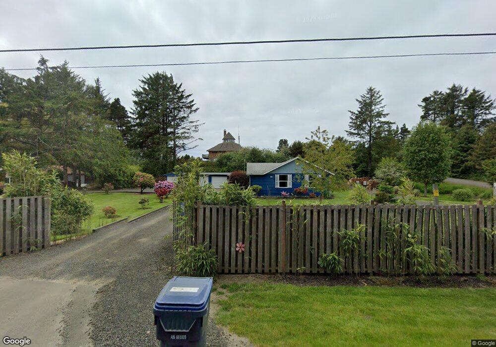
2771 S Forrest St Westport, WA 98595
Cohassett Beach NeighborhoodEstimated Value: $289,000 - $378,000
2
Beds
1
Bath
1,271
Sq Ft
$273/Sq Ft
Est. Value
About This Home
This home is located at 2771 S Forrest St, Westport, WA 98595 and is currently estimated at $347,389, approximately $273 per square foot. 2771 S Forrest St is a home located in Grays Harbor County with nearby schools including Ocosta Elementary School and Ocosta Junior/Senior High School.
Ownership History
Date
Name
Owned For
Owner Type
Purchase Details
Closed on
Aug 5, 2025
Sold by
Johnson Reina Christine and Johnson Gerald S
Bought by
Johnson Gerald S
Current Estimated Value
Purchase Details
Closed on
Aug 5, 2011
Sold by
Anchor Bank
Bought by
Johnson Gerald S and Johnson Reina C
Purchase Details
Closed on
Apr 26, 2011
Sold by
Nelson Peter A and Nelson Joanne L
Bought by
Anchor Bank
Purchase Details
Closed on
Sep 7, 2006
Sold by
Nelson Joanne L
Bought by
Nelson Peter A
Create a Home Valuation Report for This Property
The Home Valuation Report is an in-depth analysis detailing your home's value as well as a comparison with similar homes in the area
Home Values in the Area
Average Home Value in this Area
Purchase History
| Date | Buyer | Sale Price | Title Company |
|---|---|---|---|
| Johnson Gerald S | -- | None Listed On Document | |
| Johnson Gerald S | $30,000 | Coast Title | |
| Anchor Bank | $34,135 | None Available | |
| Nelson Peter A | -- | None Available |
Source: Public Records
Tax History Compared to Growth
Tax History
| Year | Tax Paid | Tax Assessment Tax Assessment Total Assessment is a certain percentage of the fair market value that is determined by local assessors to be the total taxable value of land and additions on the property. | Land | Improvement |
|---|---|---|---|---|
| 2025 | $2,704 | $293,884 | $130,572 | $163,312 |
| 2023 | $2,521 | $260,032 | $96,720 | $163,312 |
| 2022 | $2,185 | $176,664 | $62,400 | $114,264 |
| 2021 | $2,063 | $176,664 | $62,400 | $114,264 |
| 2020 | $1,587 | $151,957 | $52,000 | $99,957 |
| 2019 | $1,552 | $111,858 | $28,050 | $83,808 |
| 2018 | $1,474 | $111,858 | $28,050 | $83,808 |
| 2017 | $1,436 | $95,340 | $25,500 | $69,840 |
| 2016 | $1,304 | $95,340 | $25,500 | $69,840 |
| 2014 | -- | $94,070 | $25,500 | $68,570 |
| 2013 | -- | $121,775 | $30,000 | $91,775 |
Source: Public Records
Map
Nearby Homes
- 5 Sea Mist Ln
- 605 Claymore Ln
- 0 State Route 105 S
- 33 Linder Ln
- 167 E Woodhill Ave
- 1816 S Melbourne St
- 1816 S Melbourne St Unit 9
- 2081 Grey Gull Ln S
- 1817 Hoquiam Ln S
- 114 Bayview Ln
- 1620 S Ocosta St
- 1610 S Ocosta St
- 1505 Beach Glass Ln
- 1501 Beach Glass Ln
- 1302 S Melbourne St
- 1500 Agate Ln
- 1213 Johnson St
- 1401 Cohasset Crest S
- 1505 Wild Rose Ln
- 1310 S Montesano St
- 2829 S Forrest St
- 2801 S Forrest St
- 2855 S Forrest St Unit 205
- 2855 S Forrest St Unit 104
- 2855 S Forrest St Unit 103
- 2855 S Forrest St Unit 105
- 2855 S Forrest St Unit 201
- 2855 S Forrest St Unit 202
- 2855 S Forrest St Unit 106
- 2855 S Forrest St Unit 101
- 2855 S Forrest St Unit 102
- 2855 S Forrest St Unit 207
- 2855 S Forrest St Unit 203
- 2855 S Forrest St Unit 206
- 13 Sea Mist Ln
- 21 Sea Mist Ln
- 2907 S Forrest St
- 2931 S Forrest St
- 2858 S Forrest St
- 604 W Claymore Ln