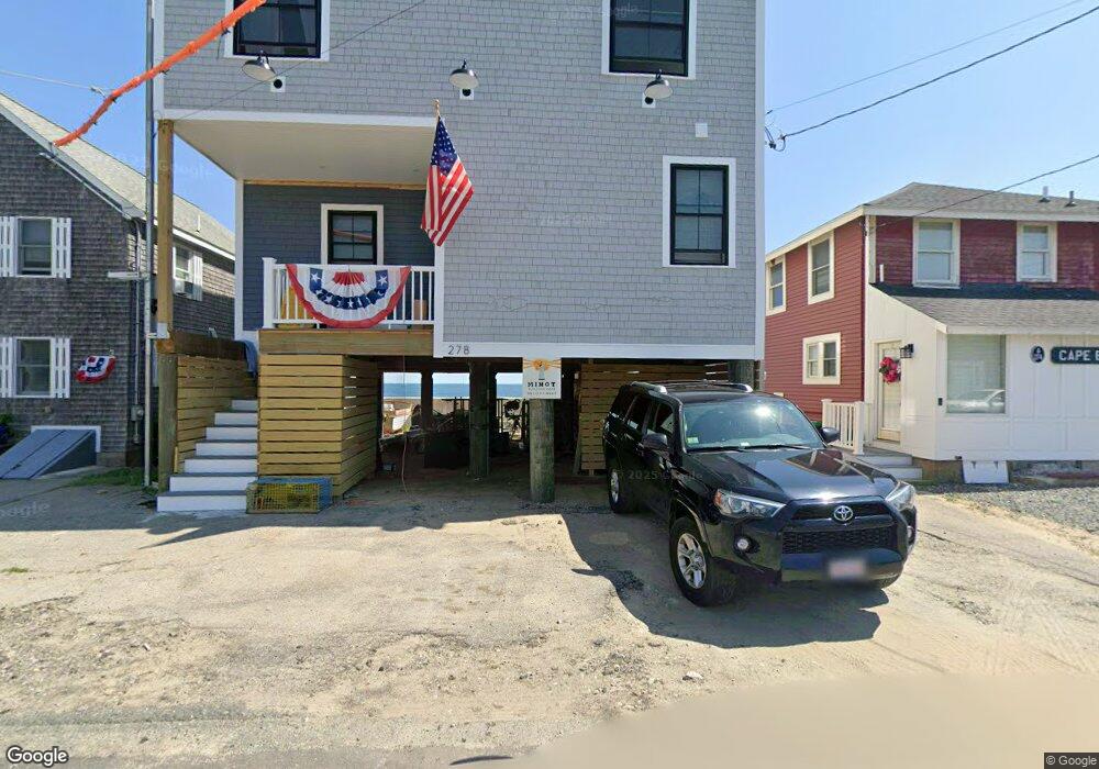
278 Foster Ave Marshfield, MA 02050
Ocean Bluff-Brant Rock NeighborhoodEstimated Value: $919,000 - $1,040,000
3
Beds
2
Baths
1,638
Sq Ft
$597/Sq Ft
Est. Value
About This Home
This home is located at 278 Foster Ave, Marshfield, MA 02050 and is currently estimated at $978,394, approximately $597 per square foot. 278 Foster Ave is a home located in Plymouth County with nearby schools including Daniel Webster, Furnace Brook Middle School, and Marshfield High School.
Ownership History
Date
Name
Owned For
Owner Type
Purchase Details
Closed on
Jun 14, 2024
Sold by
Birl Toni-Jo
Bought by
Hammell Jennifer A
Current Estimated Value
Purchase Details
Closed on
Aug 10, 2019
Sold by
Pesco Ft and Birk
Bought by
Birk Toni-Jo
Purchase Details
Closed on
Nov 18, 2011
Sold by
Pescosolido Charlotte
Bought by
Pesco Ft and Birk
Create a Home Valuation Report for This Property
The Home Valuation Report is an in-depth analysis detailing your home's value as well as a comparison with similar homes in the area
Home Values in the Area
Average Home Value in this Area
Purchase History
| Date | Buyer | Sale Price | Title Company |
|---|---|---|---|
| Hammell Jennifer A | $825,500 | None Available | |
| Hammell Jennifer A | $825,500 | None Available | |
| Hammell Jennifer A | $825,500 | None Available | |
| Birk Toni-Jo | $250,000 | -- | |
| Birk Toni-Jo | $250,000 | -- | |
| Pesco Ft | -- | -- | |
| Pescosolido Charlotte | -- | -- | |
| Pesco Ft | -- | -- | |
| Pescosolido Charlotte | -- | -- | |
| Pescosolido Charlotte | -- | -- |
Source: Public Records
Tax History Compared to Growth
Tax History
| Year | Tax Paid | Tax Assessment Tax Assessment Total Assessment is a certain percentage of the fair market value that is determined by local assessors to be the total taxable value of land and additions on the property. | Land | Improvement |
|---|---|---|---|---|
| 2025 | $10,907 | $1,101,700 | $831,900 | $269,800 |
| 2024 | $10,376 | $998,700 | $752,700 | $246,000 |
| 2023 | $9,443 | $927,500 | $713,100 | $214,400 |
| 2022 | $9,443 | $729,200 | $544,700 | $184,500 |
| 2021 | $8,351 | $633,100 | $465,500 | $167,600 |
| 2020 | $7,986 | $599,100 | $435,800 | $163,300 |
| 2019 | $7,902 | $590,600 | $435,800 | $154,800 |
| 2018 | $7,859 | $587,800 | $435,800 | $152,000 |
| 2017 | $7,905 | $576,200 | $435,800 | $140,400 |
| 2016 | $7,880 | $567,700 | $435,800 | $131,900 |
| 2015 | $8,573 | $645,100 | $515,000 | $130,100 |
| 2014 | $7,962 | $599,100 | $475,400 | $123,700 |
Source: Public Records
Map
Nearby Homes