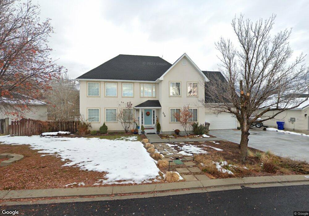
278 Hillside Cir Alpine, UT 84004
Estimated Value: $823,000 - $1,217,000
4
Beds
4
Baths
3,978
Sq Ft
$241/Sq Ft
Est. Value
About This Home
This home is located at 278 Hillside Cir, Alpine, UT 84004 and is currently estimated at $957,501, approximately $240 per square foot. 278 Hillside Cir is a home located in Utah County with nearby schools including Westfield School, Timberline Middle School, and Lone Peak High School.
Ownership History
Date
Name
Owned For
Owner Type
Purchase Details
Closed on
Jun 14, 2012
Sold by
The Bank Of New York Mellon
Bought by
Morno Martin
Current Estimated Value
Home Financials for this Owner
Home Financials are based on the most recent Mortgage that was taken out on this home.
Original Mortgage
$259,960
Outstanding Balance
$178,377
Interest Rate
3.62%
Mortgage Type
New Conventional
Estimated Equity
$779,124
Purchase Details
Closed on
Sep 21, 2011
Sold by
Xanthos Elefterios A
Bought by
The Bank Of New York Mellon
Purchase Details
Closed on
Jul 7, 2006
Sold by
Rowley Daron H and Rowley Kimberly G
Bought by
Xanthos Elefterios A
Home Financials for this Owner
Home Financials are based on the most recent Mortgage that was taken out on this home.
Original Mortgage
$357,600
Interest Rate
6.57%
Mortgage Type
Purchase Money Mortgage
Purchase Details
Closed on
Jul 11, 2003
Sold by
The Knox Family Lp
Bought by
Rowley Daron H and Rowley Kimberly G
Home Financials for this Owner
Home Financials are based on the most recent Mortgage that was taken out on this home.
Original Mortgage
$115,733
Interest Rate
5.18%
Mortgage Type
Credit Line Revolving
Purchase Details
Closed on
Aug 7, 2002
Sold by
Rowley Daron Hart and Rowley Kimberly
Bought by
The Knox Family Ltd Partnership
Home Financials for this Owner
Home Financials are based on the most recent Mortgage that was taken out on this home.
Original Mortgage
$137,000
Interest Rate
6.52%
Purchase Details
Closed on
Feb 1, 2002
Sold by
Rowley Daron H and Rowley Kimberly G
Bought by
Knox Family Ltd Partnership
Purchase Details
Closed on
Jun 26, 1996
Sold by
Rowley Daron H and Rowley Kimberly G
Bought by
Rowley Daron H and Rowley Kimberly G
Home Financials for this Owner
Home Financials are based on the most recent Mortgage that was taken out on this home.
Original Mortgage
$48,000
Interest Rate
8.09%
Create a Home Valuation Report for This Property
The Home Valuation Report is an in-depth analysis detailing your home's value as well as a comparison with similar homes in the area
Home Values in the Area
Average Home Value in this Area
Purchase History
| Date | Buyer | Sale Price | Title Company |
|---|---|---|---|
| Morno Martin | -- | Metro National Title | |
| The Bank Of New York Mellon | -- | Guardian Title Company Of Ut | |
| Xanthos Elefterios A | -- | Old Republic Title Company | |
| Rowley Daron H | -- | Mountain West Title Co | |
| The Knox Family Ltd Partnership | -- | Equity Title Agency Inc | |
| Rowley Daron Hart | -- | Equity Title Agency Inc | |
| Knox Family Ltd Partnership | -- | -- | |
| Rowley Daron H | -- | First American Title |
Source: Public Records
Mortgage History
| Date | Status | Borrower | Loan Amount |
|---|---|---|---|
| Open | Morno Martin | $259,960 | |
| Previous Owner | Xanthos Elefterios A | $357,600 | |
| Previous Owner | Rowley Daron H | $115,733 | |
| Previous Owner | Rowley Daron Hart | $137,000 | |
| Previous Owner | Rowley Daron H | $48,000 |
Source: Public Records
Tax History
| Year | Tax Paid | Tax Assessment Tax Assessment Total Assessment is a certain percentage of the fair market value that is determined by local assessors to be the total taxable value of land and additions on the property. | Land | Improvement |
|---|---|---|---|---|
| 2025 | $3,313 | $391,765 | -- | -- |
| 2024 | $3,313 | $386,100 | $0 | $0 |
| 2023 | $3,236 | $404,855 | $0 | $0 |
| 2022 | $3,090 | $375,540 | $0 | $0 |
| 2021 | $2,723 | $514,000 | $187,300 | $326,700 |
| 2020 | $2,566 | $474,000 | $162,900 | $311,100 |
| 2019 | $2,247 | $433,400 | $162,900 | $270,500 |
| 2018 | $2,123 | $404,500 | $149,900 | $254,600 |
| 2017 | $2,026 | $205,480 | $0 | $0 |
| 2016 | $2,142 | $202,455 | $0 | $0 |
| 2015 | $1,986 | $177,650 | $0 | $0 |
| 2014 | $1,665 | $147,290 | $0 | $0 |
Source: Public Records
Map
Nearby Homes
- 353 International Way
- 820 Eagleview Dr
- 684 N Summit Way
- 151 Glacier Lily Dr
- 501 W Devey Dr
- 248 Deerfield Dr
- 19 E Elk Ct
- 475 Grove Dr
- 128 E Deer Crest Ln Unit 304
- 522 N Pfeifferhorn Dr
- 48 N 100 E
- 30 S Main St
- 512 Eastridge Cir
- 591 N Pfeifferhorn Dr
- 287 Heritage Hills Dr
- 102 E Deer Crest Ln
- 381 E Watkins Cir Unit 28
- 382 E Heritage Hills Dr
- 12513 Timberline Dr
- 499 E 300 N
- 276 Hillside Cir
- 262 Hillside Cir
- 292 Hillside Cir
- 283 Hillside Cir
- 269 Hillside Cir
- 246 Hillside Cir
- 308 Hillside Cir
- 297 Hillside Cir
- 251 Hillside Cir
- 315 Hillside Cir
- 232 Hillside Cir
- 326 Hillside Cir
- 649 Hillside Cir
- 233 Hillside Cir
- 327 International Way
- 631 Hillside Cir
- 631 N Hillside Dr
- 311 International Way
- 311 International Way Unit 16
- 336 Hillside Cir
Your Personal Tour Guide
Ask me questions while you tour the home.