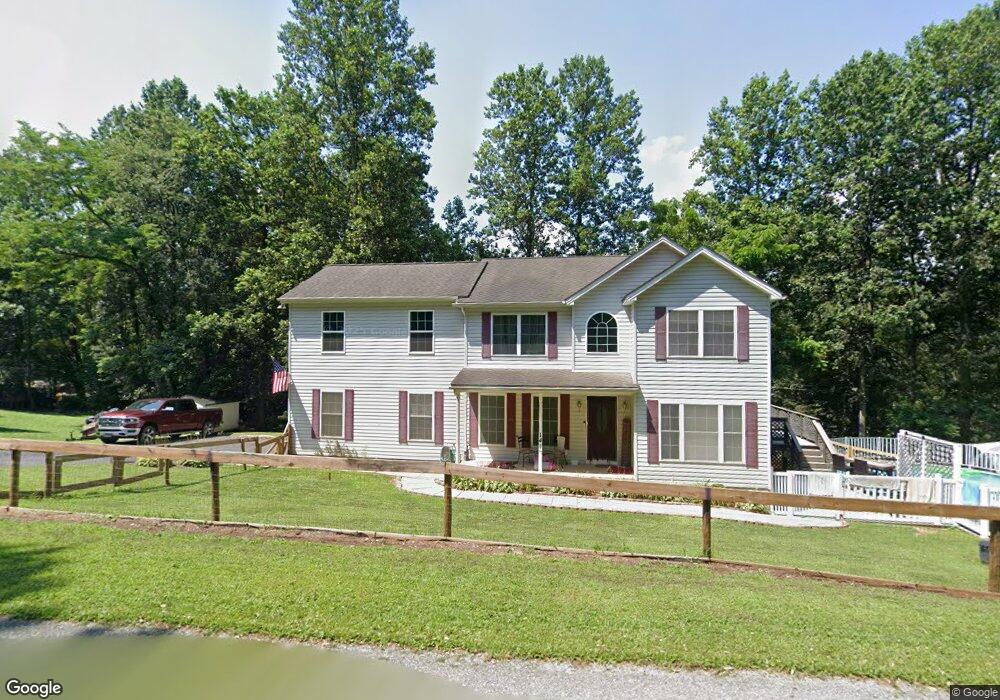
278 Neill Run Rd Delta, PA 17314
Susquehanna Trails NeighborhoodEstimated Value: $252,000 - $356,000
3
Beds
3
Baths
1,120
Sq Ft
$270/Sq Ft
Est. Value
About This Home
This home is located at 278 Neill Run Rd, Delta, PA 17314 and is currently estimated at $302,219, approximately $269 per square foot. 278 Neill Run Rd is a home located in York County with nearby schools including South Eastern Intermediate School, South Eastern Middle School, and Kennard-Dale High School.
Ownership History
Date
Name
Owned For
Owner Type
Purchase Details
Closed on
Aug 17, 2005
Sold by
Ammons Richard E
Bought by
Wedekind Dennis L and Wedekind Amy D
Current Estimated Value
Home Financials for this Owner
Home Financials are based on the most recent Mortgage that was taken out on this home.
Original Mortgage
$234,900
Outstanding Balance
$123,396
Interest Rate
5.66%
Mortgage Type
Fannie Mae Freddie Mac
Estimated Equity
$178,823
Purchase Details
Closed on
Mar 10, 2004
Sold by
Tax Claim Bureau Of York County
Bought by
Ammons Richard E
Create a Home Valuation Report for This Property
The Home Valuation Report is an in-depth analysis detailing your home's value as well as a comparison with similar homes in the area
Home Values in the Area
Average Home Value in this Area
Purchase History
| Date | Buyer | Sale Price | Title Company |
|---|---|---|---|
| Wedekind Dennis L | $234,900 | -- | |
| Ammons Richard E | $500 | -- |
Source: Public Records
Mortgage History
| Date | Status | Borrower | Loan Amount |
|---|---|---|---|
| Open | Wedekind Dennis L | $234,900 |
Source: Public Records
Tax History Compared to Growth
Tax History
| Year | Tax Paid | Tax Assessment Tax Assessment Total Assessment is a certain percentage of the fair market value that is determined by local assessors to be the total taxable value of land and additions on the property. | Land | Improvement |
|---|---|---|---|---|
| 2025 | $3,624 | $120,330 | $32,360 | $87,970 |
| 2024 | $3,624 | $120,330 | $32,360 | $87,970 |
| 2023 | $3,624 | $120,330 | $32,360 | $87,970 |
| 2022 | $3,624 | $120,330 | $32,360 | $87,970 |
| 2021 | $3,504 | $120,330 | $32,360 | $87,970 |
| 2020 | $3,444 | $120,330 | $32,360 | $87,970 |
| 2019 | $3,432 | $120,330 | $32,360 | $87,970 |
| 2018 | $3,432 | $120,330 | $32,360 | $87,970 |
| 2017 | $3,432 | $120,330 | $32,360 | $87,970 |
| 2016 | $0 | $120,330 | $32,360 | $87,970 |
| 2015 | -- | $120,330 | $32,360 | $87,970 |
| 2014 | -- | $120,330 | $32,360 | $87,970 |
Source: Public Records
Map
Nearby Homes
- 113 Corn Tassel Rd
- 46 Corn Tassel Rd
- 64 N White Pine Trail
- 45 Wenzel Rd
- 375 Meadow Trail
- 63 Cherry Rd
- 0 Highview Dr
- 0 Dogwood Rd
- 556 Bair Rd
- 64 Hemlock Hill Rd
- 8290 Woodbine Rd
- 219 A Highfield Rd
- 115 Highfield Rd
- Lot C Bryansville Rd
- 16 High Ridge Rd
- 267 Cook Rd
- 61 63 65 W Mckinley Rd
- 54 Mitchell Rd
- Lot 4 Ridge Rd
- 65 W Mckinley Rd
- 141 Corn Tassel Rd
- 129 Corn Tassel Rd
- 250 Neill Run Rd
- 1 Oak Dr
- 14 Oak Dr
- 308 Neill Run Rd
- 302 Gemmill Rd
- 21 Oak Forest Rd
- 316 Gemmill Rd
- 12 Oak Forest Rd
- 21 Oak Dr
- 199 Neill Run Rd
- 211 Neill Run Rd
- 213 Gemmill Rd
- 22 Oak Forest Rd
- 93 Corn Tassel Rd
- 32 Oak Dr
- 37 Oak Dr
- 191 Neill Run Rd
- 226 Neill Run Rd