
Seller's Agent in 2025
Mary Skwiera
Berkshire Hathaway HomeServices Kee Realty Browns
(734) 558-1645
3 in this area
71 Total Sales
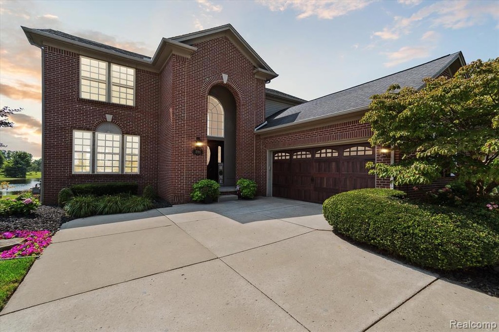
**ORIGINAL OWNERS OF A BEAUTIFUL, WELL-MAINTAINED, 4 BEDROOM, 2 FULL BATH, 2 HALF BATH COLONIAL IN A SOUGHT AFTER HURON TWP SUBDIVISION**THIS HOME SITS ON A DESIRABLE PREMIUM LOT THAT BACKS UP TO THE POND AND ACROSS FROM THE NEIGHBORHOOD PARK**THE FRONT AND BACKYARD ARE PROFESSIONALLY LANDSCAPED OFFERING EXQUISITE CURB APPEAL**COVERED FRONT PORCH WITH CUSTOM FRONT DOOR**THEN STEP INTO THE 2 STORY FOYER WITH WAINSCOTING AND HARDWOOD FLOORS, LIVING ROOM WITH CUSTOM FEATURE WALL, FRENCH DOORS, NEW CARPET THAT LEADS INTO A SPACIOUS DINING ROOM WITH LARGE BAY WINDOW OFFERING EXPANSIVE VIEWS OF THE POND**KITCHEN WITH SS CABINETS, QUARTZ COUNTER TOPS, CUSTOM BACKSPLASH, HARDWOOD FLOORS, STAINLESS APPLIANCES AND NOOK WITH DOOR WALL**KITCHEN IS OPEN TO LARGE FAMILY ROOM WITH GAS FIREPLACE WITH STACK STONE, FRESHLY PAINTED AND NEW CARPET**POWDER ROOM WITH CERAMIC FLOORING**FRENCH DOOR LEADING TO A FINISHED BASEMENT WITH WET BAR, HALF BATH, SUMP PUMP WITH BATTERY BACKUP, FOUR LARGE GARDEN WINDOWS LETTING IN A TON OF NATURAL LIGHT, THIS IS A PERFECT SPACE FOR ENTERTAINING AND MOVIE NIGHT**UPSTAIRS OFFERS FOUR LARGE BEDROOMS WITH NEWER CARPET**PRIMARY BEDROOM WITH VAULTED CEILING , LARGE WINDOWS ALONG THE BACK WALL WITH VIEWS OF THE POND AND LARGE PRIMARY BATHROOM WITH GRANITE COUNTER TOPS, DOUBLE SINKS, VANITY AREA, CERAMIC SHOWER WITH GLASS ENCLOSURE, SOAKING TUB, LARGE WIC AND CERAMIC FLOORING**UPDATED FULL BATH WITH DOUBLE SINKS, QUARTZ COUNTER TOPS AND SECOND FLOOR LAUNDRY**STEP OUT ONTO YOUR DECK WITH LUSH LANDSCAPING OFFERING PRIVACY THAT MAKES IT PERFECT FOR ENTERTAINING**3.5 CAR COURTYARD GARAGE WITH 2 PARKING SPACES, LOTS OF ROOM FOR STORAGE, DRYWALLED AND INSULATED DOOR**SELLER TO PROVIDE C OF O AT CLOSING**EXCLUSIONS, SEE ADDENDUM**BATVAI**SELLER IS AGENT**HOME IS UNDER SURVEILLANCE AND AUDIO**
Last Agent to Sell the Property
Berkshire Hathaway HomeServices Kee Realty Browns License #6501379482 Listed on: 08/08/2025
| Date | Type | Sale Price | Title Company |
|---|---|---|---|
| Warranty Deed | $78,000 | Metropolitan Title Company |
| Date | Event | Price | List to Sale | Price per Sq Ft |
|---|---|---|---|---|
| 09/22/2025 09/22/25 | Sold | $440,000 | 0.0% | $176 / Sq Ft |
| 08/14/2025 08/14/25 | Pending | -- | -- | -- |
| 08/08/2025 08/08/25 | For Sale | $439,900 | -- | $176 / Sq Ft |
| Year | Tax Paid | Tax Assessment Tax Assessment Total Assessment is a certain percentage of the fair market value that is determined by local assessors to be the total taxable value of land and additions on the property. | Land | Improvement |
|---|---|---|---|---|
| 2025 | $2,607 | $193,700 | $0 | $0 |
| 2024 | $2,607 | $181,000 | $0 | $0 |
| 2023 | $2,486 | $156,600 | $0 | $0 |
| 2022 | $4,337 | $160,300 | $0 | $0 |
| 2021 | $4,203 | $147,200 | $0 | $0 |
| 2020 | $4,150 | $142,400 | $0 | $0 |
| 2019 | $3,962 | $137,400 | $0 | $0 |
| 2018 | $2,172 | $133,500 | $0 | $0 |
| 2017 | $3,315 | $124,600 | $0 | $0 |
| 2016 | $3,772 | $124,600 | $0 | $0 |
| 2015 | $9,414 | $113,300 | $0 | $0 |
| 2013 | $9,120 | $91,200 | $0 | $0 |
| 2012 | -- | $89,400 | $21,800 | $67,600 |
Seller's Agent in 2025
Mary Skwiera
Berkshire Hathaway HomeServices Kee Realty Browns
(734) 558-1645
3 in this area
71 Total Sales
K
Buyer's Agent in 2025
Katie Delgiudice
Help U Sell Metro Detroit
(734) 362-1111
2 in this area
33 Total Sales
Source: Realcomp
MLS Number: 20251025285
APN: 75-139-01-0091-000
Disclaimer: Certain information contained herein is derived from information provided by parties other than Homes.com. All information provided is deemed reliable, but is not guaranteed to be accurate and should be independently verified.
![]() IDX provided courtesy of Realcomp II Ltd. via Ten-X and MLS
IDX provided courtesy of Realcomp II Ltd. via Ten-X and MLS
Copyright 2025 Realcomp II Ltd. Shareholders
IDX information is provided exclusively for consumers' personal, noncommercial use and may not be used for any purpose other than to identify prospective properties consumers may be interested in purchasing. The accuracy of all information, regardless of source, is not guaranteed or warranted. All information should be independently verified.
Listing Information presented by local MLS brokerage: Ten-X, local REALTOR®- Arlene Richardson - (888)-952-6393