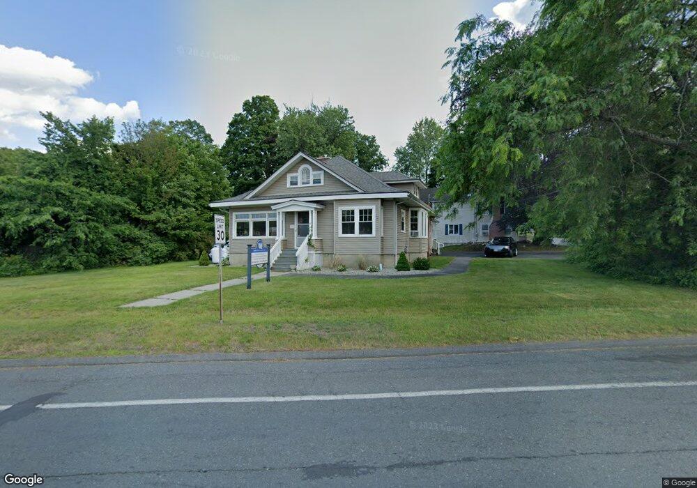
2789 Boston Rd Wilbraham, MA 01095
Estimated Value: $338,867
1
Bed
3
Baths
1,772
Sq Ft
$191/Sq Ft
Est. Value
About This Home
This home is located at 2789 Boston Rd, Wilbraham, MA 01095 and is currently estimated at $338,867, approximately $191 per square foot. 2789 Boston Rd is a home located in Hampden County with nearby schools including Minnechaug Regional High School, St. John the Baptist School, and Wilbraham & Monson Academy.
Ownership History
Date
Name
Owned For
Owner Type
Purchase Details
Closed on
May 16, 2005
Sold by
Dorey Robert L
Bought by
Empire Rt
Current Estimated Value
Home Financials for this Owner
Home Financials are based on the most recent Mortgage that was taken out on this home.
Original Mortgage
$144,000
Outstanding Balance
$76,093
Interest Rate
6.05%
Mortgage Type
Commercial
Estimated Equity
$262,774
Create a Home Valuation Report for This Property
The Home Valuation Report is an in-depth analysis detailing your home's value as well as a comparison with similar homes in the area
Home Values in the Area
Average Home Value in this Area
Purchase History
| Date | Buyer | Sale Price | Title Company |
|---|---|---|---|
| Empire Rt | $180,000 | -- |
Source: Public Records
Mortgage History
| Date | Status | Borrower | Loan Amount |
|---|---|---|---|
| Open | Empire Rt | $144,000 |
Source: Public Records
Tax History Compared to Growth
Tax History
| Year | Tax Paid | Tax Assessment Tax Assessment Total Assessment is a certain percentage of the fair market value that is determined by local assessors to be the total taxable value of land and additions on the property. | Land | Improvement |
|---|---|---|---|---|
| 2025 | $3,698 | $206,800 | $92,300 | $114,500 |
| 2024 | $3,824 | $206,700 | $92,300 | $114,400 |
| 2023 | $43 | $206,900 | $92,300 | $114,600 |
| 2022 | $4,305 | $210,100 | $92,300 | $117,800 |
| 2021 | $4,277 | $186,300 | $97,300 | $89,000 |
| 2020 | $4,169 | $186,300 | $97,300 | $89,000 |
| 2019 | $4,061 | $186,300 | $97,300 | $89,000 |
| 2018 | $4,220 | $186,400 | $97,300 | $89,100 |
| 2017 | $4,101 | $186,400 | $97,300 | $89,100 |
| 2016 | $3,985 | $184,500 | $108,100 | $76,400 |
| 2015 | $3,852 | $184,500 | $108,100 | $76,400 |
Source: Public Records
Map
Nearby Homes
- 2 Vista Rd
- 182 Mountain Rd
- 88-90 Miller St
- 35 Lake Dr
- 54 High Pine Cir
- 4 Hillcrest Dr
- 69 High Pine Cir
- 38 King Dr
- 319 Ventura St
- 22 Balsam Hill Rd
- 46 Washington Rd
- 225 Maynard Rd
- 229 Miller St Unit F-13
- 229 Miller St Unit C-1
- 229 Miller St Unit B2
- 474-480 Mountain Rd
- 20 Old Orchard Rd
- 1172 East St
- 28 Decorie Dr
- 308 Miller St Unit 72