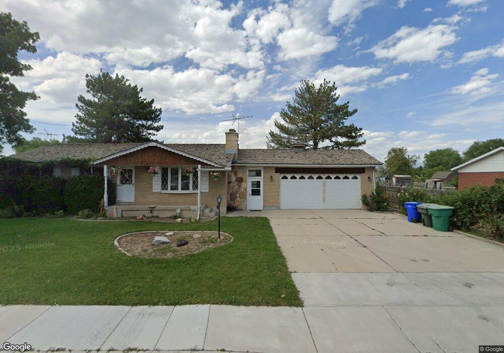
2794 W 7000 S West Jordan, UT 84084
Estimated Value: $557,000 - $609,093
4
Beds
2
Baths
1,218
Sq Ft
$474/Sq Ft
Est. Value
About This Home
This home is located at 2794 W 7000 S, West Jordan, UT 84084 and is currently estimated at $577,523, approximately $474 per square foot. 2794 W 7000 S is a home located in Salt Lake County with nearby schools including West Jordan Middle School, West Jordan High School, and Learning Tree School - Southwest.
Ownership History
Date
Name
Owned For
Owner Type
Purchase Details
Closed on
Sep 29, 2021
Sold by
Blanchfield Lorraine G and Blanchfield Family Trust
Bought by
Blanchfield Family Trust and Blanchfield
Current Estimated Value
Purchase Details
Closed on
Sep 22, 2021
Sold by
Blanchfield Lorraine G and The Blanchfield Family Trust
Bought by
Blanchfield Bradley L and Graham Brenda L
Purchase Details
Closed on
May 8, 2002
Sold by
Blanchfield Bert L and Blanchfield Lorraine G
Bought by
The City Of West Jordan
Create a Home Valuation Report for This Property
The Home Valuation Report is an in-depth analysis detailing your home's value as well as a comparison with similar homes in the area
Home Values in the Area
Average Home Value in this Area
Purchase History
| Date | Buyer | Sale Price | Title Company |
|---|---|---|---|
| Blanchfield Family Trust | -- | -- | |
| Blanchfield Bradley L | -- | Accommodation | |
| The City Of West Jordan | -- | -- |
Source: Public Records
Tax History Compared to Growth
Tax History
| Year | Tax Paid | Tax Assessment Tax Assessment Total Assessment is a certain percentage of the fair market value that is determined by local assessors to be the total taxable value of land and additions on the property. | Land | Improvement |
|---|---|---|---|---|
| 2025 | $2,932 | $537,090 | $272,690 | $264,400 |
| 2024 | $2,932 | $498,390 | $262,190 | $236,200 |
| 2023 | $2,932 | $477,090 | $262,390 | $214,700 |
| 2022 | $3,075 | $482,590 | $257,190 | $225,400 |
| 2021 | $2,448 | $352,100 | $202,700 | $149,400 |
| 2020 | $2,514 | $337,700 | $202,700 | $135,000 |
| 2019 | $2,454 | $321,290 | $179,090 | $142,200 |
| 2018 | $0 | $311,090 | $186,690 | $124,400 |
| 2017 | $2,122 | $292,890 | $186,690 | $106,200 |
| 2016 | $2,048 | $263,690 | $177,690 | $86,000 |
| 2015 | $2,440 | $308,190 | $182,290 | $125,900 |
| 2014 | $2,229 | $276,990 | $165,290 | $111,700 |
Source: Public Records
Map
Nearby Homes
- 8524 S Michele River Ave W Unit 109
- 6918 S Harvest Cir
- 2683 W Carson Ln
- 2421 W 6900 S
- 6893 S 3200 W
- 7361 S 2700 W
- 2312 W Hidden Bend Cove Unit 107
- 6512 Timpanogos Way
- 6924 S 2160 W
- 2510 W Jordan Meadows Ln
- 3383 W 6880 S
- 2573 Jordan Meadows Ln
- 6672 S 3335 W
- 6453 Fremont Peak Cir
- 2886 W 7550 S
- 2333 W Ledgewood Dr
- 6925 S Lexington Dr
- 7604 S Autumn Dr
- 3226 Tysonbrook Ct
- 3052 W Matterhorn Dr