27947 Fairmount Rd Westover, MD 21871
Westover NeighborhoodEstimated payment $7,042/month
Highlights
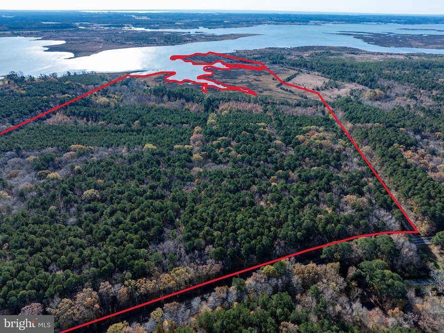
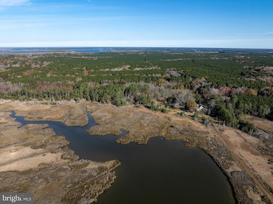
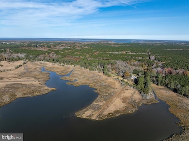
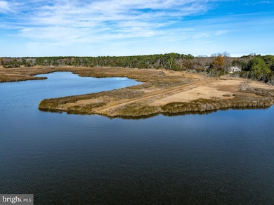
- 2,280 Feet of Waterfront
- 3 Fireplaces
- Cooling System Powered By Renewable Energy
- 156 Acre Lot
- No HOA
- Central Heating
About This Home
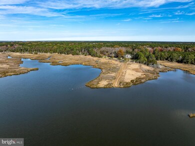
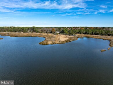
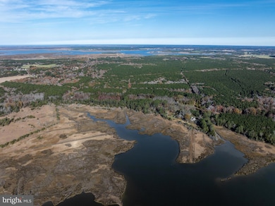
Cedar Point Farm is a rare, intact nineteenth-century Chesapeake farmstead set along the Big Annemessex River between Manokin and Upper Fairmount. Approached by a long, tree-lined lane from Fairmount Road, the property encompasses upland fields, mature woodland, tidal marsh, ponds, and more than 2,200 feet of protected river frontage. The landscape is one of the most historically significant and ecologically rich tracts remaining in lower Somerset County. Originally constructed in the third quarter of the nineteenth century, the farmhouse reflects the architectural transition of rural Somerset during this period. Tradition and documentary evidence associate its principal construction phase with the 1881 marriage of Mary “Mollie” E. Ballard and Charles A. Curtis, descendants of the long-established Waters and Ballard families of Tudor Hall. The two-story side-hall/parlor plan features original arched doorway trim, turned newel post, walnut stair rail, rear service wing, and a two-story porch with lattice balusterwork. Subsequent early-twentieth-century improvements added a west wing and shed dormers while retaining the overall historic character. Accompanying the residence are several nineteenth- and early-twentieth-century outbuildings, including a board-and-batten barn, beaded weatherboard smokehouse, pump houses, sheds, and remnants of an earlier detached kitchen chimney. These structures reinforce the authenticity and continuity of the farm as a working Chesapeake landscape. Cedar Point Farm consists of two contiguous parcels—Tax Map 39, Parcels 363 and 193—held together as a single historic property. Both parcels are protected in perpetuity under a 2016 Conservation Easement granted to the Maryland Environmental Trust (MET) and the Lower Shore Land Trust (LSLT). The easement was established to preserve the property's agricultural productivity, forest resources, wetlands, wildlife habitat, and scenic Chesapeake shoreline. The easement safeguards approximately: 111 acres of mature forest,
36 acres of tidal and forested wetlands,
2 acres of ponds,
2,280 linear feet of Big Annemessex River frontage, and
Habitat for Forest Interior Dwelling Birds and State-significant species.
The land lies within a Targeted Ecological Area designated by Maryland DNR and sits adjacent to the Fairmount Wildlife Management Area and Chesapeake Forest Lands, forming part of a more than 5,000-acre protected block of conserved Chesapeake habitat. A mandatory 100-foot natural buffer along the river restricts disturbance and maintains the property’s scenic and ecological integrity. Property is subject to a no hunting covenant held by the current owner. GIS acres and deeded acres do not align. Buyer to perform their own due diligence. Additional information and documents available through listing agent.
Listing Agent
(410) 934-3478 ben@thelandgroup.us The Land Group License #RB-0020805 Listed on: 12/09/2025
Home Details
Home Type
- Single Family
Est. Annual Taxes
- $2,446
Year Built
- Built in 1880
Lot Details
- 156 Acre Lot
- 2,280 Feet of Waterfront
- Home fronts navigable water
Parking
- Driveway
Home Design
- Frame Construction
Interior Spaces
- 2,848 Sq Ft Home
- Property has 3 Levels
- 3 Fireplaces
- Brick Fireplace
Bedrooms and Bathrooms
- 4 Main Level Bedrooms
Outdoor Features
- Water Access
- River Nearby
Location
- Flood Risk
Utilities
- Cooling System Powered By Renewable Energy
- Central Heating
- Heat Pump System
- Geothermal Heating and Cooling
- Electric Water Heater
- Septic Tank
Community Details
- No Home Owners Association
Listing and Financial Details
- Assessor Parcel Number 2006100953
Map
Home Values in the Area
Average Home Value in this Area
Tax History
| Year | Tax Paid | Tax Assessment Tax Assessment Total Assessment is a certain percentage of the fair market value that is determined by local assessors to be the total taxable value of land and additions on the property. | Land | Improvement |
|---|---|---|---|---|
| 2025 | $2,516 | $220,000 | $0 | $0 |
| 2024 | $2,310 | $201,400 | $143,200 | $58,200 |
| 2023 | $2,286 | $199,300 | $0 | $0 |
| 2022 | $2,193 | $197,200 | $0 | $0 |
| 2021 | $2,239 | $195,100 | $143,200 | $51,900 |
| 2020 | $2,239 | $195,100 | $143,200 | $51,900 |
| 2019 | $2,179 | $195,100 | $143,200 | $51,900 |
| 2018 | $2,251 | $196,100 | $143,200 | $52,900 |
| 2017 | $2,241 | $223,400 | $0 | $0 |
| 2016 | $3,034 | $223,400 | $0 | $0 |
| 2015 | $3,034 | $272,800 | $0 | $0 |
| 2014 | $1,637 | $272,800 | $0 | $0 |
Property History
| Date | Event | Price | List to Sale | Price per Sq Ft |
|---|---|---|---|---|
| 12/09/2025 12/09/25 | For Sale | $1,300,000 | -- | $456 / Sq Ft |
Source: Bright MLS
MLS Number: MDSO2006688
APN: 06-100953
Disclaimer: Certain information contained herein is derived from information provided by parties other than Homes.com. All information provided is deemed reliable, but is not guaranteed to be accurate and should be independently verified.
![]() The data relating to real estate for sale on this website appears in part through the BRIGHT Internet Data Exchange program, a voluntary cooperative exchange of property listing data between licensed real estate brokerage firms, and is provided by BRIGHT through a licensing agreement.
The data relating to real estate for sale on this website appears in part through the BRIGHT Internet Data Exchange program, a voluntary cooperative exchange of property listing data between licensed real estate brokerage firms, and is provided by BRIGHT through a licensing agreement.
Listing information is from various brokers who participate in the Bright MLS IDX program and not all listings may be visible on the site.
The property information being provided on or through the website is for the personal, non-commercial use of consumers and such information may not be used for any purpose other than to identify prospective properties consumers may be interested in purchasing.
Some properties which appear for sale on the website may no longer be available because they are for instance, under contract, sold or are no longer being offered for sale.
Property information displayed is deemed reliable but is not guaranteed.
Copyright 2026 Bright MLS, Inc.
- 0 Fairmount Rd Unit MDSO2006840
- 8339 Upper Hill Rd
- 7461 Lower Hill Rd
- -R R R Maddox Rd
- 6327 Charles Cannon Rd
- 6664 Crisfield Hwy
- 9554 Millard Long Rd
- 0 Revells Neck Rd Unit MDSO2006932
- 29769 Kingston Ln
- 0 Old Westover Marion Rd Unit MDSO2006834
- LOT 2 Fairmount Rd
- 28085 Coves Way
- 0 Carrolton Ct
- 0 Rumbley Rd Unit MDSO2005364
- 5734 Crisfield Hwy
- 81 Davis Rd
- 0 Ranford Williams Rd
- 5620 Tulls Corner Rd
- 0 Clarence Barnes Rd
- 27068 Annie Hyland Rd
- 8034 Riverview Rd
- 30514 Dr William P Hytche Blvd Unit B
- 30514 Dr William P Hytche Blvd Unit C
- 30514 Dr William P Hytche Blvd Unit D
- 30630 Umes Blvd Unit V-102
- 207 Broad St
- 417 Walnut St Unit 2
- 621 Cedar St
- 242 Morgans Ct
- 241 Morgans Ct
- 2005 S Old Mill Dr
- 2007 S Old Mill Dr
- 1726 Cedar St
- 3555 Green Hill Church Rd
- 23406 Saxis Rd
- 5956 Whitesburg Rd
- 213 N Brown St
- 215 N Brown St
- 221 N Brown St
- 223 N Brown St

Ask me questions while you tour the home.