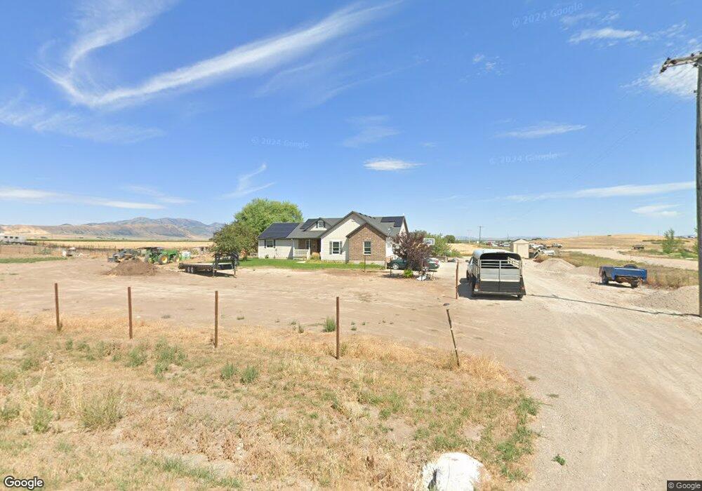
2796 W 3600 S Weston, ID 83286
Estimated Value: $507,000 - $626,000
4
Beds
2
Baths
2,196
Sq Ft
$268/Sq Ft
Est. Value
About This Home
This home is located at 2796 W 3600 S, Weston, ID 83286 and is currently estimated at $587,443, approximately $267 per square foot. 2796 W 3600 S is a home with nearby schools including Harold B. Lee Elementary School, Harold B. Lee Middle School, and West Side Senior High School.
Ownership History
Date
Name
Owned For
Owner Type
Purchase Details
Closed on
Jun 23, 2020
Sold by
Nelson Ryan K and Nelson Jolene
Bought by
Nelson Ryan and Nelson Karla J
Current Estimated Value
Home Financials for this Owner
Home Financials are based on the most recent Mortgage that was taken out on this home.
Original Mortgage
$154,313
Outstanding Balance
$136,787
Interest Rate
3.2%
Mortgage Type
New Conventional
Estimated Equity
$450,656
Purchase Details
Closed on
Aug 20, 2012
Sold by
Turnbow Benjamin A and Turnbow Shari
Bought by
Nelson Ryan K and Nelson Jolene
Create a Home Valuation Report for This Property
The Home Valuation Report is an in-depth analysis detailing your home's value as well as a comparison with similar homes in the area
Home Values in the Area
Average Home Value in this Area
Purchase History
| Date | Buyer | Sale Price | Title Company |
|---|---|---|---|
| Nelson Ryan | -- | Northern Title Company Of Id | |
| Nelson Ryan K | -- | None Available |
Source: Public Records
Mortgage History
| Date | Status | Borrower | Loan Amount |
|---|---|---|---|
| Open | Nelson Ryan | $154,313 |
Source: Public Records
Tax History Compared to Growth
Tax History
| Year | Tax Paid | Tax Assessment Tax Assessment Total Assessment is a certain percentage of the fair market value that is determined by local assessors to be the total taxable value of land and additions on the property. | Land | Improvement |
|---|---|---|---|---|
| 2024 | $1,748 | $468,995 | $80,049 | $388,946 |
| 2023 | $1,338 | $390,618 | $80,049 | $310,569 |
| 2022 | $1,579 | $356,346 | $41,560 | $314,786 |
| 2021 | $1,551 | $325,384 | $41,560 | $283,824 |
| 2019 | $1,435 | $256,357 | $41,560 | $214,797 |
| 2018 | $1,421 | $246,037 | $32,000 | $214,037 |
| 2017 | $1,291 | $224,846 | $32,000 | $192,846 |
| 2016 | $1,338 | $217,571 | $32,000 | $185,571 |
| 2015 | $1,355 | $217,571 | $32,000 | $185,571 |
| 2014 | $2,122 | $217,571 | $32,000 | $185,571 |
| 2013 | -- | $32,000 | $32,000 | $0 |
Source: Public Records
Map
Nearby Homes
- 2289 W 2800 S
- 2673 S 2400 W
- 1850 W 3600 S Unit 22
- 47 E Depot St
- 4650 S 1400 W Unit 3
- 4650 S 1400 W Unit 2
- 4650 S 1400 W Unit 1
- 284 W 2nd N
- 4650 S 1400 W
- 4800 W 5400 S
- 272 S 400 W
- 252 S 400 W
- 309 W 2000 S
- 6900 W 2200 S
- 5300 W 5800 S Unit 5
- 5100 W 5800 S Unit 4
- 4700 W 5800 S Unit 2
- 4500 W 5800 S Unit 1
- 1207 S 600 W
- 4405 W 13400 N
- 2882 W 3600 S
- 2899 W 3600 S
- 2735 W 3600 S
- 2710 W 3600 S Unit 13
- 2762 W 3600 S Unit 8
- 2746 W 3600 S
- 2979 W 3600 S
- 2979 W 3600 S Unit 1
- 2975 W 3600 S
- 2692 W 3600 S Unit 10
- 3012 W 3600 S
- 2656 W 3600 S Unit 11
- 2536 W 3600 S
- 2538 W 3600 S
- 2600 W 3600 S Unit 12
- 2600 W 3600 S Unit 11
- 3026 W 3600 S
- 2559 W 3600 S
- 3753 S 3200 W
- 2580 W 3600 S Unit 13