
Seller's Agent in 2022
Peter Beauchemin
Realty One Group Next Level
(603) 264-0366
2 in this area
96 Total Sales


Estimated Value: $315,709
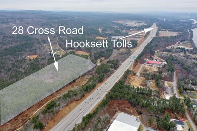
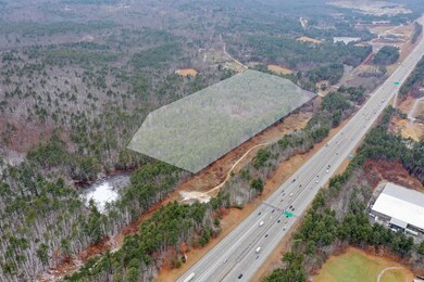
Rare opportunity to own 30 acres of land with 832 feet of road frontage Zoned LDR-Low Density Residential in Hooksett, NH. Just minutes from Route 93, only one hour away from the White Mountains, New Hampshire Seacoast or Boston, MA and Logan International Airport and close to the City of Manchester and Manchester Regional Airport. Bring your builder and make your dream home a reality. Would make grand estate or possibly family compound. Wetlands limit development potential. Portion of property is in flood zone. Land is in current use. Buyer to pay any land use change tax. Buyer to perform their own due diligence and verify information contained herein is true and correct. See info packet and aerial photos to fully experience this exceptional acreage.
Last Agent to Sell the Property
Realty One Group Next Level License #059657 Listed on: 12/28/2021
| Date | Buyer | Sale Price | Title Company |
|---|---|---|---|
| Scott Raymond | $265,000 | None Available | |
| Scott Raymond | $265,000 | None Available | |
| Liberty Land Invs Llc | $199,933 | None Available | |
| Liberty Land Invs Llc | $199,933 | None Available | |
| W Addison Jones Mulaire T | -- | -- |
| Date | Status | Borrower | Loan Amount |
|---|---|---|---|
| Previous Owner | Liberty Land Invs Llc | $250,000 |
| Date | Event | Price | List to Sale | Price per Sq Ft |
|---|---|---|---|---|
| 10/18/2022 10/18/22 | Sold | $199,900 | 0.0% | -- |
| 10/07/2022 10/07/22 | Pending | -- | -- | -- |
| 10/05/2022 10/05/22 | For Sale | $199,900 | 0.0% | -- |
| 09/15/2022 09/15/22 | Pending | -- | -- | -- |
| 09/12/2022 09/12/22 | Price Changed | $199,900 | -20.0% | -- |
| 06/16/2022 06/16/22 | Price Changed | $249,900 | -9.1% | -- |
| 03/09/2022 03/09/22 | Price Changed | $274,900 | -8.4% | -- |
| 12/28/2021 12/28/21 | For Sale | $300,000 | -- | -- |
| Year | Tax Paid | Tax Assessment Tax Assessment Total Assessment is a certain percentage of the fair market value that is determined by local assessors to be the total taxable value of land and additions on the property. | Land | Improvement |
|---|---|---|---|---|
| 2024 | $41 | $2,393 | $2,393 | $0 |
| 2023 | $48 | $3,030 | $3,030 | $0 |
| 2022 | $81 | $3,360 | $3,360 | $0 |
| 2021 | $75 | $3,360 | $3,360 | $0 |
| 2020 | $5,486 | $3,360 | $3,360 | $0 |
| 2019 | $72 | $3,360 | $3,360 | $0 |
| 2018 | $92 | $3,540 | $3,540 | $0 |
| 2017 | $92 | $3,450 | $3,450 | $0 |
| 2016 | $4,449 | $3,450 | $3,450 | $0 |
| 2015 | $3,953 | $3,330 | $3,330 | $0 |
| 2014 | $2,820 | $3,330 | $3,330 | $0 |
| 2013 | -- | $4,200 | $4,200 | $0 |
Seller's Agent in 2022
Peter Beauchemin
Realty One Group Next Level
(603) 264-0366
2 in this area
96 Total Sales
Buyer's Agent in 2022
Kerri Crowley
Keller Williams Realty-Metropolitan
(603) 714-8325
12 in this area
119 Total Sales
Source: PrimeMLS
MLS Number: 4894051
APN: HOOK-000017-000000-000040
Disclaimer: Certain information contained herein is derived from information provided by parties other than Homes.com. All information provided is deemed reliable, but is not guaranteed to be accurate and should be independently verified.
![]() Copyright 2026 PrimeMLS, Inc. All rights reserved. This information is deemed reliable, but not guaranteed. The data relating to real estate displayed on this display comes in part from the IDX Program of PrimeMLS. The information being provided is for consumers’ personal, non-commercial use and may not be used for any purpose other than to identify prospective properties consumers may be interested in purchasing.
Copyright 2026 PrimeMLS, Inc. All rights reserved. This information is deemed reliable, but not guaranteed. The data relating to real estate displayed on this display comes in part from the IDX Program of PrimeMLS. The information being provided is for consumers’ personal, non-commercial use and may not be used for any purpose other than to identify prospective properties consumers may be interested in purchasing.
Ask me questions while you tour the home.