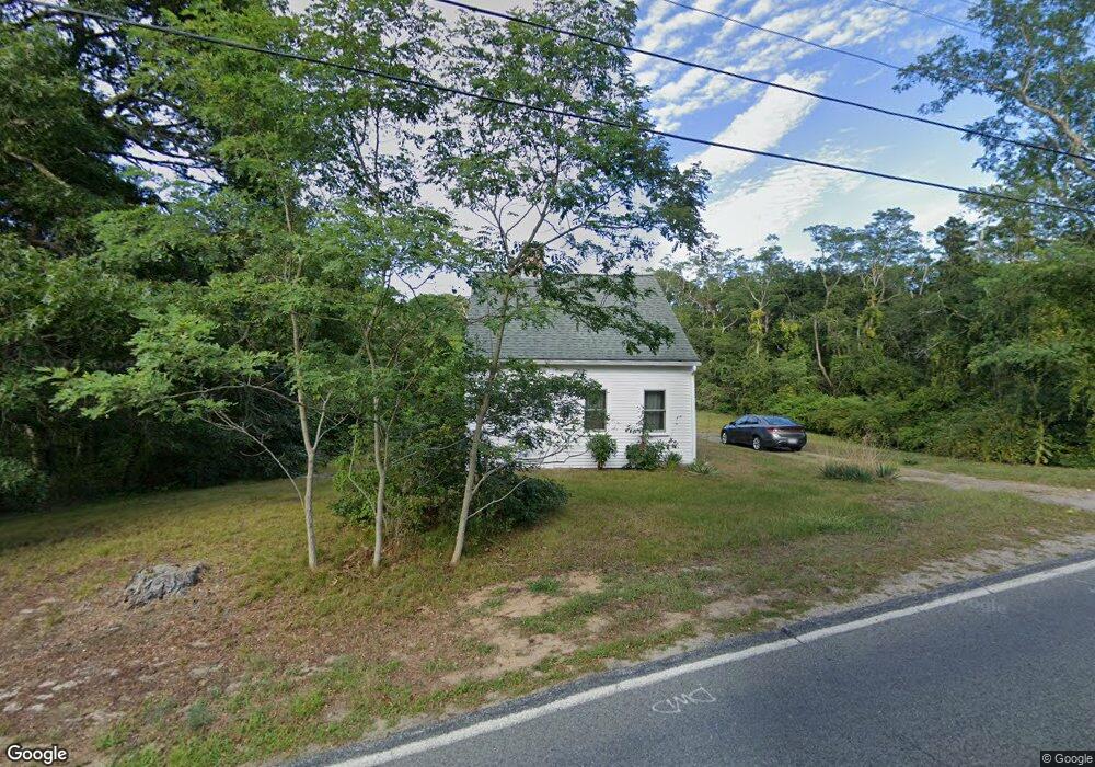
28 Depot Rd Dennis Port, MA 02639
Dennis Port NeighborhoodEstimated Value: $479,940 - $632,000
3
Beds
1
Bath
1,336
Sq Ft
$400/Sq Ft
Est. Value
About This Home
This home is located at 28 Depot Rd, Dennis Port, MA 02639 and is currently estimated at $534,735, approximately $400 per square foot. 28 Depot Rd is a home located in Barnstable County with nearby schools including Dennis-Yarmouth Regional High School and St. Pius X. School.
Ownership History
Date
Name
Owned For
Owner Type
Purchase Details
Closed on
Feb 3, 2025
Sold by
Morritt Jeremy W and Lounsbury Madeline A
Bought by
Lounsbury Madeline A and Lounsbury Nicholas W
Current Estimated Value
Purchase Details
Closed on
Jan 13, 2025
Sold by
Morritt Jeremy W
Bought by
Morritt Jeremy W and Lounsbury Madeline A
Purchase Details
Closed on
Sep 26, 2022
Sold by
Lounsbury Madeleine A and White Dylan
Bought by
Morritt Jeremy W
Purchase Details
Closed on
May 14, 2021
Sold by
Morritt Evelyn B S Est and Morritt
Bought by
Morritt Jeremy W and Lounsbury Madeleine A
Create a Home Valuation Report for This Property
The Home Valuation Report is an in-depth analysis detailing your home's value as well as a comparison with similar homes in the area
Home Values in the Area
Average Home Value in this Area
Purchase History
| Date | Buyer | Sale Price | Title Company |
|---|---|---|---|
| Lounsbury Madeline A | -- | None Available | |
| Lounsbury Madeline A | -- | None Available | |
| Morritt Jeremy W | -- | None Available | |
| Morritt Jeremy W | -- | None Available | |
| Morritt Jeremy W | -- | None Available | |
| Morritt Jeremy W | -- | None Available | |
| Morritt Jeremy W | -- | None Available | |
| Morritt Jeremy W | -- | None Available | |
| Morritt Jeremy W | -- | None Available | |
| Morritt Jeremy W | -- | None Available |
Source: Public Records
Tax History Compared to Growth
Tax History
| Year | Tax Paid | Tax Assessment Tax Assessment Total Assessment is a certain percentage of the fair market value that is determined by local assessors to be the total taxable value of land and additions on the property. | Land | Improvement |
|---|---|---|---|---|
| 2025 | $1,506 | $347,800 | $160,500 | $187,300 |
| 2024 | $1,497 | $341,100 | $163,400 | $177,700 |
| 2023 | $1,449 | $310,200 | $148,600 | $161,600 |
| 2022 | $1,508 | $269,300 | $148,700 | $120,600 |
| 2021 | $0 | $239,300 | $131,200 | $108,100 |
| 2020 | $1,453 | $238,200 | $131,200 | $107,000 |
| 2019 | $1,473 | $238,800 | $128,700 | $110,100 |
| 2018 | $0 | $220,100 | $122,500 | $97,600 |
| 2017 | $1,375 | $223,600 | $122,500 | $101,100 |
| 2016 | $1,459 | $223,400 | $136,100 | $87,300 |
| 2015 | $1,430 | $223,400 | $136,100 | $87,300 |
| 2014 | $1,265 | $199,200 | $108,900 | $90,300 |
Source: Public Records
Map
Nearby Homes
- 11 Lane Rd
- 91 Depot Rd W
- 537 Depot St
- 141 Division St
- 141 Division St
- 24 Indian Trail
- 47 Telegraph Rd Unit 1
- 9 Country Ln
- 78 Upper County Rd Unit A&B
- 78 Upper County Rd
- 9 Bells Neck Rd Unit 10
- 45 Route 28
- 360 Center St
- 64 Smith St
- 9 Mansion St
- 12 Candlewood Ln Unit 2-9
- 10 Candlewood Ln Unit 2-1
- 171 Searsville Rd
- 116 Searsville Rd
- 79 Massachusetts 28