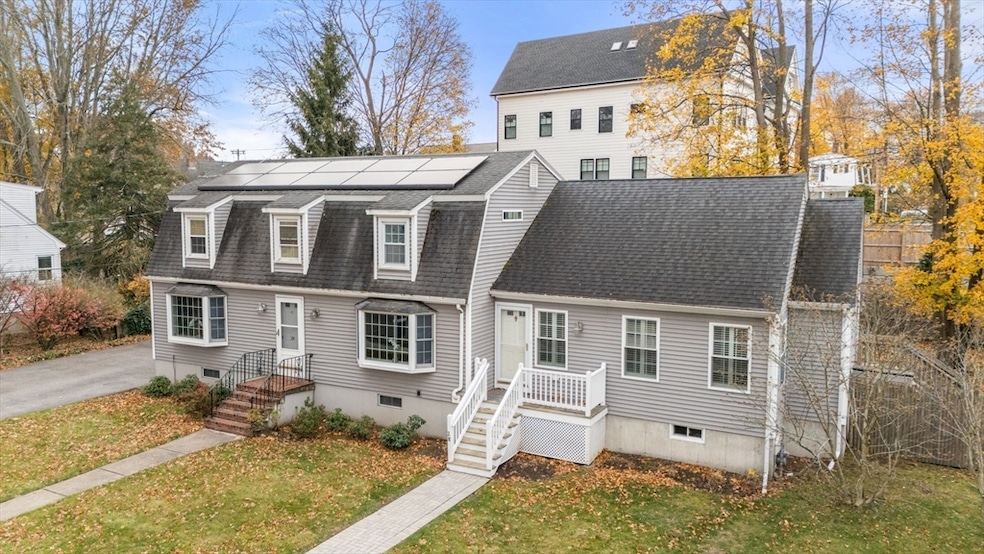
28 Dow Rd West Roxbury, MA 02132
West Roxbury NeighborhoodEstimated payment $6,289/month
Highlights
- Golf Course Community
- Open Floorplan
- Deck
- Medical Services
- Colonial Architecture
- Property is near public transit
About This Home
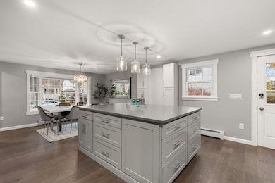
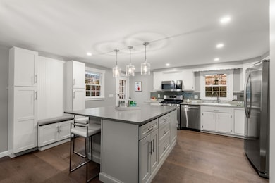
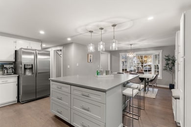
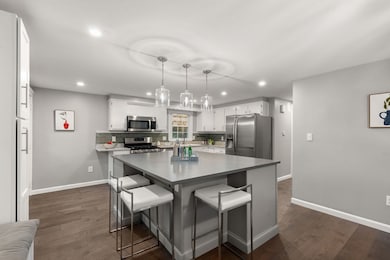
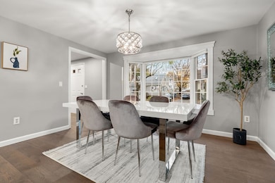
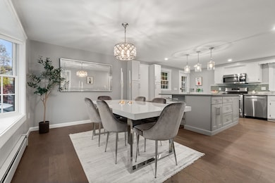
Welcome to 28 Dow Rd, a thoughtfully expanded home nestled on a dead-end street in one of West Roxbury’s most coveted neighborhoods. This home offers 2,500+ sqft of living space, on a generous 10,000+ sqft lot, w/ versatile layout ideal for multi-generational living.The main level feat. a bright, open layout w/ generous living & dining areas, a large updated kitchen w/ new oversized island, & half bath. Upstairs, 3 comfortable BDRMS, an updated full bath w/ double vanity, a walk-in closet in the primary BDRM, & plenty of storage. An in-law suite added in 2012, w/ private entrance provides a retreat for grandparents, nanny or out of town guests. Complete w/ its own kitchen, LR, BDRM, BTH, laundry, basement & full attic. Possibility of making this a legal ADU w/ income generating potential for the next owner. Newly installed solar panels, ample outdoor space, double wide driveway, & storage shed - don’t miss your opportunity to own a spacious, turn-key home w/ flexible living options.

Home Details
Home Type
- Single Family
Est. Annual Taxes
- $5,761
Year Built
- Built in 1983 | Remodeled
Lot Details
- 0.25 Acre Lot
- Level Lot
- Garden
- Property is zoned R1
Home Design
- Colonial Architecture
- Block Foundation
- Shingle Roof
- Stone
Interior Spaces
- Open Floorplan
- Recessed Lighting
- Decorative Lighting
- Light Fixtures
- Bay Window
- Home Office
Kitchen
- Stove
- Range
- Microwave
- Freezer
- Dishwasher
- Stainless Steel Appliances
- Kitchen Island
- Solid Surface Countertops
- Disposal
Flooring
- Engineered Wood
- Wall to Wall Carpet
- Tile
Bedrooms and Bathrooms
- 5 Bedrooms
- Primary bedroom located on second floor
- Walk-In Closet
- In-Law or Guest Suite
- Double Vanity
Laundry
- Dryer
- Washer
Partially Finished Basement
- Basement Fills Entire Space Under The House
- Sump Pump
- Laundry in Basement
Parking
- 4 Car Parking Spaces
- Driveway
- Paved Parking
- Open Parking
- Off-Street Parking
Outdoor Features
- Bulkhead
- Deck
- Outdoor Storage
- Porch
Location
- Property is near public transit
- Property is near schools
Schools
- Bps Elementary And Middle School
- Bps High School
Utilities
- Ductless Heating Or Cooling System
- Forced Air Heating and Cooling System
- 4 Cooling Zones
- 3 Heating Zones
- Heating System Uses Natural Gas
- Baseboard Heating
Listing and Financial Details
- Assessor Parcel Number W:20 P:08771 S:021,1434088
Community Details
Overview
- No Home Owners Association
- Near Conservation Area
Amenities
- Medical Services
- Shops
- Coin Laundry
Recreation
- Golf Course Community
- Tennis Courts
- Community Pool
- Park
- Jogging Path
- Bike Trail
Map
Home Values in the Area
Average Home Value in this Area
Tax History
| Year | Tax Paid | Tax Assessment Tax Assessment Total Assessment is a certain percentage of the fair market value that is determined by local assessors to be the total taxable value of land and additions on the property. | Land | Improvement |
|---|---|---|---|---|
| 2025 | $9,699 | $837,600 | $239,200 | $598,400 |
| 2024 | $10,021 | $919,400 | $270,500 | $648,900 |
| 2023 | $9,404 | $875,600 | $257,600 | $618,000 |
| 2022 | $8,660 | $796,000 | $234,200 | $561,800 |
| 2021 | $8,203 | $768,800 | $229,600 | $539,200 |
| 2020 | $7,702 | $729,400 | $196,800 | $532,600 |
| 2019 | $7,317 | $694,200 | $165,800 | $528,400 |
| 2018 | $6,737 | $642,800 | $165,800 | $477,000 |
| 2017 | $6,672 | $630,000 | $165,800 | $464,200 |
| 2016 | $6,728 | $611,600 | $165,800 | $445,800 |
| 2015 | $6,854 | $566,000 | $196,000 | $370,000 |
| 2014 | $6,718 | $534,000 | $196,000 | $338,000 |
Property History
| Date | Event | Price | List to Sale | Price per Sq Ft |
|---|---|---|---|---|
| 11/12/2025 11/12/25 | For Sale | $1,100,000 | -- | $434 / Sq Ft |
Purchase History
| Date | Type | Sale Price | Title Company |
|---|---|---|---|
| Quit Claim Deed | $550,000 | -- | |
| Quit Claim Deed | -- | -- |
Mortgage History
| Date | Status | Loan Amount | Loan Type |
|---|---|---|---|
| Open | $561,825 | VA | |
| Previous Owner | $150,000 | No Value Available | |
| Previous Owner | $32,000 | No Value Available | |
| Previous Owner | $40,000 | No Value Available |
Source: MLS Property Information Network (MLS PIN)
MLS Number: 73454055
APN: WROX-000000-000020-008771-000021
Disclaimer: Certain information contained herein is derived from information provided by parties other than Homes.com. All information provided is deemed reliable, but is not guaranteed to be accurate and should be independently verified.
![]() The property listing data and information, or the Images, set forth herein were provided to MLS Property Information Network, Inc. from third party sources, including sellers, lessors and public records, and were compiled by MLS Property Information Network, Inc. The property listing data and information, and the Images, are for the personal, non-commercial use of consumers having a good faith interest in purchasing or leasing listed properties of the type displayed to them and may not be used for any purpose other than to identify prospective properties which such consumers may have a good faith interest in purchasing or leasing. MLS Property Information Network, Inc. and its subscribers disclaim any and all representations and warranties as to the accuracy of the property listing data and information, or as to the accuracy of any of the Images, set forth herein.
The property listing data and information, or the Images, set forth herein were provided to MLS Property Information Network, Inc. from third party sources, including sellers, lessors and public records, and were compiled by MLS Property Information Network, Inc. The property listing data and information, and the Images, are for the personal, non-commercial use of consumers having a good faith interest in purchasing or leasing listed properties of the type displayed to them and may not be used for any purpose other than to identify prospective properties which such consumers may have a good faith interest in purchasing or leasing. MLS Property Information Network, Inc. and its subscribers disclaim any and all representations and warranties as to the accuracy of the property listing data and information, or as to the accuracy of any of the Images, set forth herein.
- 340 Baker St Unit 1
- 1 Dow Rd
- 59 Chesbrough Rd
- 1216 Vfw Pkwy Unit 40
- 105 Chesbrough Rd
- 1214 Vfw Pkwy Unit 30
- 1214 Vfw Pkwy Unit 37
- 183 Temple St
- 14 Sanborn Ave
- 990 Vfw Pkwy Unit 204
- 331 Vermont St
- 7 Cass St Unit 6
- 15 Cass St Unit 3
- 27-29 Temple St
- 9 Carroll St
- 539 Lagrange St
- 76 Potomac St
- 425 Lagrange St Unit 203
- 63 Johnson St
- 577 Baker St Unit 577
- 80 Sanborn Ave Unit 2
- 1208D Vfw Pkwy
- 91 Gardner St
- 91 Gardner St
- 91 Gardner St
- 91 Gardner St
- 91 Gardner St
- 91 Gardner St
- 333 Vermont St Unit 2
- 331 Vermont St Unit 1
- 80 Gardner St Unit 6B
- 80 Gardner St Unit 24
- 50 Gardner St Unit 10
- 50 Gardner St Unit 32
- 97 Spring St Unit C-2
- 91 Spring St Unit C2
- 1235 Vfw Pkwy
- 199 Gardner St Unit 403
- 199 Gardner St Unit 209
- 199 Gardner St Unit 402