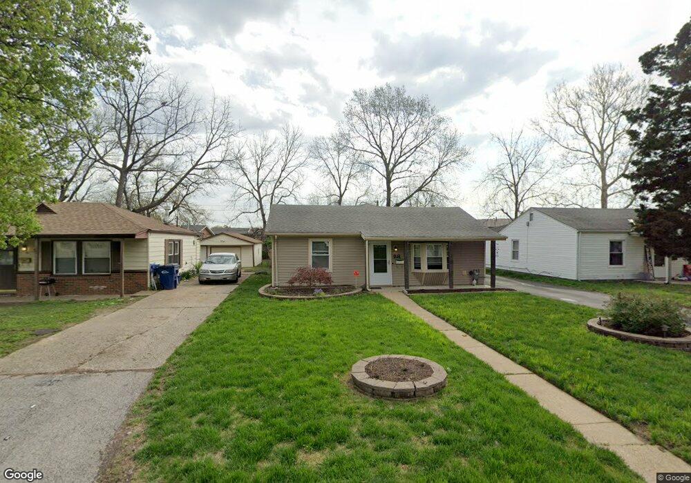
28 Florval Dr Florissant, MO 63031
Estimated Value: $126,000 - $165,738
3
Beds
2
Baths
1,443
Sq Ft
$101/Sq Ft
Est. Value
About This Home
This home is located at 28 Florval Dr, Florissant, MO 63031 and is currently estimated at $146,435, approximately $101 per square foot. 28 Florval Dr is a home located in St. Louis County with nearby schools including Parker Road Elementary School, Cross Keys Middle School, and McCluer North High School.
Ownership History
Date
Name
Owned For
Owner Type
Purchase Details
Closed on
Aug 25, 2006
Sold by
Kline Douglas M and Kline Susan M
Bought by
Williams Dawn M
Current Estimated Value
Home Financials for this Owner
Home Financials are based on the most recent Mortgage that was taken out on this home.
Original Mortgage
$113,900
Outstanding Balance
$67,937
Interest Rate
6.64%
Mortgage Type
New Conventional
Estimated Equity
$78,498
Purchase Details
Closed on
Apr 29, 1998
Sold by
Guinn Garry L and Guinn Dinaise
Bought by
Kline Melvin Douglas
Home Financials for this Owner
Home Financials are based on the most recent Mortgage that was taken out on this home.
Original Mortgage
$12,000
Interest Rate
7.09%
Purchase Details
Closed on
Mar 18, 1997
Sold by
Marie Wolff Dinaise and Marie Dinaise Marie
Bought by
Guinn Garry L
Create a Home Valuation Report for This Property
The Home Valuation Report is an in-depth analysis detailing your home's value as well as a comparison with similar homes in the area
Home Values in the Area
Average Home Value in this Area
Purchase History
| Date | Buyer | Sale Price | Title Company |
|---|---|---|---|
| Williams Dawn M | $113,900 | None Available | |
| Kline Melvin Douglas | -- | -- | |
| Guinn Garry L | -- | -- |
Source: Public Records
Mortgage History
| Date | Status | Borrower | Loan Amount |
|---|---|---|---|
| Open | Williams Dawn M | $113,900 | |
| Previous Owner | Kline Melvin Douglas | $12,000 |
Source: Public Records
Tax History Compared to Growth
Tax History
| Year | Tax Paid | Tax Assessment Tax Assessment Total Assessment is a certain percentage of the fair market value that is determined by local assessors to be the total taxable value of land and additions on the property. | Land | Improvement |
|---|---|---|---|---|
| 2025 | $2,103 | $30,200 | $5,420 | $24,780 |
| 2024 | $2,103 | $27,110 | $2,450 | $24,660 |
| 2023 | $2,096 | $27,110 | $2,450 | $24,660 |
| 2022 | $1,693 | $19,170 | $3,100 | $16,070 |
| 2021 | $1,665 | $19,170 | $3,100 | $16,070 |
| 2020 | $1,492 | $16,170 | $3,100 | $13,070 |
| 2019 | $1,463 | $16,170 | $3,100 | $13,070 |
| 2018 | $1,412 | $13,940 | $2,050 | $11,890 |
| 2017 | $1,405 | $13,940 | $2,050 | $11,890 |
| 2016 | $1,530 | $14,820 | $2,430 | $12,390 |
| 2015 | $1,539 | $14,820 | $2,430 | $12,390 |
| 2014 | $1,536 | $15,280 | $2,470 | $12,810 |
Source: Public Records
Map
Nearby Homes
- 43 Saint Celeste Dr
- 37 Marquette Dr
- 1205 Fox Run Dr
- 1580 Queens Dr
- 13 Saint Celeste Dr
- 1215 Pamela Dr
- 1545 Bluefield Dr
- 1148 Boone St
- 6 Redwood Dr
- 1415 Saint Jean St
- 1365 Saint Jean St
- 1480 Burning Tree Dr
- 1980 Parker Rd
- 1090 Saint Joseph St
- 865 Boone St
- 2375 Hummingbird Dr
- 1420 Nashua Dr
- 1200 Bluefield Dr
- 1023 Saint Denis St
- 1665 Saddlespur Ln